
 British Columbia stands at a crossroads. The province’s coastal waters—long celebrated for their rich marine ecosystems, vibrant First Nations territories, and world-renowned ferry and tourism industries—are poised to become major corridors for liquefied natural gas (LNG) shipping. With multiple LNG export terminal proposals progressing along the coast, from the already-operational LNG Canada facility in Kitimat to the under-construction Woodfibre LNG near Squamish and the planned Tilbury Phase 2 expansion in Delta, the question of whether these developments can coexist safely with coastal communities has never been more urgent. This article examines the potential hazards of LNG tanker operations, the regulatory and emergency preparedness gaps that critics say remain unaddressed, and the profound implications for the people, wildlife, and economies of Canada’s West Coast.
What Is LNG and Why Does It Matter?
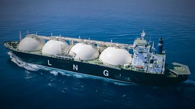
Liquefied natural gas is methane that has been cooled to approximately -162°C, at which point it becomes a colourless, odourless, non-corrosive liquid. This process reduces its volume by about 600 times, making it economically feasible to transport by ship. An LNG carrier is a highly specialised vessel. Modern carriers are double-hulled, typically 300 metres long—equivalent to twice the height of Vancouver’s Harbour Centre—and can carry around 180,000 cubic metres of LNG, roughly the equivalent of the water contained in 72 Olympic-sized swimming pools.
The industry is quick to point out that LNG shipping has an excellent safety record. According to the International Group of Liquefied Natural Gas Importers (GIIGNL), there have been no collisions, explosions, or fires reported on LNG carriers since the first commercial voyage in 1964. This safety record is attributed to rigorous engineering standards, double-hull construction, advanced containment systems, and stringent crew training. LNG carriers are required to comply with the International Code for the Construction and Equipment of Ships Carrying Liquefied Gases in Bulk, and must be equipped with double-hulled cargo containment systems supported by containment breach sensors to reduce the probability of leakage or rupture.
Yet the safety record of the global industry does not automatically translate into safety for the specific conditions of British Columbia’s coast. The concern is not merely about whether an accident will happen, but about the consequences if one does—and about the cumulative risks of dramatically increased vessel traffic through some of the most ecologically sensitive and geographically challenging waters in North America.
The Hazards of LNG: Vapour Clouds, Pool Fires, and Cascading Consequences
The physical properties of LNG create specific hazard profiles that distinguish it from conventional oil spills. When LNG is released—whether through a hull breach, a grounding, a collision, or a loading accident—it rapidly warms and vaporises, forming a dense, visible vapour cloud. This cloud can travel considerable distances downwind, and if it encounters an ignition source, it can ignite, creating a flash fire or, under certain conditions, a vapour cloud explosion.
If the release occurs on water, the LNG can pool on the surface, where it boils vigorously as it absorbs heat from the sea. This can result in a pool fire—a large, intense fire with high thermal radiation that can melt steel at considerable distances. Sandia National Laboratories, a division of the U.S. Department of Energy, has conducted extensive research on LNG hazards. A 2004 Sandia study estimated that a pool fire could be hot enough to melt steel at distances of 1,200 feet, and that the most likely distance for a burn from an LNG fire would be about 1,600 metres—approximately one mile.
Sandia’s work has also examined the potential for cascading failure of LNG tanks on land-based facilities. Their studies concluded that only three of five tanks would typically be involved in a cascading failure scenario, but the duration of the LNG fire would be significant. More recent Sandia research has provided datasets for validating models of pool fires, trench fires, jet fires, fireballs, and vapour cloud fires, specifically for predicting thermal hazards from accidents involving LNG.
The critical issue for coastal communities is proximity. Unlike oil spills, which primarily affect water and shorelines, LNG fires and vapour clouds can directly threaten human populations. The lethal radius of an LNG pool fire depends on the volume released, the weather conditions, and the surrounding terrain. But even under conservative estimates, a large-scale release near a populated area could create a thermal hazard zone extending well beyond the immediate vicinity of the vessel.
The Sandia Studies and Their Implications
Sandia National Laboratories’ LNG hazard studies have become a crucial reference point for regulators and safety advocates alike. The 2004 study, commissioned by the U.S. Department of Energy, examined the consequences of large LNG spills on water and land, including pool fires and vapour dispersion. The study’s findings—that an LNG fire could be hot enough to melt steel at 1,200 feet and that the most likely burn distance was about one mile—have been used to inform hazard assessments for LNG terminals and shipping routes.
However, the Sandia studies have also been criticised for relying on scenarios that may not reflect the full range of possible accident outcomes. The 2004 study assumed a relatively rapid release of LNG and did not fully account for the potential for cascading failures, the effects of complex terrain, or the interaction of LNG vapour with the built environment. Moreover, the study was focused on land-based facilities; applying its findings to the marine environment, where spills on water create unique dynamics, requires careful adaptation.
Despite these limitations, the Sandia research underscores a fundamental point: LNG accidents are not simply oil spills with different chemistry. They involve fire, explosion, and atmospheric dispersion hazards that can have immediate and catastrophic effects on human life. Any risk assessment for LNG shipping near coastal communities must grapple with these realities.
SIGTTO Standards and the Problem of Terminal Siting
The Society of International Gas Tanker and Terminal Operators (SIGTTO) is widely regarded as the de facto world authority on LNG terminal siting and shipping standards. Its guidelines are considered essential reading for any organisation involved in the siting, design, and operation of LNG terminals.
SIGTTO’s siting criteria are explicit. The organisation states that “short approach channels are preferable to long inshore routes which carry more numerous hazards”. It advises that jetties should be placed “in sheltered locations remote from other port users” and that no terminal should be sited where it may be approached by heavy displacement ships with the inherent capability to penetrate the hull of an LNG tanker. SIGTTO also recommends that traffic separation schemes be established in approach routes covering many miles, that anchorages be established at the port entrance and inshore for the safe segregation of LNG carriers, and that terminals not be positioned on the outside of a river bend.
These guidelines exist for good reason. They are based on decades of operational experience and a deep understanding of the unique risks posed by LNG carriers. Yet several proposed LNG terminals in British Columbia appear to be in tension with these recommendations.
The Woodfibre LNG project, for instance, is located on the shores of Átl’ka7tsem/Howe Sound, a UNESCO biosphere reserve. The shipping route to and from Woodfibre is a long inshore route, passing adjacent to the Sea to Sky Highway and communities such as Lions Bay, through Queen Charlotte Channel between Bowen Island and West Vancouver/Horseshoe Bay, past Passage Island, and into the Strait of Georgia. This route carries the vessel through waters heavily used by BC Ferries, recreational boaters, and commercial traffic. SIGTTO’s guidelines explicitly favour short approach channels over long inshore routes, and recommend that terminals be sited suitably distant from centres of population.
Furthermore, the Woodfibre site is on the outside of a bend in the shipping lane to and from Squamish Terminals at the head of Howe Sound. SIGTTO specifically warns against positioning an LNG terminal on the outside of a river bend because a passing ship may strike the berthed carrier if the manoeuvre is not properly executed.
Notably, Woodfibre LNG Limited is not a member of SIGTTO, and neither the company nor its parent, Pacific Oil & Gas Limited, had ever built or operated an LNG terminal before commencing the project. While membership in SIGTTO is not a legal requirement, the absence of a track record in LNG terminal operations raises questions about whether the company can be expected to adhere to the industry’s best practices without external oversight.
LNG Shipping Routes: Narrow Waterways, Populated Coasts, and Critical Habitat
The proposed LNG shipping routes in British Columbia are not abstract lines on a map. They pass through some of the most ecologically sensitive and heavily used waterways in Canada.
On the South Coast, the Woodfibre LNG project and the Tilbury Phase 2 expansion would dramatically increase LNG tanker traffic through the Strait of Georgia, Haro Strait, Boundary Pass, and the Juan de Fuca Strait. According to a 2025 report by Maritime Beyond Methane, these two projects alone would increase LNG production capacity from less than 100,000 tonnes per year in 2015 to nearly six million tonnes by 2035—a sixty-fold expansion. This would add more than 200 LNG tanker transits per year to already busy shipping lanes.
More than 800,000 people in British Columbia and Washington state live within 10 kilometres of the approved LNG tanker routes, including residents of Burnaby, Coquitlam, Richmond, Saanich, Squamish, Surrey, and Vancouver. Within 25 kilometres, the figure rises to 2.8 million people. These routes pass through or skirt the edges of several protected and environmentally sensitive marine areas, and more than 1,000 kilometres of tanker routes pass through federally designated critical habitat for species at risk, including Southern resident killer whales, humpback whales, fin whales, and Chinook salmon.
The tankers themselves are enormous. At 300 metres in length, they are among the largest vessels plying coastal waters. Navigating them through narrow waterways such as Howe Sound and the Fraser River requires precise manoeuvring, favourable weather conditions, and close coordination with other marine traffic. The margin for error is thin, and the consequences of a loss of control—whether due to mechanical failure, human error, or adverse weather—could be severe.
On the North Coast, the LNG Canada project in Kitimat has already begun shipping LNG through the Kitimat fjord system, a 140-kilometre-long waterway that is as little as two kilometres wide at certain points. This fjord system is a haven for at-risk humpback and fin whales, which feed, rest, and socialise in the very same areas where LNG tankers now travel. The first five LNG tanker transits from LNG Canada all occurred at night, when visibility is limited and the risk of ship strikes is heightened.
The Threat to Whales and Marine Ecosystems
The environmental concerns associated with LNG shipping extend well beyond the risk of a catastrophic spill. The mere presence of large, fast-moving vessels in ecologically sensitive waters has profound effects on marine life.
For the Gitga’at Nation, Douglas Channel on British Columbia’s north coast is more than a shipping lane. It is a haven for at-risk humpback and fin whales, which were once wiped out from these waters by commercial whaling but have made a remarkable comeback over the past two decades. Kyle Clifton, acting director of the Gitga’at Oceans and Lands Department, recalls a time when seeing a whale was rare. “Now it’s weird to go out in the boat and not see whales,” he says.
But the return of the whales has coincided with the arrival of LNG tankers. When fully operational, LNG shipping traffic is expected to cause the death of two fin whales and eighteen humpbacks each year over the forty-year lifespan of the project, according to research cited by BC Whales. These deaths would result primarily from ship strikes, as humpbacks and fin whales are highly vulnerable due to their tendency to rest and feed at the surface. Unlike killer whales, they lack prominent dorsal fins, making them hard to spot, and they can surface unexpectedly, resembling logs when lounging in the water.
The underwater noise generated by LNG tankers is another serious concern. Grace Baer, research and project manager for the North Coast Cetacean Society (BC Whales), describes the acoustic impact as creating an “acoustic fog” that hinders the animals’ ability to find food, care for offspring, or communicate with one another. An LNG tanker can significantly degrade the underwater soundscape and disrupt whales’ critical life processes for upwards of forty minutes, depending on the location of the ships and animals.
The cumulative effects of ship strikes, underwater noise, and the potential for spills and pollution threaten not only individual whales but the recovery of entire populations. Southern resident killer whales, already endangered, would be particularly vulnerable to the increased vessel traffic and noise in the Salish Sea. The loss of even a few individuals from these small, genetically distinct populations could have long-term consequences for their survival.
Emergency Preparedness: Are Coastal Communities Ready?
The question of emergency preparedness is perhaps the most urgent for coastal communities. If an LNG tanker were to experience a major release—whether through a collision, grounding, or catastrophic containment failure—how quickly could responders act, and what would the consequences be for nearby populations?
LNG carriers are required to have their own emergency response plans, and vessel crews are trained in emergency protocols. In Canadian waters, vessels are subject to mandatory pilotage under the Pilotage Act, and are escorted in and out of port by assist tugs. These measures are designed to reduce the probability of an accident occurring in the first place.
But the response capacity for a major LNG incident on the water is another matter. The Canadian Coast Guard’s Marine Spills Contingency Plan provides a framework for responding to marine pollution incidents, but LNG fires and vapour clouds require specialised equipment and training that may not be readily available in all coastal communities. Fire departments in some areas, such as Saanich, have begun training to deal with LNG incidents, but the scale of a full-scale tanker fire would overwhelm local resources.
The Sandia studies suggest that an LNG pool fire could produce thermal radiation intense enough to melt steel at distances of up to 1,200 feet, and that the most likely burn distance is about one mile. If such a fire occurred near a populated area—for example, in the confined waters of Howe Sound or the Strait of Georgia—the evacuation of nearby communities would be a massive and complex undertaking. The infrastructure required for such an evacuation, including roads, ferries, and emergency shelters, may not be adequate to the task.
Concerns have also been raised about the potential effects of an explosion or fire on freshwater aquatic resources and community infrastructure, including traffic and ferry services. BC Ferries, which operates one of the largest ferry networks in the world, would be directly affected by any incident that closed shipping lanes or required the evacuation of coastal communities. The economic and social disruption would be enormous.
Fracking, Pipelines, and the Wider Impacts of LNG Development
The risks associated with LNG shipping cannot be considered in isolation from the broader LNG supply chain. The natural gas that is liquefied and shipped from British Columbia is extracted primarily through hydraulic fracturing, or fracking—a process that has its own significant environmental and community impacts.
Fracking involves injecting high-pressure water, sand, and chemicals into underground rock formations to release natural gas. It has been linked to groundwater contamination, induced seismic activity, methane leaks, and air pollution. In northeastern British Columbia, where much of the province’s natural gas is extracted, First Nations and local communities have raised concerns about the cumulative effects of industrial development on their lands, waters, and health.
The pipelines that transport gas from the extraction fields to the LNG terminals are another source of risk and controversy. The Prince Rupert Gas Transmission (PRGT) pipeline, associated with the Ksi Lisims LNG project, would run through the traditional territories of multiple First Nations, some of which have not consented to the project. The Union of BC Indian Chiefs (UBCIC) has consistently opposed the expansion of the LNG industry, condemning the Ksi Lisims project due to what it describes as unacceptable environmental, cultural, and climate risks.
The UBCIC has also raised concerns about the One Canada Economy Act (OCEA), legislation that gives Ottawa sweeping authority to fast-track resource and infrastructure projects deemed to be “in the national interest.” Grand Chief Stewart Phillip has stated that OCEA poses a grave threat to the recognition and implementation of First Nations’ inherent title and rights, and that the federal government has empowered itself to override proper environmental assessment and consultation processes in the name of economic growth.
These concerns are part of a broader pattern of conflict over LNG development in British Columbia. The Nisga’a Nation, for example, has been divided over the Ksi Lisims project. Two members of the Nisga’a Nation have filed a lawsuit in BC Supreme Court alleging that the First Nation failed to adequately consult its citizens before partnering with Western LNG on the development. The project has also been criticised for its potential to threaten marine ecosystems through dredging that destroys coral reefs and oyster beds.
First Nations’ Concerns and the Question of Consent
For First Nations along the British Columbia coast, LNG development raises profound questions about sovereignty, consent, and the future of their territories.
The Declaration on the Rights of Indigenous Peoples Act (DRIPA), passed by the BC government in 2019, commits the province to implement the United Nations Declaration on the Rights of Indigenous Peoples, including the principle of free, prior, and informed consent (FPIC). Yet neither the Ksi Lisims LNG export terminal nor the PRGT pipeline have received consent from all affected First Nations, despite consent being a requirement under DRIPA.
The Gitga’at Nation has asked LNG Canada to avoid night transits through Douglas Channel, recognising that the risk of ship strikes is greatest when visibility is limited. But such requests are not legally binding, and without federal regulations mandating speed limits or night-time transit restrictions, the whales remain at risk.
The tension between economic development and Indigenous rights is not easily resolved. Some First Nations have chosen to partner with LNG developers, seeing economic benefits in the form of jobs, revenue-sharing, and equity stakes. Others have opposed the projects, citing environmental risks, climate concerns, and the failure of governments and industry to obtain free, prior, and informed consent. The result has been division within and between Indigenous communities, with profound implications for the future of reconciliation in British Columbia.
The Case for Stronger Safeguards
The question at the heart of this debate is not whether LNG can be shipped safely—the industry’s safety record suggests that it can be, under the right conditions and with the right safeguards. The question is whether the specific conditions and safeguards in place for British Columbia’s coastal waters are adequate to protect the communities, ecosystems, and economies that depend on them.
Several measures could strengthen the safety and environmental performance of LNG shipping in the region:
-
Adherence to SIGTTO standards for terminal siting and shipping routes. Proposals that conflict with SIGTTO guidelines—such as siting terminals on long inshore routes, near populated areas, or on the outside of river bends—should be subject to heightened scrutiny and, where necessary, redesign or rejection.
-
Mandatory speed limits and transit restrictions. Speed reductions in whale habitat and restrictions on night-time transits through sensitive areas would reduce the risk of ship strikes and underwater noise impacts.
-
Enhanced emergency response capacity. Coastal communities need access to specialised equipment, training, and resources to respond to LNG incidents. This includes not only firefighting capability but also evacuation planning and coordination with First Nations and local governments.
-
Independent risk assessments that account for cumulative effects. The risks of LNG shipping cannot be assessed in isolation from the broader impacts of fracking, pipelines, and climate change. Comprehensive, independent assessments should consider the full lifecycle of LNG development and its implications for public health, biodiversity, and Indigenous rights.
-
Meaningful consultation and consent with First Nations. Consistent with DRIPA and the UN Declaration, First Nations must be full partners in decisions about LNG development in their territories. This means not only consultation but genuine consent, and the recognition of Indigenous jurisdiction over lands and waters.
-
Transparent monitoring and public reporting. Ongoing monitoring of LNG shipping traffic, whale populations, air and water quality, and emergency response readiness should be publicly reported so that communities can hold industry and regulators accountable.
A Decision for Coastal Communities
The expansion of LNG shipping along British Columbia’s coast is not simply a technical or economic question. It is a question about what kind of coast we want to leave for future generations—a coast where whales still feed and migrate, where ferry services and tourism continue to thrive, and where coastal communities and First Nations have a meaningful say in the decisions that affect their lives.
The industry’s safety record is impressive, but it is not a guarantee. The risks of LNG—vapour clouds, pool fires, ship strikes, underwater noise, and the potential for catastrophic spills—are real and must be taken seriously. The Sandia studies, SIGTTO standards, and the experiences of communities on the front lines of LNG development all point to the same conclusion: the current regulatory framework may not be sufficient to protect coastal communities from the risks that LNG shipping brings.
The decisions made in the coming years about terminal siting, shipping routes, emergency preparedness, and Indigenous consent will shape the future of British Columbia’s coast for decades to come. It is essential that these decisions be made with full information, genuine consultation, and a clear-eyed understanding of both the benefits and the risks of LNG development.
What safeguards should be required for LNG shipping near coastal communities? Share your views in the comments below.