
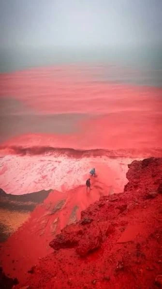
Hormuz Island is one of the most visually remarkable islands in the Persian Gulf. From a distance, it may look like a small, dry island at the entrance to one of the world’s best-known maritime passages. Up close, however, its landscape is a geological palette: red ochre, yellow and orange soils, pale salt formations, dark volcanic-looking rocks, rugged hills, beaches and shallow coastal waters.
The island is best known internationally for its vivid Red Beach, where iron-rich sediments colour the sand and nearby rock faces. After intense rainfall, the effect can become even more dramatic. Fine red soil is washed downslope toward the shore, turning channels, sand and nearshore water shades of crimson against the blue Persian Gulf. Images of this phenomenon often circulate online with sensational descriptions, but the science behind it is both natural and fascinating.
This article introduces Hormuz Island as a geological, cultural and maritime landscape. It explains why the island is called the “Rainbow Island,” how its Red Beach acquired its colour, what happened when heavy rain created the famous crimson runoff, and why responsible appreciation matters for such a fragile place.
Hormuz Island at a glance
| Feature | Overview |
|---|---|
| Location | Iranian island in the Persian Gulf, within the Strait of Hormuz area |
| Province | Hormozgan, Iran |
| Geological character | Salt dome with evaporite, sedimentary and metamorphic materials |
| Famous landscape | Red ochre soils, multicoloured hills, salt caves and striking beaches |
| Signature destination | Red Beach, known for iron-rich red sand and cliffs |
| Maritime setting | Near the strategic waterway connecting the Persian Gulf and Gulf of Oman |
| Ecological feature | A northern mangrove inlet, locally known as a hara forest |
The island is relatively small, but its geological variety is unusually high. That contrast is part of its appeal. In one compact place, visitors can see evidence of ancient salt movement, mineral-rich sediments, coastal erosion and the interaction between an arid climate and the sea.
Where is Hormuz Island—and why does its location matter?
Hormuz Island lies in the Persian Gulf in the wider Strait of Hormuz area, close to the maritime gateway between the Persian Gulf and the Gulf of Oman. The island’s location has given it strategic importance for centuries because this passage is a major route for global maritime trade and energy transport.
For a maritime reader, Hormuz is a reminder that islands can matter for two reasons at once. They can be unique natural environments and they can sit beside intensely used shipping routes. The sea around Hormuz is not an empty horizon. It is part of a working maritime landscape shaped by navigation, ports, fishing, regional trade, coastal communities and international shipping.
That setting makes the island’s quiet geological beauty more striking. The coloured hills and beaches are close to one of the world’s busiest maritime corridors, yet they represent processes that began far earlier than modern navigation or commerce.
Why Hormuz is called the Rainbow Island
Hormuz is often called the “Rainbow Island” because its soils and rocks display a wide range of colours. Reds may grade into orange, yellow, purple, brown, white and grey. The colour is not a painted effect and it is not the result of a single mineral. It comes from a varied geological history and different combinations of minerals, sediments and weathering processes.
NASA Earth Observatory describes Hormuz as a salt dome: a mound of salt, gypsum, anhydrite and other evaporite materials that rose through overlying rock layers. Salt behaves differently from many hard rocks. Under pressure over geological time, it can deform and rise, bringing old materials upward and creating complex surface patterns. The result on Hormuz is a landscape where salt-rich ground, coloured mineral deposits and eroded slopes appear alongside one another.
The red hues that attract the most attention are associated with ochre-rich materials containing iron oxides. Research on the island’s ochre deposits identifies iron-rich, hydrated iron-oxide materials as the source of the distinctive red colour. Different mineral mixtures and degrees of weathering help create the wider range of tones seen across the island.
It is important to understand that the colours are part of the island’s geology, not an unlimited resource for souvenirs. Removing soil or collecting sand may seem harmless when done by one person, but repeated extraction by many visitors can damage fragile surfaces and accelerate erosion. The best way to experience Hormuz is to observe, photograph and learn from it while leaving the landscape in place.
Red Beach: why the sand is red
Hormuz Island’s Red Beach is famous because the colour is so intense. The beach is associated with red, iron-rich soil and cliffs, which can stain the shoreline deep rust, brick red or crimson. The visual contrast between red sediment and the blue waters of the Persian Gulf makes it one of the island’s most recognisable scenes.
The scientific explanation is straightforward. Fine particles in the soil contain iron oxides, including hematite-rich material. These minerals absorb and reflect light in ways that make the ground appear red. When a high concentration of such particles is exposed at the surface, the colour can be vivid even under ordinary dry conditions.
Red Beach is therefore not simply a beach with unusual sand. It is an outdoor geological record. Its colour tells a story about mineral composition, ancient deposits, uplift, erosion and coastal transport. Each rainfall event and each wave can move fine sediment, exposing some surfaces and covering others. The landscape is dynamic even when it appears still.
Hormuz Island’s Red Beach after heavy rainfall: why the water turned crimson
One of the most memorable recent images from Hormuz Island came after heavy rain in December 2025. News footage and reports showed red soil flowing down toward Red Beach and colouring parts of the shoreline and shallow coastal water a vivid crimson. The contrast was dramatic enough for some social-media posts to describe it as a “blood-red sea.” That phrase is visually understandable, but it is not scientifically helpful.
The effect was a natural sediment-runoff event. Heavy rainfall mobilised fine, iron-rich red soil on the slopes and carried it toward the coast. When that soil entered streams, surface channels and the surf zone, suspended particles coloured the water and sand. The sea itself had not permanently changed colour, and the scene was not evidence of an oil spill, a dye release or a harmful algal bloom. It was an unusually vivid expression of the island’s existing mineral geology.
The rainfall event was striking partly because Hormuz has an arid climate and substantial rain is relatively uncommon. When rain does arrive, it can create visible runoff over exposed slopes before the water disperses into the sea. The crimson colour is most intense close to the sources of sediment and in shallow water, where fine particles remain suspended and light reflects from the coloured bed below.
This does not mean every red-looking coastal event anywhere in the world has the same cause. Red water can arise from different processes, including sediment, industrial pollution or biological blooms. The correct approach is to assess the local setting. In the specific case of Hormuz Red Beach, the explanation reported by Associated Press and consistent with the island’s geology was iron-oxide-rich soil washed to the shore by rain.
The event also carries an environmental lesson. A temporary red plume can be natural, but rainfall and runoff still move sediment and reshape exposed ground. Visitors should resist the temptation to walk through sensitive runoff channels, collect wet soil or treat the beach as a stage for disruptive content. The remarkable scene deserves care as well as attention.
The geology beneath the colour
To understand Hormuz, it helps to look below the surface. The island is part of a broader salt-dome landscape in southern Iran. Evaporite materials—especially salt, gypsum and anhydrite—formed in ancient marine settings. Over long periods, pressure caused lower-density salt to move upward through denser overlying rocks in a process often described as salt tectonics or halokinesis.
As salt and associated rocks rose and eroded, they brought a complex mixture of geological materials close to the surface. Weathering, rainfall, wind and coastal processes then shaped the hills, valleys, cliffs and beaches visible today. This helps explain why the island can show such pronounced changes in colour over short distances.
The red ochre deposits have also had economic and cultural significance. Ochre has long been used around the world as a natural pigment. Research on Hormuz notes that its iron-rich ochre has applications in pigment-related industries. That value makes stewardship especially important. Natural heritage can be damaged when extraction, visitor pressure and development are not managed carefully.
For students of geology, geography or environmental science, Hormuz offers a vivid case study of how mineral composition shapes a landscape. For maritime students, it also shows how coastal geology affects beaches, runoff, sediment transport, visual navigation references and the environmental character of a port region.
Salt caves, coloured hills and coastal erosion
Red Beach is only one part of the Hormuz landscape. NASA satellite imagery and field descriptions highlight colourful soils, salt caves, mountains and ochre-stained streams. The attraction is not one isolated feature but the way multiple geological processes appear together on a small island.
Salt-rich formations can create unusual textures, cavities and weathered shapes. Softer materials erode differently from harder layers, creating slopes, ridges and gullies. Rainwater, although infrequent, can cut channels into loose sediment. Wind and sea spray add further weathering. Along the coast, waves redistribute sand and fine particles, making beaches a continually changing boundary between land and sea.
This makes Hormuz visually rich but environmentally sensitive. Foot traffic can disturb loose surfaces. Vehicles can damage fragile ground and create erosion paths. Waste, uncontrolled building and heavy extraction can reduce the very qualities that bring people to the island. Geotourism is most valuable when it supports local communities while protecting the features visitors come to see.
A small island with a living coastal ecosystem
Hormuz is not only coloured rock and sand. NASA Earth Observatory notes a mangrove inlet at the northern end of the island, locally described as a hara forest. Mangroves and associated coastal wetlands can provide habitat for fish, mollusks, crustaceans and migratory birds.
This ecological dimension is easy to overlook when photographs focus only on red soil. Yet the island’s coast includes living systems as well as geological ones. The health of shallow waters, intertidal areas and mangrove habitats depends on sensible management of waste, vessel activity, construction and visitor behaviour.
The connection between land and sea is particularly clear after rain. Surface runoff carries material from hills toward the coastline. In a natural system, sediment movement is part of landscape evolution. But excessive disturbance of soil can increase erosion and place unnecessary pressure on coastal habitats. Protecting Hormuz means respecting both its vivid geology and its marine environment.
Hormuz Island as a cultural and creative landscape
The island’s colour has shaped how people experience and represent it. Ochre and other natural materials have been used as pigments and in local creative expression. The landscapes themselves have become a source of photography, painting, storytelling and environmental-art projects.
However, a responsible cultural narrative should avoid treating the island merely as a backdrop. Hormuz is home to a community with its own daily life, traditions and relationship with the sea. Fishing, local trade, transport, hospitality and art are part of the human landscape. Visitors and online creators should respect residents’ privacy, local customs, access needs and the difference between a lived place and a viral image.
For a website article, that means telling the story with accuracy. The red soil is not magical dye; it is mineral-rich geological material. The Red Beach is not a permanently red ocean; rainfall can temporarily carry fine sediment into shallow water. And the island’s beauty is not separate from responsibility; it depends on protecting the land and coast from unnecessary disturbance.
Responsible ways to experience Hormuz Island
Whether visiting in person or sharing images online, a few simple principles can help protect the island:
- Leave coloured soil and sand where they are. Do not treat geology as a free souvenir supply.
- Stay on established paths and follow local guidance. Loose slopes, salt formations and drainage channels can be fragile.
- Avoid entering runoff channels after rain. They may be unstable, and walking through them can disturb sediment.
- Take waste away and reduce single-use plastics. On islands, waste-management capacity can be limited.
- Respect coastal habitats. Keep distance from mangroves, nesting areas and wildlife.
- Credit the place accurately. Label images as Hormuz Island, Iran, in the Persian Gulf, and avoid sensational explanations that misrepresent the natural process.
These are small actions, but they reflect a larger principle: remarkable landscapes are not renewable in the way photographs are. Once coloured soils, salt formations or habitats are degraded, restoration may be difficult or impossible.
Why Hormuz matters to maritime education
Hormuz Island is a useful subject for maritime education because it connects physical geography with shipping, environmental awareness and coastal-community life. Seafarers navigating the wider Strait of Hormuz operate in a region where routeing, traffic density, weather, coastlines, protected environments and regional regulations all matter.
The island also demonstrates why maritime professionals need environmental literacy. Understanding sediment, runoff, shallow-water colour, dust, visibility and coastal ecology helps engineers, deck officers, port professionals and policymakers interpret what they see. Not every unusual colour at sea is a pollution event, but every unusual event should be assessed carefully rather than assumed to have a single cause.
In the same way, responsible shipping and tourism both depend on respect for coastal environments. The sea is a transport route, a workplace, a food source, a cultural space and an ecological system. Hormuz makes all of those connections visible in one memorable setting.
Frequently asked questions about Hormuz Island and Red Beach
Why is Hormuz Island red?
Parts of Hormuz Island contain iron-rich ochre and other mineral materials. Iron oxides in the soil and rocks produce red, orange and brown colours. Different mineral mixtures create the wider “rainbow” effect across the island.
Did the Persian Gulf really turn red at Hormuz Island after rain?
After heavy rain in December 2025, iron-rich soil runoff coloured parts of Red Beach and nearby shallow water crimson. The effect was temporary and local, caused by suspended red sediment. It did not mean that the whole Persian Gulf had changed colour.
Is Red Beach’s colour caused by pollution?
The red colour at Hormuz Red Beach is primarily natural and related to iron-rich soil. However, unusual colour in any other coastal setting should not automatically be assumed natural; local environmental authorities and scientific evidence are needed to identify the cause.
What is a salt dome?
A salt dome is a geological structure formed when salt and associated evaporite rocks move upward through denser overlying layers over long periods. Hormuz is a salt-dome island, which helps explain its unusual rock types, salt features and colourful terrain.
Why should visitors avoid taking red soil from Hormuz Island?
The coloured soil is part of a fragile geological landscape. Repeated removal by visitors can contribute to erosion and reduce the natural character of the place. The most responsible souvenir is a photograph, not a jar of sand.
Final perspective: a natural phenomenon, not a visual trick
Hormuz Island is remarkable because geology appears so openly at the surface. Its red ochre, salt formations, coloured hills and coastal habitats show how deep geological time meets the present-day Persian Gulf. The Red Beach after heavy rain is one of the clearest examples: a storm mobilises mineral-rich soil, the shoreline turns crimson for a short time, and the island’s hidden chemistry becomes visible.
That is the story worth sharing. Hormuz is neither a fantasy landscape nor a viral curiosity. It is a real island community and a delicate geological environment beside one of the world’s most important maritime corridors. Appreciating it responsibly allows its colour, science and cultural value to remain visible for future visitors, students and coastal communities.