
Few names make an ordinary patch of ocean sound as ominous as the Bermuda Triangle. For generations, books, television programmes and newspaper stories have described a place where compasses fail, weather changes without warning and ships or aircraft vanish without explanation.
Some of those losses were real and remain unresolved. The disappearance of five US Navy aircraft in Flight 19 and the loss of USS Cyclops deserve serious historical attention. But an unsolved accident is not automatically a supernatural event, and the popular Triangle is not an officially defined or statistically exceptional danger zone.
These 12 Bermuda Triangle facts separate the documented record from the stories built around it. The result is still fascinating—just for different reasons.
Quick Answer
The Bermuda Triangle is an informal area of the western North Atlantic, usually imagined between Florida, Bermuda and Puerto Rico. It has no agreed boundary or official geographic status. Ships and aircraft have been lost there, but authorities have found no evidence that disappearances occur more often than in other heavily travelled ocean regions. Weather, tropical cyclones, the Gulf Stream, navigation errors, equipment failures and incomplete historical reporting explain much of the mystery; a few individual cases remain unresolved.
| Fact | What the evidence shows | Common misconception |
|---|---|---|
| Official status | No official boundary or recognised geographic name | It appears as a defined hazard zone on official charts |
| Location | Broadly described between Florida, Bermuda and Puerto Rico | Everyone agrees on its exact size |
| Flight 19 | Five Navy aircraft and 14 airmen disappeared in 1945 | The final radio messages prove a paranormal event |
| USS Cyclops | The ship vanished in 1918 with more than 300 aboard | Its loss has been conclusively explained |
| Weather | Squalls, thunderstorms and tropical cyclones are genuine hazards | Weather alone explains every case |
| Gulf Stream | A powerful current can move debris rapidly | It pulls intact ships underwater |
| Compasses | Magnetic variation is normal and charted | Compasses uniquely malfunction inside the Triangle |
| Traffic | Commercial ships and aircraft cross the region routinely | Transport operators avoid it |
| Human factors | Planning, communication and judgement can compound danger | Experienced crews cannot become disoriented |
| Hurricanes | The western Atlantic is exposed to tropical cyclones | Every famous disappearance occurred in a hurricane |
| Storytelling | Retellings sometimes omit weather or alter details | Every popular version preserves the evidence accurately |
| Lasting appeal | Uncertainty encourages speculation and repetition | Mystery itself is proof of an extraordinary cause |
1. Bermuda Triangle: Myth, Mystery and Maritime Reality
The Bermuda Triangle is best understood as a cultural idea attached to a real ocean region. It combines genuine losses, uncertain evidence, ordinary marine hazards and decades of dramatic storytelling.
The US National Ocean Service says there is no evidence that mysterious disappearances occur more frequently there than in other large, well-travelled parts of the ocean. The US Navy and Coast Guard do not require a supernatural explanation: powerful natural conditions and human fallibility are more than capable of producing maritime and aviation disasters.
That conclusion does not mean every case has been solved. Ocean searches are difficult, particularly before satellite navigation, modern weather observations, emergency beacons and underwater survey technology. Aircraft can sink in deep water, wooden wreckage may break apart, currents can scatter debris and wartime records may be incomplete. “Cause unknown” describes the limits of the evidence; it does not identify a mysterious force.
The most accurate approach is therefore neither credulous nor dismissive. People died in several incidents associated with the legend. Their stories deserve evidence, context and respect—not invented radio messages or sensational claims.
2. Where Is the Bermuda Triangle Located?
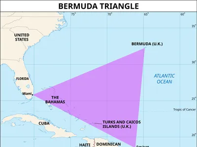
The conventional description places the Triangle in the western North Atlantic, with approximate corners at Miami or the Florida coast, Bermuda and Puerto Rico. Draw those three points on a map and the familiar shape appears.
The problem is that no organisation owns that definition. Different authors have moved the western point north along the US coast, extended the southern boundary into the Caribbean or expanded the area far into the Atlantic. Estimates of its size therefore vary enormously.
The US Board on Geographic Names does not recognise “Bermuda Triangle” as an official geographic name, and no official chart establishes its limits. The lines are a storytelling device, not a legal boundary, meteorological region or navigational exclusion zone.
This matters when counting incidents. If the boundary can expand whenever a convenient accident occurs nearby, the collection becomes impossible to test fairly. A meaningful risk comparison needs a fixed area, a fixed period, traffic exposure and consistent rules about what counts as a disappearance.
3. Flight 19: The Mystery That Made the Triangle Famous
On 5 December 1945, five US Navy TBM Avenger torpedo bombers left Naval Air Station Fort Lauderdale on a routine navigation and bombing training exercise. The formation carried 14 airmen.
Radio communications indicate that the flight became disoriented. The leader, Lieutenant Charles Taylor, apparently believed the formation was over the Florida Keys, while other indications placed it east of Florida. Deteriorating weather, fading daylight, uncertain position and fuel consumption turned a navigation problem into an emergency.
The Avengers never returned, and no confirmed wreckage has been found. A PBM Mariner carrying 13 people also disappeared during the search; a ship reported seeing an airborne explosion in the approximate area, consistent with the aircraft type’s known vulnerability to fuel-vapour fires.
Popular retellings often present selected radio phrases as evidence that instruments behaved impossibly. The surviving communications are fragmentary, however, and the Navy’s historical account emphasises confusion about position rather than an established magnetic anomaly.
Flight 19 remains unresolved because its final location is unknown. The likely chain—navigation error, worsening conditions, fuel exhaustion and ditching at sea—is plausible, but the absent wreckage prevents certainty.
4. USS Cyclops: The Bermuda Triangle’s Biggest Ship Mystery
USS Cyclops was a massive US Navy collier designed to carry coal and other bulk cargo. In early March 1918, during the First World War, it left Barbados for Baltimore carrying manganese ore and more than 300 crew members and passengers.
The ship never arrived. No verified distress call, wreck or debris field has conclusively revealed what happened. Its loss is commonly described by the Naval History and Heritage Command as the largest non-combat loss of life involving a single US Navy ship.
Several ordinary but serious risks were present. The vessel was heavily loaded with dense ore; structural concerns had been reported in this class; one engine was not operating; and weather or sea conditions may have contributed. Investigators have also considered cargo movement, structural failure and sudden capsizing. German attack was investigated, but surviving wartime records have not established it.
The number aboard is reported differently in some sources—often 306 or 309—because historical lists and counting methods vary. A careful article should acknowledge that variation rather than turn a disputed total into false precision.
USS Cyclops is a true maritime mystery. But “unknown” remains the responsible verdict. Atlantis, sea monsters and extraterrestrial intervention add drama without adding evidence.
5. Bermuda Triangle Weather: The Real Danger at Sea
Weather in the western Atlantic can change quickly. Warm ocean water supplies energy and moisture to the atmosphere, while sea-breeze boundaries, tropical disturbances and frontal systems can generate thunderstorms, squalls and sharp wind shifts.
Before modern forecasts and satellite imagery, mariners and pilots had less warning of developing conditions. A rain squall could reduce visibility, obscure the horizon and make visual navigation difficult. Strong downdrafts, turbulence and lightning posed additional threats to aircraft. At sea, wind-driven waves could overwhelm small craft or exploit weaknesses in a larger vessel.
This does not make the region meteorologically supernatural. Forecast centres monitor it using satellites, buoys, radar, aircraft and numerical models. Modern crews receive warnings, plan alternate routes and use redundant navigation systems.
Weather is also not a universal answer. Each accident must be tested against observations available for its time and location. Invoking “a sudden storm” without records is no better than invoking a paranormal force—it substitutes a convenient story for investigation.
6. The Gulf Stream and Bermuda Triangle Disappearances
The Gulf Stream flows northward past Florida before turning northeast into the Atlantic. It is fast, warm and capable of transporting floating material a considerable distance from an accident site.
That movement can complicate search and rescue. Debris, oil, life jackets or a life raft may no longer be near the vessel’s last reported position when rescuers arrive. If a craft sinks into deep water while the surface evidence disperses, a wreck can become exceptionally hard to locate.
The current can also interact with wind and waves. When strong winds oppose a current, seas may become steeper and more closely spaced, increasing the danger to smaller vessels. These are recognised oceanographic effects, not a mysterious suction mechanism.
The Gulf Stream does not open a portal or drag sound ships into the depths. It is one practical reason why an accident can leave little evidence where searchers first expect to find it.
Did you know? A missing wreck is not the same as a wreck with no natural explanation. Deep water, uncertain coordinates, current-driven drift and limited search technology can keep accident sites hidden for decades.
7. Compass Myths in the Bermuda Triangle
A magnetic compass points towards magnetic north, not automatically towards the geographic North Pole. The angle between magnetic north and true north is called magnetic declination or variation. Navigators apply the local correction shown on charts and update it because Earth’s magnetic field changes over time.
Places where magnetic and true north align lie on an agonic line. Such alignment is not unique to the Bermuda Triangle, and the line itself shifts. Older stories sometimes transformed this normal navigational fact into the claim that compasses behave uniquely inside the region.
Compasses can certainly give trouble. Nearby metal, electrical equipment, poor calibration, instrument damage or pilot interpretation can create errors. Aviation and marine navigation therefore use checks, redundancy and procedures rather than trusting one indication blindly.
NOAA reports no evidence of unusual magnetic anomalies that explain the Triangle legend. The danger comes from misunderstanding an instrument or losing situational awareness—not from a special force that makes every compass spin.
8. Why Ships and Planes Still Cross the Bermuda Triangle
Ships and aircraft continue to cross the supposed Triangle because it contains ordinary, economically important routes. Florida connects the continental United States with the Bahamas and Caribbean. Puerto Rico is a major population and transport centre. Bermuda sits along transatlantic and regional passages.
Cruise ships, container vessels, naval ships, private boats and commercial aircraft operate throughout the region. They use traffic services, weather forecasts, electronic charts, radar, satellite navigation and established safety procedures.
An officially recognised exceptional hazard would influence route planning, navigation warnings, regulation and operational risk assessment. Instead, authorities treat the area according to its actual conditions: tropical weather, reefs, currents, busy traffic and open-ocean exposure.
Routine crossings rarely become stories. That creates a powerful perception bias. Millions of safe journeys disappear into the background, while a handful of memorable losses are repeated for generations.
9. Human Error and the Bermuda Triangle Mystery
“Human error” should not be used as a lazy accusation against a dead captain or pilot. In safety investigation, human factors include workload, fatigue, communication, training, equipment design, organisational pressure, ambiguous information and group decision-making.
A crew can begin with a small mistake—an incorrect position, an unnoticed weather change or a misread instrument—and then reinforce it. Under stress, people may cling to an initial belief, disregard conflicting evidence or delay a necessary course change. Fuel limits and worsening conditions eventually remove the chance to recover.
Flight 19 illustrates this kind of escalation. The issue was not that trained aviators lacked basic knowledge. They faced conflicting assumptions about location, incomplete radio communication and a narrowing window before darkness and fuel exhaustion.
Modern maritime and aviation safety tries to interrupt such chains through checklists, bridge and cockpit resource management, standard phraseology, voyage planning, distress beacons and independent cross-checks. These lessons are more useful than blaming a “curse.”
10. Hurricanes and Storms in the Bermuda Triangle
The tropical North Atlantic, Caribbean and waters near the Bahamas are exposed to tropical storms and hurricanes. These systems can bring destructive winds, extreme rainfall, storm surge, large waves and rapidly changing conditions across an enormous area.
The official Atlantic hurricane season runs from 1 June to 30 November, although storms can form outside those dates. Bermuda, Florida, the Bahamas and Puerto Rico have all experienced major tropical cyclones.
Hurricanes provide a credible context for some maritime losses, especially before systematic observation and forecasting. They do not explain every famous Triangle case: Flight 19 disappeared in December, and the record for USS Cyclops does not establish a hurricane as its cause.
Other hazards include ordinary gales, fronts, thunderstorms, waterspouts and occasionally extreme waves. NOAA defines rogue waves as unusually large waves—more than twice the height of surrounding waves—that can arrive unexpectedly. Their existence is real, but assigning one to an old disappearance without evidence remains speculation.
11. Bermuda Triangle Stories: Facts vs. Exaggeration
The modern legend developed through magazines, books and broadcast entertainment. Writer Vincent Gaddis used the phrase “Bermuda Triangle” in a 1964 magazine article, and later bestselling accounts helped turn a loose collection of incidents into a global mystery.
Storytellers sometimes strengthened the pattern by:
- including incidents that occurred outside a chosen boundary;
- omitting storms or known mechanical problems;
- changing dates, routes or crew experience;
- treating a delayed vessel as permanently vanished;
- repeating unsourced radio quotations;
- counting a disappearance without comparing it with traffic volume; and
- presenting “no wreck found” as proof of an extraordinary cause.
Author Larry Kusche’s archival research in the 1970s became influential because he checked original reports, weather records and contemporary newspapers rather than relying on earlier mystery books. He found that many celebrated versions had lost important context in retelling.
Scepticism does not require pretending that every detail is known. It means ranking claims according to the quality of their evidence.
12. Why the Bermuda Triangle Still Fascinates the World
The Triangle endures because it combines three ingredients people find irresistible: the scale of the ocean, the possibility of sudden disappearance and the absence of a final answer.
It also has a memorable name and shape. A “triangle” suggests a bounded mechanism even though the boundaries were never official. Once incidents are placed inside that shape, unrelated events begin to feel connected. Repetition then gives the collection the appearance of a long-established category.
The legend reflects changing technology too. A vanished radio signal was especially haunting in an era when searchers could not track every aircraft by satellite or locate every distress beacon. Today, sonar and autonomous underwater vehicles sometimes find wrecks long thought lost, reminding us that mysteries can survive because the search area is vast—not because nature’s laws failed.
The responsible conclusion is compelling enough: the sea is powerful, evidence is fragile and people create stories to fill gaps in knowledge. The Bermuda Triangle tells us as much about human imagination as it does about the Atlantic Ocean.
–
Frequently Asked Questions
Is the Bermuda Triangle real?
It is real as a popular name for part of the western North Atlantic. It is not an officially defined geographic region or a special hazard zone recognised on official maps.
Where are the three points of the Bermuda Triangle?
The usual points are Florida—often Miami—Bermuda and Puerto Rico. Different writers draw different boundaries, so there is no single accepted area.
Do more ships and planes disappear there?
NOAA states that there is no evidence mysterious disappearances occur more frequently there than in other large, heavily travelled ocean areas. Fair comparison would also need to account for the amount of traffic.
Was Flight 19 ever found?
No confirmed wreckage of the five Avengers has been identified. The formation disappeared on 5 December 1945 after becoming disoriented during a training flight.
What happened to USS Cyclops?
Its exact fate is unknown. The ship vanished after leaving Barbados in March 1918 while carrying manganese ore. Structural failure, loading, machinery and sea conditions have been considered, but no wreck has confirmed a cause.
Do compasses fail in the Bermuda Triangle?
There is no evidence of a unique regional effect that makes compasses fail. Normal magnetic declination, calibration problems, interference and interpretation errors can affect navigation anywhere.
Can the Gulf Stream make wreckage disappear?
It can rapidly carry floating debris away from an accident location and complicate searches. It does not make matter vanish or pull intact vessels underwater.
Are methane bubbles responsible for the disappearances?
Large gas releases can affect water density under particular conditions, but no credible evidence connects such an event to the classic Bermuda Triangle cases. It remains a speculative explanation, not an established cause.
Is it safe to travel through the Bermuda Triangle?
Commercial ships and aircraft cross the area routinely. Travellers face the normal risks of western Atlantic operations, managed through forecasting, navigation, maintenance, regulation and professional procedures.
Conclusion
The best-known Bermuda Triangle facts lead away from the supernatural and towards a richer story. The region has no agreed boundary. It is not recognised as an official geographic feature. Traffic crosses it every day, and available evidence does not show an exceptional rate of mysterious disappearance.
At the same time, Flight 19 and USS Cyclops remain poignant, unresolved losses. Weather, currents, deep water, imperfect navigation and the limits of historical searches can explain why evidence is scarce without pretending to know exactly what happened.
The Triangle’s real lesson is not that the ocean breaks the laws of nature. It is that risk, uncertainty and storytelling can combine to make ordinary geography feel extraordinary.
Continue exploring: Read our guides to famous ship accidents, historic vessels and maritime captains to see how investigation, navigation and leadership have shaped safety at sea.
About the Authors
This article was prepared for an educational maritime-history series. It draws on official naval, oceanographic and meteorological sources and distinguishes documented facts, plausible explanations and unresolved evidence. Dates, casualty figures and technical claims were checked against the references below.
References
- NOAA National Ocean Service — What is the Bermuda Triangle?
- US Naval History and Heritage Command — The Disappearance of Flight 19
- US Naval History and Heritage Command — USS Cyclops
- NOAA National Ocean Service — How Fast Is the Gulf Stream?
- NOAA National Ocean Service — What Is a Rogue Wave?
- NOAA National Hurricane Center — Tropical Cyclone Climatology
- NOAA National Centers for Environmental Information — Geomagnetism Frequently Asked Questions
- Kusche, Lawrence David. The Bermuda Triangle Mystery—Solved. Harper & Row, 1975.