
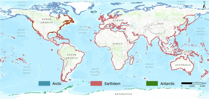
Canada has the longest coastline of any country on Earth—but there is no single, perfectly exact length for it or any other coast.
Coastlines twist around bays, islands, fjords, estuaries and rocky headlands. The more closely they are measured, the more detail appears and the longer the result becomes. This is known as the coastline paradox.
For comparison, most figures below use the widely cited values formerly published by the CIA World Factbook and reproduced in a Food and Agriculture Organization dataset.[1] The CIA retired the World Factbook in February 2026, so these figures should be understood as a legacy comparative dataset—not annual estimates that change each year.[2]
Iran is presented with a broader national estimate of more than 5,800 km because this measure includes its Caspian Sea, Persian Gulf, Gulf of Oman and island shores.[8] It is clearly labelled so that it is not confused with the older World Factbook value, which listed 2,440 km of southern sea coast and placed another 740 km along the Caspian Sea in a separate note.[9]
Greenland would appear near the top of lists that include territories, but it is excluded here because it is an autonomous territory within the Kingdom of Denmark rather than a sovereign country.
12 Extensive and Strategically Important National Coastlines
| No. | Country | Coastline | Main adjoining waters |
| 1 | Canada | 202,080 km | Atlantic, Arctic and Pacific oceans |
| 2 | Indonesia | 54,716 km | Indian and Pacific oceans; regional seas and straits |
| 3 | Russia | 37,653 km | Arctic and Pacific oceans; Baltic and Black seas |
| 4 | Philippines | 36,289 km | Philippine Sea, South China Sea, Sulu and Celebes seas |
| 5 | Japan | 29,751 km | Pacific Ocean, Sea of Japan, Sea of Okhotsk and East China Sea |
| 6 | Australia | 25,760 km | Indian, Pacific and Southern oceans |
| 7 | Norway | 25,148 km | North Atlantic, Norwegian, North and Barents seas |
| 8 | United States | 19,924 km | Atlantic, Pacific and Arctic oceans; Gulf of Mexico |
| 9 | New Zealand | 15,134 km | South Pacific Ocean and Tasman Sea |
| 10 | China | 14,500 km | Yellow, East China and South China seas |
| 11 | Greece | 13,676 km | Aegean, Ionian and Mediterranean seas |
| 12 | Iran | 5,800 km* | Caspian Sea, Persian Gulf, Strait of Hormuz and Gulf of Oman(Mokran) |
* Iran’s value is a broader national estimate that includes island and detailed coastal shores.
Why Coastline Length Is Difficult to Measure
A straight border can be measured with relatively little ambiguity. A natural coast is different. It contains irregular features at many scales—from large gulfs to tiny inlets and rocks.
If a mapmaker uses long measuring segments, small features are skipped. If the same coast is measured with shorter segments, more curves are included and the total rises. Benoît Mandelbrot’s landmark 1967 paper described how geographical curves can display this scale-dependent, fractal-like behaviour.[3]
Published coastline totals can also differ because datasets make different choices about:
- The scale and resolution of the map
- Whether islands, islets and rocks are included
- Whether estuaries and tidal rivers are followed inland
- Whether fjords are measured in full
- Which tidal level defines the shore
- Whether overseas territories are included
- How disputed areas are treated
This is why a ranking should always name its data source and avoid presenting coastline figures as exact physical constants.
1. Canada — 202,080 km
Canada ranks first by a very large margin. Its coast reaches the Atlantic Ocean in the east, the Pacific in the west and the Arctic Ocean in the north.
Much of that length comes from the Canadian Arctic Archipelago, where thousands of islands, channels, bays and inlets create an exceptionally complex shoreline. The Atlantic provinces and British Columbia add further island-rich and deeply indented coasts.
Canada’s long coast supports major ports, fisheries, Indigenous and northern communities, marine conservation, offshore industries and extensive search-and-rescue responsibilities. Arctic ice, remoteness and severe weather also make navigation and emergency response particularly demanding.
The Government of Canada now commonly describes its ocean coastline as more than 243,000 km.[4] The lower 202,080 km figure is retained in this article solely to preserve consistency with the comparative ranking dataset.
Maritime significance: Access to three oceans gives Canada Atlantic, Pacific and Arctic maritime gateways, although large northern sections remain remote and seasonally ice-affected.
2. Indonesia — 54,716 km
Indonesia is the highest-ranked archipelagic country in this dataset. Its thousands of islands stretch between the Indian and Pacific oceans and are separated by a dense network of seas, channels and straits.
This geography creates an enormous coastline relative to the country’s land area. It also places Indonesia beside some of the world’s most important shipping corridors, including the Malacca, Sunda and Lombok routes.
Coastal transport is essential for connecting communities and moving cargo between islands. At the same time, Indonesia must manage busy shipping lanes, fishing activity, port development, marine pollution risks, coral reefs, mangroves and exposure to earthquakes, tsunamis and volcanic hazards.
Maritime significance: Indonesia’s position between two oceans makes it a central state in Southeast Asian shipping and archipelagic navigation.
3. Russia — 37,653 km
Russia’s coast extends across an extraordinary range of climates. It faces the Arctic Ocean across its northern frontier and the Pacific in the east, while also reaching the Baltic and Black seas.
Its Arctic coastline forms the southern side of the Northern Sea Route. Navigation there depends heavily on seasonal ice conditions, ice-class ships, icebreaker support, hydrographic information and specialised polar operating procedures.
Russia’s Pacific coast supports access to Northeast Asia, while Baltic and Black Sea ports connect different parts of the country to regional and international trade routes.
Maritime significance: Russia combines one of the world’s longest Arctic coastlines with access to several strategically distinct maritime regions.
4. Philippines — 36,289 km
The Philippines consists of thousands of islands in the western Pacific. Its highly fragmented geography produces a coastline almost as long as Russia’s in the comparative dataset.
The country borders the Philippine Sea, South China Sea, Sulu Sea and Celebes Sea. Ferries, coastal shipping and domestic ports are therefore vital for passenger travel, food supply and trade between islands.
The same geography creates major safety and environmental challenges. The Philippines is exposed to tropical cyclones, storm surges, coastal flooding and seismic hazards. Protecting coral reefs, mangroves and fishing grounds is closely connected to the safety and livelihoods of coastal communities.
Maritime significance: Inter-island transport is part of the country’s everyday economic and social infrastructure, not simply an international trade activity.
5. Japan — 29,751 km
Japan is another island country whose coastline is much longer than its north-to-south distance might suggest. Its four main islands are surrounded by many smaller islands, bays and peninsulas.
The country faces the Pacific Ocean, Sea of Japan, Sea of Okhotsk and East China Sea. These waters support major container, automotive, energy and fishing activities.
Japan’s coastal cities and industrial zones have shaped its development as a leading maritime and shipbuilding nation. Its ports must also prepare for earthquakes, tsunamis, typhoons and rising coastal risks.
Maritime significance: Japan’s economy, energy supply, shipbuilding sector and international trade are deeply dependent on secure maritime transport.
6. Australia — 25,760 km
Australia is both a country and a continent, surrounded by the Indian, Pacific and Southern oceans. Long beaches may dominate its popular image, but the national coast also includes cliffs, reefs, mangroves, estuaries, gulfs and thousands of islands.
The 25,760 km value comes from the common comparative dataset. Geoscience Australia, using nationally uniform mapping at a scale of 1:100,000, reports a much larger total of 59,681 km when mainland and island coastlines are combined.[6]
This difference does not mean one figure is automatically wrong. It demonstrates how map scale, island inclusion and measurement rules change the result.
Australia’s ports are essential for exports of minerals, energy and agricultural products. Large distances between coastal population centres also create demanding responsibilities for environmental monitoring, border management and maritime search and rescue.
Maritime significance: Australia’s sea-dependent trade connects a resource-rich continent to Asian and global markets.
7. Norway — 25,148 km
Few countries illustrate the coastline paradox better than Norway. Its coast contains deep fjords, offshore islands, skerries, narrow channels and countless rocky indentations.
The comparative dataset gives Norway 25,148 km and therefore places it seventh. However, Statistics Norway reports 83,281 km for the Norwegian mainland when islands, fjords and bays are counted.[5] Rankings that use that national figure often place Norway second behind Canada.
Norway’s coast supports fisheries, aquaculture, offshore energy, passenger ferries, coastal communities and an advanced maritime cluster. The sheltered coastal route also allows ships to travel through many protected waters despite the exposed North Atlantic environment beyond.
Maritime significance: Norway’s fjords and islands create both natural harbours and complex navigation, supporting a strong shipping and marine-technology sector.
8. United States — 19,924 km
The United States has coastlines on the Atlantic and Pacific oceans, the Gulf of Mexico and, through Alaska, the Arctic Ocean. Hawaii and other islands add further Pacific coastline.
Alaska contributes a major share because of its size, islands, bays and deeply indented shore. The contiguous states contain some of the world’s busiest port regions, including gateways serving both the Atlantic and Pacific trades.
Different U.S. agencies may publish much larger “shoreline” figures because they include tidal shorelines around islands, bays and estuaries at finer levels of detail. Such totals should not be mixed directly with the values in this ranking.
Maritime significance: The country’s multiple ocean fronts support international shipping, naval operations, offshore energy, fisheries and extensive domestic coastal trade.
9. New Zealand — 15,134 km
New Zealand’s two main islands, smaller offshore islands, peninsulas, sounds and fjords create a long and varied coast. The country lies in the South Pacific, with the Tasman Sea separating it from Australia.
No part of the main islands is extremely far from the sea, so maritime culture and coastal weather strongly influence daily life. Ports connect the country’s export industries with distant markets, while ferries provide a vital link across Cook Strait.
The coast includes sandy beaches, volcanic shores, high cliffs and the deeply cut fiords of the southwest. Earthquakes, tsunamis, erosion and severe weather all affect coastal planning.
Maritime significance: New Zealand’s geographic isolation makes dependable ports and ocean shipping essential to its economy.
10. China — 14,500 km
China’s sea coast stretches along the Yellow Sea, East China Sea and South China Sea. Major river deltas and broad coastal plains have supported the growth of large cities, ports and industrial areas.
Shanghai, Ningbo-Zhoushan, Shenzhen and other gateways form part of a dense maritime logistics network serving domestic manufacturing and international trade. Coastal shipping also connects industrial regions along the country’s eastern seaboard.
Although China’s coastline is shorter than those of many island states, its concentration of ports, population and industry gives it exceptional maritime economic importance.
Maritime significance: Coastline length alone does not determine shipping power—port capacity, industrial output, hinterland connections and trade flows can matter far more.
11. Greece — 13,676 km
Greece has the longest coastline in the Mediterranean region within this dataset. Its mainland is highly indented, and its many inhabited and uninhabited islands add extensive shores across the Aegean and Ionian seas.
Ferries are essential for connecting islands with the mainland. Tourism, fishing, coastal communities and commercial shipping all depend on the surrounding sea.
The port of Piraeus provides a major connection between Mediterranean routes and European markets. Greece’s geography has also helped shape one of the world’s best-known seafaring traditions.
Maritime significance: Greece combines a long island-rich coastline with a globally important shipping community and strategic position in the eastern Mediterranean.
12. Iran — More Than 3,180 km
Iran has two geographically separate coastal regions. In the north, it borders the Caspian Sea. In the south, its coast extends along the Persian Gulf, around the Strait of Hormuz and eastward beside the Gulf of Oman toward Pakistan.
Iranian sources use several coastline figures because they count different features. The legacy World Factbook listed 2,440 km of sea coastline and mentioned approximately 740 km along the landlocked Caspian Sea separately.[9] A broader figure reported by Iran’s Ports and Maritime Organization is more than 5,800 km, covering the Persian Gulf, Gulf of Oman, Caspian Sea and island shores.[8]
Iran has numerous islands in the Persian Gulf and Strait of Hormuz. They include Qeshm—the largest island in the Persian Gulf—Kish, Hormuz, Kharg, Lavan, Hengam, Larak, Siri, Abu Musa and the Greater and Lesser Tunbs. Iran’s official tourism portal states that the country has the largest number of islands in the Persian Gulf.[10]
The southern coast contains major commercial and energy facilities, including Bandar Imam Khomeini, Bushehr, Bandar Abbas, Shahid Rajaee, Assaluyeh and Chabahar. Qeshm, Hormuz, Larak and Hengam lie around the Strait of Hormuz, while Kharg serves as an important oil-export location.
Iran’s maritime importance is not explained by coastline length alone. Its coast occupies the entire northern side of the Persian Gulf and Strait of Hormuz and continues along the Gulf of Oman, giving the country direct access to the wider Indian Ocean. Northern ports such as Bandar Anzali and Amirabad also connect Iran with the other Caspian littoral states and the International North–South Transport Corridor.
Maritime significance: Iran connects the Caspian region with the Persian Gulf and Indian Ocean while occupying a central position beside the Strait of Hormuz, one of the world’s most consequential maritime passages.
What Does a Long Coastline Mean for a Country?
A long coast can create major opportunities, but it does not guarantee maritime success.
More access to marine resources
Coastal states may develop fisheries, aquaculture, offshore energy, tourism and marine research. Actual rights depend on maritime boundaries and international law—not simply on the physical length of the shore.
More ports and transport options
Bays, estuaries and sheltered waters can provide locations for ports. However, suitable depth, safe access, hinterland connections and cargo demand are more important than coastline length alone.
Greater safety and environmental responsibilities
Long coasts require navigation aids, hydrographic surveying, pollution response, search and rescue, coastal monitoring and protection of marine ecosystems.
Greater exposure to coastal hazards
Storm surges, tsunamis, erosion, sea-level rise, flooding and extreme weather can affect long stretches of coast and many communities.
A coastline is not the same as an EEZ
An exclusive economic zone is measured from legally defined baselines and may extend up to 200 nautical miles, subject to neighbouring states and maritime delimitation.[7] A country with a long coastline does not automatically have the world’s largest EEZ.
–
Frequently Asked Questions
Which country has the longest coastline in the world?
Canada has the world’s longest national coastline. The exact published length varies by method, but both comparative and Canadian government sources place it clearly first.
Why do coastline figures differ between sources?
Results depend on map scale, measurement resolution and whether islands, fjords, estuaries and small coastal features are included. A more detailed measurement generally produces a longer total.
Why is Greenland not included in this ranking?
Greenland is geographically part of North America but politically an autonomous territory within the Kingdom of Denmark. This article ranks sovereign countries, so Greenland is excluded.
Is Iran the country with the world’s 12th-longest coastline?
Not under the uniform legacy dataset. Iran is included here because the broader Iranian estimate exceeds 5,800 km when the Caspian Sea and island shores are counted, and because its position beside the Persian Gulf, Strait of Hormuz and Gulf of Oman gives its coast exceptional maritime importance. Several countries omitted from this selected list have longer legacy coastline figures.
Does Norway have the second-longest coastline?
It can rank second when detailed Norwegian national measurements are used. In the consistent comparative dataset used for this article, Norway is seventh at 25,148 km. Statistics Norway gives 83,281 km when islands, fjords and bays are counted.[5]
Does the longest coastline mean the largest maritime territory?
No. Maritime zones are calculated from legal baselines and affected by neighbouring states, islands and boundary agreements. Coastline length alone does not determine the size of an EEZ or continental shelf.
Is “sea line” the correct geographical term?
Coastline is the standard term for the boundary between land and the sea. Shoreline is also used, often for the more immediate water’s edge. “Sea line” is not the usual English geographical term.
Conclusion
Canada, Indonesia, Russia and the Philippines lead the legacy comparison of countries presented here. Island groups, Arctic archipelagos, fjords and highly indented shores explain why these countries accumulate such large totals.
Iran’s inclusion highlights another important lesson: coastline length and maritime importance are not the same thing. Iran’s broader island-inclusive total is lower than several countries outside this selection, but its position on the Caspian Sea, Persian Gulf, Strait of Hormuz and Gulf of Oman makes it one of the world’s most consequential coastal states.
All figures must still be read with care. A coastline has no single scale-independent length, and national mapping agencies often produce results that differ greatly from international comparison tables. Trustworthy content must therefore identify the measurement method and distinguish strict rankings from selected strategic comparisons.
Explore MaritimEducation for more clear and research-informed articles about maritime geography, ports, shipping routes, oceans, naval architecture and the global marine industry.
About the Authors — MaritimEducation Team
MaritimEducation Team creates clear, practical and research-informed content about ships, marine engineering, maritime education, shipping, ports, technology, safety and sustainability.
References
- Food and Agriculture Organization of the United Nations. EIFAAC Data. Includes 2019 coastline data sourced from the CIA World Factbook and explains the dataset’s coverage.
- Central Intelligence Agency. Spotlighting The World Factbook as We Bid a Fond Farewell. 4 February 2026.
- Mandelbrot, B. B. How Long Is the Coast of Britain? Statistical Self-Similarity and Fractional Dimension. Science, 156(3775), 636–638, 1967. DOI: 10.1126/science.156.3775.636.
- Parks Canada. National Marine Conservation Areas System Plan. Current Canadian government description of the country’s ocean and Great Lakes coastlines.
- Statistics Norway. Construction in the Coastal Zone. National coastline figure including islands, fjords and bays.
- Geoscience Australia. Border Lengths—States and Territories. National coastline calculations from the GEODATA Coast 100K database.
- United Nations, Division for Ocean Affairs and the Law of the Sea. Introduction to Maritime Zones under UNCLOS. Territorial sea, contiguous zone, exclusive economic zone and continental-shelf limits.
- Iran Press. Iran Outlines Maritime Policies, Seeks Investment at IMO Summit. Reports the Iranian Ports and Maritime Organization’s statement that Iran has more than 5,800 km of coastline along the Persian Gulf, Gulf of Oman and Caspian Sea. 26 November 2025.
- Massachusetts Institute of Technology mirror of the CIA World Factbook. Field Listing: Coastline. Legacy entry listing Iran’s 2,440 km coastline and a separate 740 km Caspian Sea shore.
- Iran Ministry of Cultural Heritage, Tourism and Handicrafts. Visit Iran—Overview. National geographic overview and list of major Iranian islands in the Persian Gulf.