

Nautical science is a field of study that involves the theory and practical aspects of navigation, seamanship, ship stability, meteorology, and other related disciplines. It is an essential field for those involved in the operation of ships, including ship captains, officers, and crew members.
Nautical science covers a wide range of topics, including ship construction, marine propulsion systems, and maritime law. It also includes the study of oceanography, which is the scientific study of the ocean and its phenomena. In addition to the technical aspects of navigation and seamanship, nautical science also encompasses soft skills such as leadership, communication, and teamwork. These skills are crucial for the safe and effective operation of ships, particularly in emergency situations. Nautical science is taught in maritime academies and other educational institutions worldwide, with many offering degree programs in the field. Graduates of these programs often go on to work in the maritime industry, including in the commercial shipping sector, naval forces, and research vessels.
Navigation is a field of study that focuses on the process of monitoring and controlling the movement of a vessel or vehicle from one place to another. The field of navigation includes four general categories: land navigation, marine navigation, aeronautic navigation, and space navigation. It is also the term art used for the specialized knowledge navigators use to perform navigation tasks. All navigational techniques involve locating the navigator’s position compared to known locations or patterns. Navigation, in a broader sense, can refer to any skill or study that involves the determination of position and direction.In this sense, navigation includes orienteering and pedestrian navigation.

Table of geography, hydrography, and navigation, from the 1728 Cyclopaedia, or a Universal Dictionary of Arts and Sciences
Most modern navigation relies primarily on positions determined electronically by receivers collecting information from satellites. Most other modern techniques rely on finding intersecting lines of position or LOP. A line of position can refer to two different things, either a line on a chart or a line between the observer and an object in real life. A bearing is a measure of the direction to an object. If the navigator measures the direction in real life, the angle can then be drawn on a nautical chart and the navigator will be somewhere on that bearing line on the chart. In addition to bearings, navigators also often measure distances to objects.On the chart, a distance produces a circle or arc of position.Circles, arcs, and hyperbolae of positions are often referred to as lines of position. If the navigator draws two lines of position, and they intersect he must be at that position.A fix is the intersection of two or more LOPs.If only one line of position is available, this may be evaluated against the dead reckoning position to establish an estimated position.
Lines (or circles) of position can be derived from a variety of sources:
- celestial observation (a short segment of the circle of equal altitude but generally represented as a line),
- terrestrial range (natural or man-made) when two charted points are observed to be in line with each other,
- compass bearing to a charted object,
- radar range to a charted object,
- on certain coastlines, a depth sounding from echo sounder or hand lead line.
There are some methods seldom used today such as “dipping a light” to calculate the geographic range from observer to lighthouse. Methods of navigation have changed through history. Each new method has enhanced the mariner’s ability to complete his voyage. One of the most important judgments the navigator must make is the best method to use. Some types of navigation are depicted in the table.
| Traditional navigation methods include: | ||
|---|---|---|
 |
In marine navigation, Dead reckoning or DR, in which one advances a prior position using the ship’s course and speed. The new position is called a DR position. It is generally accepted that only course and speed determine the DR position. Correcting the DR position for leeway, current effects, and steering error result in an estimated position or EP. An inertial navigator develops an extremely accurate EP. | |
 |
In marine navigation, Pilotage involves navigating in restricted/coastal waters with frequent determination of position relative to geographic and hydrographic features. | |
 |
Land navigation is the discipline of following a route through terrain on foot or by vehicle, using maps with reference to terrain, a compass, and other basic navigational tools and/or using landmarks and signs. Wayfinding is the more basic form. | |
 |
Celestial navigation involves reducing celestial measurements to lines of position using tables, spherical trigonometry, and almanacs. It is primarily used at sea but can also be used on land. | |
| Electronic navigation covers any method of position fixing using electronic means, including: | ||
 |
Radio navigation uses radio waves to determine position by either radio direction finding systems or hyperbolic systems, such as Decca, Omega and LORAN-C. | |
 |
Radar navigation uses radar to determine the distance from or bearing of objects whose position is known. This process is separate from radar’s use as a collision avoidance system. | |
 |
Satellite navigation uses a Global Navigation Satellite System (GNSS) to determine position. | |
The practice of navigation usually involves a combination of these different methods.
History of navigation
The history of navigation is the history of seafaring, the art of directing vessels upon the open sea through the establishment of its position and course by means of traditional practice, geometry, astronomy, or special instruments. Many peoples have excelled as seafarers, prominent among them the Austronesians (Islander Southeast Asians, Malagasy, Islander Melanesians, Micronesians, and Polynesians), the Harappans, the Phoenicians, the Iranians, the ancient Greeks, the Romans, the Arabs, the ancient Indians, the Norse, the Chinese, the Venetians, the Genoese, the Hanseatic Germans, the Portuguese, the Spanish, the English, the French, the Dutch and the Danes.
The Arab Empire significantly contributed to navigation, and had trade networks extending from the Atlantic Ocean and Mediterranean Sea in the west to the Indian Ocean and China Sea in the east,Apart from the Nile, Tigris and Euphrates, navigable rivers in the Islamic regions were uncommon, so transport by sea was very important. Islamic geography and navigational sciences made use of a magnetic compass and a rudimentary instrument known as a kamal, used for celestial navigation and measuring the stars’ altitudes and latitudes. The kamal itself was simple to construct. It was a rectangular piece of either bone or wood with a string with 9 consecutive knots attached to it. Another instrument available, developed by the Arabs as well, was the quadrant. Also a celestial navigation device, it was originally developed for astronomy and later transitioned to navigation.When combined with detailed maps of the period, sailors were able to sail across oceans rather than skirt along the coast. However, there are no records of open ocean Atlantic sailing, and their activity focused on Mediterranean, Red Sea, Persian Gulf, Arabian Sea and across to the Bay of Bengal.Muslim sailors were also responsible for using and developing the lateen sails[citation needed] and large three-masted merchant vessels to the Mediterranean. The origins of the caravel ship, developed and used for long-distance travel by the Portuguese, and later by the rest of Iberians, since the 15th century, also date back to the qarib used by Andalusian explorers by the 13th century.
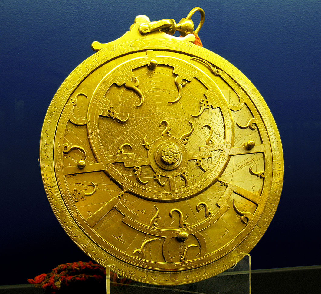
An 18th-century Persian Astrolabe, kept at The Whipple Museum of the History of Science in Cambridge, England.
The sea lanes between India and neighbouring lands were the usual form of trade for many centuries and are responsible for the widespread influence of Indian culture on the societies of Southeast Asia. Powerful navies included those of the Maurya, Satavahana, Chola, Vijayanagara, Kalinga, Maratha and Mughal Empire. Vikings used polarization and the Sunstone to allow navigation of their ships by locating the Sun even in a completely overcast sky. This special mineral was talked about in several 13th – 14th-century written sources in Iceland, some centuries after the carbon-dated, early-11th-century Norse settlement of L’Anse aux Meadows in northernmost Newfoundland had been briefly established. In China between 1040 and 1117, the magnetic compass was being developed and applied to navigation. This let masters continue sailing a course when the weather limited sky visibility. The true mariner’s the compass using a pivoting needle in a dry box was invented in Europe no later than 1300. Nautical charts called portolan charts began to appear in Italy at the end of the 13th century. However, their use did not seem to spread quickly: there were no reports of using a nautical chart on an English vessel until 1489.
Navigation in modern times
In 1714 the British Commissioners for the discovery of longitude at sea came into prominence.This group, which existed until 1828, offered grants and rewards for the solution of navigational problems.Between 1737 and 1828, the commissioners disbursed some £101,000. The government of the United Kingdom also offered significant rewards for navigational accomplishments in this era, such as £20,000 for the discovery of the Northwest Passage and £5,000 for the navigator that could sail within a degree of latitude of the North Pole. A widespread manual in the 18th century was Navigatio Britannica by John Barrow, published in 1750 by March & Page and still being advertised in 1787. Isaac Newton invented a reflecting quadrant around 1699. He wrote a detailed description of the instrument for Edmond Halley, which was published in 1742. Due to this time lapse, credit for the invention has often been given instead to John Hadley and Thomas Godfrey. The octant eventually replaced earlier cross-staffs and Davis quadrants,and had the immediate effect of making latitude calculations much more accurate.
A highly important breakthrough for accurately determining longitude came with the invention of the marine chronometer. The 1714 longitude prize offer for a method of determining longitude at sea, was won by John Harrison, a Yorkshire carpenter. He submitted a project in 1730, and in 1735 completed a clock based on a pair of counter-oscillating weighted beams connected by springs whose motion was not influenced by gravity or the motion of a ship. His first two sea timepieces H1 and H2 (completed in 1741) used this system, but he realised that they had a fundamental sensitivity to centrifugal force, which meant that they could never be accurate enough at sea. Harrison solved the precision problems with his much smaller H4 chronometer design in 1761. H4 looked much like a large five-inch (12 cm) diameter pocket watch. In 1761, Harrison submitted H4 for the £20,000 longitude prize. His design used a fast-beating balance wheel controlled by a temperature-compensated spiral spring. These features remained in use until stable electronic oscillators allowed very accurate portable timepieces to be made at affordable cost. In 1767, the Board of Longitude published a description of his work in The Principles of Mr. Harrison’s time-keeper.
In 1757, John Bird invented the first sextant. This replaced the Davis quadrant and the octant as the main instrument for navigation. The sextant was derived from the octant in order to provide for the lunar distance method. With the lunar distance method, mariners could determine their longitude accurately. Once chronometer production was established in the late 18th century, using the chronometer for accurately determining longitude was a viable alternative.Chronometers replaced lunars in wide usage by the late 19th century.
In 1891 radios, in the form of wireless telegraphs, began to appear on ships at sea. In 1899 the R.F. Matthews was the first ship to use wireless communication to request assistance at sea. Using radio to determine direction was investigated by “Sir Oliver Lodge, of England; Andre Blondel, of France; De Forest, Pickard; Stone, of the United States; and Bellini and Tosi, of Italy.”The Stone Radio & Telegraph Company installed an early prototype radio direction finder on the naval collier Lebanon in 1906. By 1904 time signals were being sent to ships to allow navigators to check their chronometers. The U.S. Navy Hydrographic Office sent navigational warnings to ships at sea by 1907. Later developments included placing lighthouses and buoys close to shore to act as marine signposts identifying ambiguous features, highlighting hazards and pointing to safe channels for ships approaching some part of coast after a long sea voyage. In 1912 Nils Gustaf Dalén was awarded the Nobel Prize in Physics for his invention of automatic valves designed to be used in combination with gas accumulators in lighthouses. 1921 saw the installation of the first radiobeacon. The first prototype shipborne radar system was installed on the USS Leary in April 1937.

A 1943 United States military map of world ocean currents and ice packs, as they were known at the time.
On November 18, 1940, Mr. Alfred L. Loomis made the initial suggestion for an electronic air navigation system which was later developed into LORAN (long range navigation system) by the Radiation Laboratory of the Massachusetts Institute of Technology,and on November 1, 1942, the first LORAN System was placed in operation with four stations between the Chesapeake Capes and Nova Scotia.
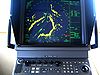
In October 1957, the Soviet Union launched the world’s first artificial satellite, Sputnik. Scientists at Johns Hopkins University’s Applied Physics Laboratory took a series of measurements of Sputnik’s doppler shift yielding the satellite’s position and velocity.This team continued to monitor Sputnik and the next satellites into space, Sputnik II and Explorer I. In March 1958 the idea of working backwards, using known satellite orbits to determine an unknown position on the Earth’s surface began to be explored.This led to the TRANSIT satellite navigation system.The first TRANSIT satellite was placed in polar orbit in 1960. The system, consisting of 7 satellites, was made operational in 1962.A navigator using readings from three satellites could expect accuracy of about 80 feet. On July 14, 1974 the first prototype Navstar GPS satellite was put into orbit, but its clocks failed shortly after launch.The Navigational Technology Satellite 2, redesigned with cesium clocks, started to go into orbit on June 23, 1977.By 1985, the first 11-satellite GPS Block I constellation was in orbit. Satellites of the similar Russian GLONASS system began to be put into orbit in 1982, and the system is expected to have a complete 24-satellite constellation in place by 2010. The European Space Agency expects to have its Galileo with 30 satellites in place by 2011–12 as well.
Navigator
A navigator is the person on board a ship or aircraft responsible for its navigation.The navigator’s primary responsibility is to be aware of ship or aircraft position at all times. Responsibilities include planning the journey, advising the ship’s captain or aircraft commander of estimated timing to destinations while en route, and ensuring hazards are avoided. The navigator is in charge of maintaining the aircraft or ship’s nautical charts, nautical publications, and navigational equipment, and they generally have responsibility for meteorological equipment and communications. With the advent of satellite navigation, the effort required to accurately determine one’s position has decreased by orders of magnitude, so the entire field has experienced a revolutionary transition since the 1990s with traditional navigation tasks, like performing celestial navigation, being used less frequently. Using multiple independent position fix methods without solely relying on electronic systems subject to failure helps the navigator detect errors. Professional mariners are still proficient in traditional piloting and celestial navigation.
Nautical charts
A naval ship’s navigator is responsible for buying and maintaining its nautical charts. A nautical chart, or simply “chart”, is a graphic representation of a maritime or flight region and adjacent coastal regions. Depending on the scale of the chart, it may show depths of water and heights of land, natural features of the seabed, details of the coastline, navigational hazards, locations of natural and man-made aids to navigation, information on tides and currents, local details of the Earth’s magnetic field, restricted flying areas, and man-made structures such as harbors, buildings and bridges. Nautical charts are essential tools for marine navigation; many countries require vessels, especially commercial ships, to carry them. Nautical charting may take the form of charts printed on paper or computerised electronic navigational charts.
The nature of a waterway depicted by a chart changes regularly, and a mariner navigating on an old or uncorrected chart is courting disaster. Every producer of navigational charts also provides a system to inform mariners and aviators of changes that affect the chart. In the United States, chart corrections and notifications of new editions are provided by various governmental agencies by way of Notices to Airmen (NOTAMs), Notice to Mariners, Local Notice to Mariners, Summary of Corrections, and Broadcast Notice to Mariners. Radio broadcasts give advance notice of urgent corrections.
A convenient way to keep track of corrections is with a “chart and publication correction record card” system. Using this system, the navigator does not immediately update every chart in the portfolio when a new Notice to Mariners arrives, instead creating a card for every chart and noting the correction on this card. When the time comes to use the chart, the navigator pulls the chart and chart’s card, and makes the indicated corrections on the chart. This system ensures that every chart is properly corrected prior to use. British merchant vessels receive weekly Notices to Mariners issued by the Admiralty. When corrections are received all charts are corrected in the ship’s folio and recorded in NP133A (Admiralty Chart Correction Log and Folio Index). This system ensures that all charts are corrected and up to date. In a deep-sea vessel with a folio of over three thousand charts this can be a laborious and time-consuming task for the navigator.
Various and diverse methods exist for the correction of electronic navigational charts.
Nautical publications
The term nautical publications is used in maritime circles to describe a set of publications, generally published by national governments, for use in safe navigation of ships, boats, and similar vessels. The nature of waterways described by any given nautical publication changes regularly, and a mariner navigating by use of an old or uncorrected publication is courting disaster. Every producer of nautical publications also provides a system to inform mariners of changes that affect the chart. In the United States, corrections and notifications of new editions are provided by various governmental agencies by way of Notice to Mariners, Local Notice to Mariners, Summary of Corrections, and Broadcast Notice to Mariners. Radio broadcasts give advance notice of urgent corrections. For ensuring that all publications are fully up-to-date, similar methods are employed as for nautical charts. Various and diverse methods exist for the correction of electronic nautical publications.
List of Lights and Radio Signals
List of lights and radio signals, sometimes including Fog Signals are provided by government authorities and hydrographic offices for mariners. The lists include prominent lights, such as lighthouses and radio stations that are used in passage planning for navigation and communication while on voyage. In the US, the United States Coast Guard Light List is an American navigation publication in seven volumes made available yearly by the U.S. Coast Guard which gives information on lighted navigation aids, unlighted buoys, radiobeacons, radio direction finder calibration stations, daybeacons and racons. The List of Lights, Radio Aids, and Fog Signals is a navigation publication produced by the United States Defense Mapping Agency Hydrographic/Topographic Center. The book is usually referred to as the List of Lights, and should not be confused with the U.S. Coast Guard’s Light List. The List of Lights is published in seven volumes, as Publication numbers 110 through 116. Each volume contains lights and other aids to navigation that are maintained by or under the authority of other governments. In the UK, the UKHO List of Lights and Fog Signals, and the Admiralty List of Radio signals are split into separate volumes.[5][6] The UKHO light lists include some 85,000 light structures of significance for navigation.The UKHO radio lists are split into six volumes.The Canadian Coast Guard publishes its own List of Lights, Buoys and Fog Signals covering various coastal geographic areas in Canada.
Pilot Volumes/Sailing Directions
General Reference Publications
The World Port Index
The World Port Index is a US National Geospatial-Intelligence Agency issued a US publication.It contains a tabular listing of thousands of ports throughout the world, describing their location, characteristics, known facilities, and available services. Of particular interest are the applicable volume of Sailing Directions and the number of the harbor chart. The table is arranged geographically, with an alphabetical index. It is also available from several different independent publishers.
Distances Between Ports
Distances Between Ports is a US publication produced by the US Defense Mapping Agency Hydrographic Topographic Center and issued by the National Oceanic and Atmospheric Administration and the United States Department of Commerce.It lists the distances between major ports. Reciprocal distances between two ports may differ due to different routes chosen because of currents and climatic conditions. To reduce the number of listings needed, junction points along major routes are used to consolidate routes converging from different directions. It is also available from several different independent publishers.
Mission and voyage planning
Passage planning procedures are specified in International Maritime Organization Resolutions, in the laws of IMO signatory countries (for example, Title 33 of the U.S. Code of Federal Regulations), and some professional books and USN/USAF publications. There are some fifty elements of a comprehensive passage plan depending on the size and type of vessel, each applicable according to the individual situation.
A good passage plan will include a track line based on the largest-scale charts available, covering the vessel’s track. The navigator will draw and redraw the track line until it is safe, efficient, and in line with all applicable laws and regulations. When the track is finished, it is becoming common practice to also enter it into electronic navigation tools such as an Electronic Chart Display and Information System, a chartplotter, or a GPS unit.
Once the voyage has begun the progress of the vessel along its planned route must be monitored. This requires that the ship’s position be determined, using standard methods including dead reckoning, radar fixing, celestial navigation, pilotage, and electronic navigation, to include usage of GPS and navigation computer equipment.
Passage planning software, tide and tidal current predictors, celestial navigational calculators, consumables estimators for fuel, oil, water, and stores, and other useful applications.
Boats and ships can use several Global Navigation Satellite Systems (GNSS) to navigate all of the world’s lakes, seas and oceans. Maritime GNSS units include functions useful on water, such as “man overboard” (MOB) functions that allow instantly marking the location where a person has fallen overboard, which simplifies rescue efforts. GNSS may be connected to the ships self-steering gear and Chartplotters using the NMEA 0183 interface, and GNSS can also improve the security of shipping traffic by enabling AIS.
e-Navigation
e-Navigation is a strategy developed by the International Maritime Organization (IMO), a UN specialized agency, to bring about increased safety of navigation in commercial shipping through better organization of data on ships and on shore, and better data exchange and communication between ships and the ship and shore. The concept was launched when maritime authorities from seven nations requested the IMO’s Maritime Safety Committee to add the development of an e-navigation strategy to the work programs of the IMO’s NAV and COMSAR sub-committees. Working groups in three sub-committees (NAV, COMSAR and STW) and an intersessional correspondence group, led by Norway, has subsequently developed a Strategy Implementation Plan (SIP). Member states of IMO and a number of Intergovernmental and non-governmental organisations have contributed to the work, including the International Hydrographic Organization (IHO), Comité International Radio-Maritime (CIRM), the International Association of Lighthouse Authorities (IALA), the International Chamber of Shipping (ICS), the Baltic and International Maritime Council (BIMCO) and the International Electrotechnical Commission (IEC).
At MSC 85, the committee, taking into account inputs from the industry and other relevant organizations (e.g., IALA and IHO), approved the strategy for the development and implementation of e-navigation and developed the following definition of e-navigation:
e-navigation is the harmonized collection, integration, exchange, presentation and analysis of marine information on board and ashore by electronic means to enhance berth to berth navigation and related services for safety and security at sea and protection of the marine environment.
The human element, training and harmonization
The last decades have seen huge developments in technology within navigation and communication systems. Sophisticated and advanced technology is developing rapidly. Mariners have never had more technological support systems than today; therefore, there is a need to coordinate systems and more use of harmonised standards. Although ships now carry Global Satellite Navigation Systems (GNSS) and will all have reliable Electronic Chart Displays and Information Systems (ECDIS), their use on board is not fully integrated and harmonised with other existing systems and those of other ships and ashore. At the same time it has been identified that the human element, including training, competency, language skills, workload and motivation, are essential in today’s world. Administrative burden, information overload and ergonomics are prominent concerns. A clear need has been identified for applying good ergonomic principles in a well-structured human machine interface as part of the e-navigation strategy.
e-Navigation benefits for users and stakeholders
On a global level, e-navigation will:
- Standardize bridge design which globally enhances the opportunity to work cross-border, improves efficiency in training and reduces material cost. Similarities between nations and vessels would also increase efficiency and improve safety.
- Reduce barriers to trade through the reduction of local solutions and bureaucracy.
- Reduce the risk of accidents and incidents.
For coastal states, flag states, and port states, e-navigation will:
- Improve efficiency in training, certification and supervision;
- Improve situational awareness by providing easy access to standard and reliable information;
- Improve efficiency in supervision, coordination, control, as well as coordination and information;
- Reduce the risk of accidents and incidents through efficient use of VTS services.
For branches, organizations and industry e-navigation will:
- Provide flexibility with regards to training and rotation as standardization would lead to a more efficient market for standardized bridge products;
- Simplify reporting and thereby reducing the workload for operations;
- Improve safety for own fleet;
- Improve situational awareness for bridge personnel and thereby improving the speed and efficiency of decision making;
- Increase navigational safety in VTS regulated areas;
- Provide a direction for product development to a wide market;
- Provide opportunity for new products and solutions;
For ship-borne users e-navigation will:
- Simplify daily work and training;
- Improve human-machine interface, usability, familiarity and navigational safety;
- Improve time-saving and efficiency on board by providing easier access to information, thereby improving the response time/problem solving abilities of bridge personnel;
- Improved navigational safety by reducing the administrative workload;
- Improve confidence in the use of navigational equipment;
- Enhance the quality, accuracy and reliability of information, thereby improving situational awareness and navigational safety;
- Provide easy access to need-to-know information in a user friendly single window;
- Improve familiarity with systems through standardization;
- Improve service and safety in VTS-regulated areas by providing easy access to available services and warnings
- Reduce bureaucracy and thereby support more efficient use of bridge resources;
- Reduce the risk of accidents;
Vessel traffic service
A vessel traffic service is a marine traffic monitoring system established by harbour or port authorities, similar to air traffic control for aircraft. The International Maritime Organization defines vessel traffic service as “a service implemented by a competent authority designed to improve the safety and efficiency of vessel traffic and protect the environment. The service shall have the capability to interact with the traffic and respond to traffic situations developing in the vessel traffic service area”. Typical vessel traffic service systems use radar, closed-circuit television, VHF radiotelephony and automatic identification system to keep track of vessel movements and provide navigational safety in a limited geographical area. In the United States, the Coast Guard Navigation Center establishes and operates vessel traffic services. Some services operate as partnerships between the Coast Guard and private agencies.
Personnel
Guidelines require that the vessel traffic service authority be provided with sufficient staff, appropriately qualified, suitably trained and capable of performing the required tasks, taking into consideration the type and level of services to be provided in conformity with the current International Maritime Organization guidelines on the subject.International Association of Marine Aids to Navigation and Lighthouse Authorities Recommendation V-103 is the recommendation sn Standards for training and certification of vessel traffic service personnel. Four associated model courses, V103/1 to V-103/4, are approved by the International Maritime Organization and should be used when training personnel for the vessel traffic service qualifications.
Information service
An information service is a service to ensure that essential information becomes available in time for onboard navigational decision-making. The information service is provided by broadcasting information at fixed times and intervals or when deemed necessary by the vessel traffic service or at the request of a vessel, and may include for example reports on the position, identity and intentions of other traffic; waterway conditions; weather; hazards; or any other factors that may influence the vessel’s transit.
Traffic organization service
A traffic organization service is a service to prevent the development of dangerous maritime traffic situations and to provide for the safe and efficient movement of vessel traffic within the vessel traffic service area. The traffic organization service concerns the operational management of traffic and the forward planning of vessel movements to prevent congestion and dangerous situations and is particularly relevant in times of high traffic density or when the movement of special transports may affect the flow of other traffic. The service may also include establishing and operating a system of traffic clearances or sailing plans, or both, concerning priority of movements, allocation of space, mandatory reporting of movements in the service area, routes to be followed, speed limits to be observed or other appropriate measures which are considered necessary by the vessel traffic service authority.
Navigational assistance is a service to assist onboard navigational decision-making and monitor its effects. The navigational assistance service is especially important in difficult navigational or meteorological circumstances or in case of defects or deficiencies. This service is normally rendered at the request of a vessel or by the vessel traffic service when deemed necessary.
Source: Wikipedia
Thanks for sharing. I read many of your blog posts, cool, your blog is very good.
I don’t think the title of your article matches the content lol. Just kidding, mainly because I had some doubts after reading the article.
Your article helped me a lot, is there any more related content? Thanks!
Thanks for sharing. I read many of your blog posts, cool, your blog is very good.