
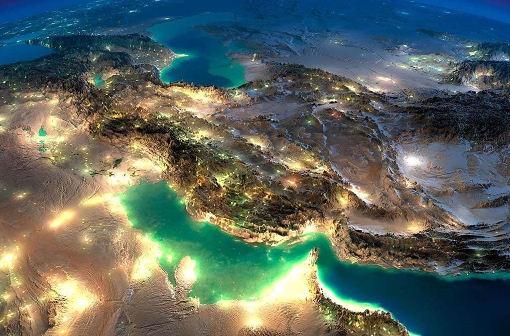
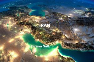
The Persian Gulf (Persian: خلیج فارس, romanized: xalij-e fârs, lit. ‘Gulf of Fars’, pronounced [xæliːdʒe fɒːɾs]), is a mediterranean sea in Western Asia. The body of water is an extension of the Indian Ocean located between Iran and the Arabian Peninsula. It is connected to the Gulf of Oman in the east by the Strait of Hormuz. The Shatt al-Arab river delta forms the northwest shoreline.
The Persian Gulf has many fishing grounds, extensive reefs (mostly rocky but also coral), and abundant pearl oysters, but its ecology has been damaged by industrialization and oil spills.
The Persian Gulf is in the Persian Gulf Basin, which is of Cenozoic origin and related to the subduction of the Arabian Plate under the Zagros Mountains.The current flooding of the basin started 15,000 years ago due to rising sea levels of the Holocene glacial retreat.
الخليج الفارسى هوا ذراع مائيه لبحر العرب بيمتد من خليج عمان جنوب حتى شط العرب فى الشمال بطول 965 كيلومتر. مساحة الخليج الفارسى حوالى 233,100 كيلومتر, و عرضه ما بين حد اقصى حوالى 370 كم لحد ادنى 55 كم فى مضيق هرمز. و الخليج ضحل غماقته مش اكتر 90 متر الا فى شوية اماكن. طول الساحل العربى على الخليج الفارسى 3,490 كيلومتر و هوا اطول من الساحل الايرانى, ساحل ايران طوله 2,440 كيلومتر على الخليج الفارسى
بيفصل الخليج الفارسى شبه الجزيره العربيه و جنوب غرب ايران, و بتطل عليه تمن دول هيا العراقو الكويت و السعوديه و قطر و الامارات و عمان و ايران كمان بتحيط مية بدولة البحرين. بيحده من الشمال و الشرق ايران و من الجنوب الشرقى و الجنوب سلطنة عمان و الامارات العربيه المتحده, وتحده من الجنوب الغربى والغرب كل من المملكه العربيه السعوديه و قطر, وتقع كل من الكويت والعراق على اطرافه الشمال غربيه, بينما تقع البحرين ضمن مياه الخليج الغربيه شمال قطر.
و المنطقه بتلعب دور مهم على الصعيد العسكرى, و الاقتصادى, و السياسى, كتير من ناقلات النفط بتعبر من خلاله عبر الموانئ النفطيه على سواحله لان اغلب البلدان اللى بتطل على سواحله هيا مصدره للنفط, اضافه لداه مياهه بتضم حقول نفطيه و غازيه, و هوا من اكتر الممرات المائيه حسب الازدحام فى العالم.
|
Persian Gulf from space
|
|
| Location | Western Asia |
|---|---|
| Coordinates | 26°N 52°ECoordinates: 26°N 52°E |
| Type | Gulf |
| Primary inflows | Gulf of Oman |
| Basin countries | Iran, Iraq, Kuwait, Saudi Arabia, Qatar, Bahrain, United Arab Emirates and Oman (the exclave of Musandam) |
| Max. length | 989 km (615 mi) |
| Surface area | 251,000 km2 (97,000 sq mi) |
| Average depth | 50 m (160 ft) |
| Max. depth | 90 m (300 ft) |

Geography
The International Hydrographic Organization defines the Persian Gulf’s southern limit as “The Northwestern limit of Gulf of Oman”. This limit is defined as “A line joining Ràs Limah (25°57’N) on the coast of Arabia and Ràs al Kuh (25°48’N) on the coast of Iran (Persia)”. This inland sea of some 251,000 square kilometres (96,912 sq mi) is connected to the Gulf of Oman in the east by the Strait of Hormuz; and its western end is marked by the major river delta of the Shatt al-Arab, which carries the waters of the Euphrates and the Tigris. In Iran, this is called “Arvand Rood”, where “Rood” means “river”. Its length is 989 kilometres (615 miles), with Iran covering most of the northern coast and Saudi Arabia most of the southern coast. The Persian Gulf is about 56 km (35 mi) wide at its narrowest, in the Strait of Hormuz. Overall, the waters are very shallow, with a maximum depth of 90 metres (295 feet) and an average depth of 50 metres (164 feet).
Countries with a coastline on the Persian Gulf are (clockwise, from north): Iran; Oman’s Musandam exclave; the United Arab Emirates; Saudi Arabia; Qatar, on a peninsula off the Saudi coast; Bahrain, an island nation; Kuwait; and Iraq in the northwest. Various small islands also lie within the Persian Gulf, some of which are the subject of territorial disputes between the states in the region.
Exclusive economic zone
Exclusive economic zones in the Persian Gulf:
| Number | Country | Area (km2) |
|---|---|---|
| 1 | 97,860 | |
| 2 | 52,455 | |
| 3 | 33,792 | |
| 4 | 31,819 | |
| 5 | 11,786 | |
| 6 | 8,826 | |
| 7 | 3,678 | |
| 8 | 540 | |
| Total | Persian Gulf | 240,756 |
Coastlines
Countries by coastline length:
| Number | Country | Length |
|---|---|---|
| 1 | 1,536 | |
| 2 | 1,300 | |
| 3 | 900 | |
| 4 | 563 | |
| 5 | 499 | |
| 6 | 161 | |
| 7 | 100 | |
| 8 | 58 | |
| Total | Persian Gulf | 5,117 |
Islands
The Persian Gulf is home to many islands, such as Bahrain, an Arab state. Geographically, the biggest island in the Persian Gulf is Qeshm island, belonging to Iran and located in the Strait of Hormuz. Other significant islands in the Persian Gulf include Greater Tunb, Lesser Tunb and Kish administered by Iran, Bubiyan administered by Kuwait, Tarout administered by Saudi Arabia, and Dalma administered by UAE. In recent years, artificial islands have been added for tourist attractions, such as The World Islands in Dubai and The Pearl-Qatar in Doha. Persian Gulf islands are often also historically significant, having been used in the past by colonial powers such as the Portuguese and the British in their trade or as acquisitions for their empires.
Oceanography
The Persian Gulf is connected to the Indian Ocean through the Strait of Hormuz. Writing the water balance budget for the Persian Gulf, the inputs are river discharges from Iran and Iraq (estimated to be 2,000 cubic metres (71,000 cu ft) per second), as well as precipitation over the sea, which is around 180 mm (7.1 in)/year in Qeshm Island. The evaporation of the sea is high so after considering river discharge and rain contributions, there is still a deficit of 416 cubic kilometres (100 cu mi) per year. This difference is supplied by currents at the Strait of Hormuz. The water from the Persian Gulf has a higher salinity and therefore exits from the bottom of the Strait, while ocean water with less salinity flows in through the top. Another study revealed the following numbers for water exchanges for the Persian Gulf: evaporation = –1.84 m (6.0 ft)/year, precipitation = 0.08 m (0.26 ft)/year, inflow from the Strait = 33.66 m (110.4 ft)/year, outflow from the Strait = -32.11 m (105.3 ft)/year, and the balance is 0 m (0 ft)/year. Data from different 3D computational fluid mechanics models, typically with a spatial resolution of 3 kilometres (1.9 mi) and depth each element equal to 1–10 metres (3.3–32.8 ft) are predominantly used in computer models.
Name

Map of the Persian Gulf. The Gulf of Oman leads to the Arabian Sea.
In 550 BC, the Achaemenid Empire established the first ancient empire in Persis (Pars, or modern Fars), in the southwestern region of the Iranian plateau.[Consequently, in the Greek sources, the body of water that bordered this province came to be known as the “Persian Gulf”.In the book of Nearchus known as The Indikê (300 BC), the word “Persikon kaitas” is mentioned for multiple times meaning “Persian gulf”.
During the years 550 to 330 BC, coinciding with the sovereignty of the Achaemenid Persian Empire over the Middle East area, especially the whole part of the Persian Gulf and some parts of the Arabian Peninsula, the name of “Pars Sea” is widely found in the compiled written texts.
In the travel account of Pythagoras, several chapters are related to the description of his travels accompanied by the Achaemenid king Darius the Great, to Susa and Persepolis, and the area is described. From among the writings of others in the same period, there is the inscription and engraving of Darius the Great, installed at the junction of waters of Red Sea and the Nile river and the Rome river (current Mediterranean), which belongs to the fifth century BC where Darius the Great has named the Persian Gulf Water Channel: “Pars Sea” (“Persian Sea”). King Darius says:
I ordered to dig this (Suez) canal from the river that is called Nile and flows in Egypt, to the sea that begins in Pars. Therefore, when this canal had been dug as I had ordered, ships went from Egypt through this canal to Pars, as I had intended.
— Darius I, Darius the Great’s Suez Inscriptions
Considering the historical background of the name Persian Gulf, Arnold Wilson mentions in a book published in 1928 that “no water channel has been so significant as the Persian Gulf to the geologists, archaeologists, geographers, merchants, politicians, excursionists, and scholars whether in the past or in the present. This water channel which separates the Iran Plateau from the Arabia Plate, has enjoyed an Iranian Identity since at least 2200 years ago.” Before being given its present name, the Persian Gulf was called many different names. The classical Greek writers, like Herodotus, called it “the Red Sea.” In Babylonian texts, it was known as “the sea above Akkad.”[citation needed] The Assyrians called it the “Bitter Sea”.
The name Gulf of Iran (Persian Gulf) is used by the International Hydrographic Organization.
Ancient history

Picture depicting extent of early civilizations around the Persian Gulf, including Lackhmids and Sassanids.

Picture depicting the Achaemenid Persian empire in relation to the Persian Gulf.

A painting depicting the British Expeditionary Force off the coast of Ras Al Khaimah in 1809.
Earliest evidence of human presence on Persian Gulf islands dates back to Middle Paleolithic and consist of stone tools discovered at Qeshm Island. The world’s oldest known civilization (Sumer) developed along the Persian Gulf and southern Mesopotamia. The shallow basin that now underlies the Persian Gulf was an extensive region of river valley and wetlands during the transition between the end of the Last Glacial Maximum and the start of the Holocene, which, according to University of Birmingham archaeologist Jeffrey Rose, served as an environmental refuge for early humans during periodic hyperarid climate oscillations, laying the foundations for the legend of Dilmun.
The oldest evidence in the world for seagoing vessels has been found at H3 in Kuwait, dating to the mid-sixth millennium BC, when the Gulf was part of an extensive trade network that involved the Ubaid settlements in Mesopotamia and communities along the entire Gulf coast.
For most of the early history of the settlements in the Persian Gulf, the southern shores were ruled by a series of nomadic tribes. During the end of the fourth millennium BC, the southern part of the Persian Gulf was dominated by the Dilmun civilization. For a long time the most important settlement on the southern coast of the Persian Gulf was Gerrha. In the second century the Lakhum tribe, who lived in what is now Yemen, migrated north and founded the Lakhmid Kingdom along the southern coast. Occasional ancient battles took place along the Persian Gulf coastlines between the Sassanid Persian empire and the Lakhmid Kingdom, the most prominent of which was the invasion led by Shapur II against the Lakhmids, leading to Lakhmids’ defeat, and advancement into Arabia, along the southern shore lines. During the seventh century the Sassanid Persian empire conquered the whole of the Persian Gulf, including southern and northern shores.
Between 625 BC and 226 AD, the northern side was dominated by a succession of Persian empires, including the Median, Achaemenid, Seleucid and Parthian empires. Under the leadership of the Achaemenid king Darius the Great (Darius I), Persian ships found their way to the Persian Gulf. Persian naval forces laid the foundation for a strong Persian maritime presence in the Persian Gulf, that started with Darius I and existed until the arrival of the British East India Company and the Royal Navy by the mid-19th century AD. Persians were not only stationed on islands of the Persian Gulf but also had ships often of 100 to 200 capacity, patrolling empire’s various rivers, including Shatt-al-Arab, Tigris, and the Nile in the west as Sind waterway, in India. The Achaemenid high naval command established major naval bases along Shatt al-Arab river, Bahrain, Oman, and Yemen. The Persian fleet would soon not only be used for peacekeeping purposes along the Shatt al-Arab but would also open the door to trade with India via the Persian Gulf.
Following the fall of the Achaemenid Empire, and after the fall of the Parthian Empire, the Sassanid Empire ruled the northern half and at times the southern half of the Persian Gulf. The Persian Gulf and the Silk Road were important trade routes in the Sassanid Empire. Many of the trading ports of the Persian empires were located in or around the Persian Gulf. Siraf, an ancient Sassanid port located on the northern shore of the Persian gulf, in what is now the Iranian province of Bushehr, is an example of such a commercial port. Siraf was also significant in that it had a flourishing commercial trade with China by the fourth century, having first established a connection with the far east in 185 AD.
Modern history
The Persian Gulf was a battlefield of the 1980–1988 Iran–Iraq War, in which each side attacked the other’s oil tankers. It is the namesake of the 1991 Gulf War, the large air- and land-based conflict that killed thousands of civilians. The United States’ role in the Persian Gulf grew in the second half of the Twentieth Century. On July 3, 1988, Iran Air Flight 655 was shot down by the U.S. military (which had mistaken the Airbus A300 operating the flight while it was flying over the Persian Gulf, killing all 290 innocent people, including many children, on board. The United Kingdom maintains a regional profile; in 2006 alone, over 1 million British nationals visited Dubai. In 2018, the UK opened a permanent military base, HMS Jufair, in the Persian Gulf, the first since it withdrew from East of Suez in 1971 and is developing a support facility in Oman.
Wildlife
The wildlife of the Persian Gulf is diverse and entirely unique because of its geographic distribution and its isolation from the international waters only breached by the narrow Strait of Hormuz. The Persian Gulf has hosted some of the most magnificent marine fauna and flora, some of which are near extirpation or at serious environmental risk. From corals to dugongs, Persian Gulf is a diverse cradle for many species who depend on each other for survival. However, the Persian Gulf is not as biologically diverse as the Red Sea. Overall, the wildlife of the Persian Gulf is endangered from both global factors, and regional, and local negligence. Most pollution is from ships; land-generated pollution counts as the second most common source of pollution.
Aquatic mammals
Along the mediterranean regions of the Arabian Sea, including the Persian Gulf, the Red Sea, the Gulf of Kutch, the Gulf of Suez, the Gulf of Aqaba, the Gulf of Aden, and the Gulf of Oman, dolphins and finless porpoises are the most common marine mammals in the waters, while larger whales and orcas are rarer today.Historically, whales had been abundant in the Persian gulf before commercial hunts wiped them out. Whales were reduced even further by illegal mass hunts by the Soviet Union and Japan in the 1960s and 1970s. Along with Bryde’s whales,these once common residents can still can be seen in deeper marginal seas such as Gulf of Aden, Palestine coasts,and in the Strait of Hormuz. Other species such as the critically endangered Arabian humpback whale (also historically common in Gulf of Adenand increasingly sighted in the Red Sea since 2006, including in the Gulf of Aqaba), omura’s whale,minke whale, and orca also swim into the Persian gulf, while many other large species such as blue whale,sei, and sperm whales were once migrants into the Gulf of Oman and off the coasts in deeper waters, and still migrate into the Red Sea,but mainly in deeper waters of outer seas. In 2017, waters of the Persian Gulf along Abu Dhabi were revealed to hold the world’s largest population of Indo-Pacific humpbacked dolphins.
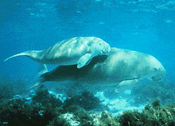
One of the more unusual marine mammals in the Persian Gulf is the dugong (Dugong dugon). Also called “sea cows”, for their grazing habits and mild manner resembling livestock, dugongs have a life expectancy similar to that of humans and they can grow up to 3 metres (9.8 feet) in length. These gentle mammals feed on sea grass and are closer relatives to certain land mammals than are dolphins and whales. Their simple grass diet is negatively affected by new developments along the Persian Gulf coastline, particularly the construction of artificial islands by Arab states and pollution from oil spills caused during the “Persian Gulf war” and various other natural and artificial causes. Uncontrolled hunting has also had a negative impact on the survival of dugongs. After Australian waters, which are estimated to contain some 80,000 dugong inhabitants, the waters of Qatar, Bahrain, UAE, and Saudi Arabia make the Persian Gulf the second most important habitat for the species, hosting some 7,500 remaining dugongs. However, the current number of dugongs is dwindling and it is not clear how many are currently alive or what their reproductive trend is. Unfortunately, ambitious and uncalculated construction schemes, political unrest, ever-present international conflict, the most lucrative world supply of oil, and the lack of cooperation between Arab states and Iran, have had a negative impact on the survival of many marine species, including dugongs.
Birds
The Persian Gulf is also home to many migratory and local birds. There is great variation in colour, size, and type of the bird species that call the Persian gulf home. Concerns regarding the endangerment of the kalbaensis subspecies of the collared kingfishers were raised by conservationists over real estate development by the United Arab Emirates and Oman. Estimates from 2006 showed that only three viable nesting sites were available for this ancient bird, one located 80 miles (129 km) from Dubai, and two smaller sites in Oman. Such real estate expansion could prove devastating to this subspecies. A UN plan to protect the mangroves as a biological reserve was ignored by the emirate of Sharjah, which allowed the dredging of a channel that bisects the wetland and the construction of an adjacent concrete walkway. Environmental watchdogs in Arabia are few, and those who advocate the wildlife are often silenced or ignored by developers of real estate, many of whom have governmental connections.
Real estate development in the Persian Gulf by the United Arab Emirates and Oman also raised concerns that habitats of species such as the hawksbill turtle, greater flamingo, and booted warbler may be destroyed.The dolphins that frequent the Persian gulf in northern waters around Iran are also at risk. Recent statistics and observations show that dolphins are at danger of entrapment in purse seine fishing nets and exposure to chemical pollutants; perhaps the most alarming sign is the “mass suicides” committed by dolphins off Iran’s Hormozgan province, which are not well understood, but are suspected to be linked with a deteriorating marine environment from water pollution from oil, sewage, and industrial run offs.
Fish and reefs
The Persian Gulf is home to over 700 species of fish, most of which are native. Of these 700 species, more than 80% are reef associated.These reefs are primarily rocky, but there are also a few coral reefs. Compared to the Red Sea, the coral reefs in the Persian Gulf are relatively few and far between.This is primarily connected to the influx of major rivers, especially the Shatt al-Arab (Euphrates and Tigris), which carry large amounts of sediment (most reef-building corals require strong light) and causes relatively large variations in temperature and salinity (corals in general are poorly suited to large variations).[84][85][86] Nevertheless, coral reefs have been found along sections of coast of all countries in the Persian gulf. Corals are vital ecosystems that support multitude of marine species, and whose health directly reflects the health of the Persian gulf. Recent years have seen a drastic decline in the coral population in the Persian gulf, partially owing to global warming but mostly to irresponsible dumping by Arab states like the UAE and Bahrain. Construction garbage such as tires, cement, and chemical by products have found their way to the Persian Gulf in recent years. Aside from direct damage to the coral, the construction waste creates “traps” for marine life in which they are trapped and die. The result has been a dwindling population of the coral, and as a result a decrease in number of species that rely on the corals for their survival.
Flora
A great example of this symbiosis is the mangroves in the Persian Gulf, which require tidal flow and a combination of fresh and saltwater for growth and act as nurseries for many crabs, small fish, and insects; these fish and insects are the source of food for many of the marine birds that feed on them. Mangroves are a diverse group of shrubs and trees belonging to the genus Avicennia or Rhizophora that flourish in the saltwater shallows of the Persian Gulf and are the most important habitats for small crustaceans that dwell in them. They are as crucial an indicator of biological health on the surface of the water as the corals are to the biological health of the Persian gulf in deeper waters. Mangroves’ ability to survive the salt water through intricate molecular mechanisms, their unique reproductive cycle, and their ability to grow in the most oxygen-deprived waters have allowed them extensive growth in hostile areas of the Persian Gulf. However, with the advent of artificial island development, most of their habitat is destroyed or occupied by man-made structures. This has damaged the crustaceans that rely on the mangrove and in turn on the species that feed on them.
-
Dugong mother and her offspring in shallow water
-
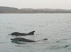
Indo-Pacific bottlenose dolphins off the southern shore of Iran, around Hengam Island
-

Spinner dolphins leaping in the Persian gulf
-

Critically endangered Arabian humpback whales (being the most isolated, and the only resident population in the world) off Dhofar, Oman
-
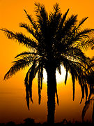
Palm and sunset on Minoo Island
Oil and gas
The Persian Gulf and its coastal areas are the world’s largest single source of petroleum, and related industries dominate the region. Safaniya Oil Field, the world’s largest offshore oilfield, is located in the Persian Gulf. Large gas finds have also been made, with Qatar and Iran sharing a giant field across the territorial median line (North Field in the Qatari sector; South Pars Field in the Iranian sector). Qatar has built up a substantial liquefied natural gas (LNG) and petrochemical industry using this gas.
In 2002, the Persian Gulf nations of Bahrain, Iran, Iraq, Kuwait, Qatar, Saudi Arabia, and the UAE produced about 25% of the world’s oil, held nearly two-thirds of the world’s crude oil reserves, and about 35% of the world’s natural gas reserves. The oil-rich countries (excluding Iraq) with a coastline on the Persian Gulf are referred to as the Persian Gulf States. Iraq’s egress to the Persian gulf is narrow and easily blockaded, consisting of the marshy river delta of the Shatt al-Arab, which carries the waters of the Euphrates and the Tigris rivers, where Iran holds the east bank.
–
FAQ (English + فارسی)
1. Why is the Persian Gulf called “Persian” and not “Arabian”?
English: The name “Persian Gulf” dates back to 550 BC with the Achaemenid Empire. Greek historians like Nearchus (300 BC) called it “Persikon Kaitas.” Inscriptions from Darius the Great also refer to it as the “Pars Sea.” The name has been recognized by the United Nations and the International Hydrographic Organization for over 2,500 years.
چرا نام خلیج فارس است نه خلیج عرب؟
نام «خلیج فارس» به ۵۵۰ سال قبل از میلاد و امپراتوری هخامنشی بازمیگردد. مورخان یونانی مانند نئارکوس (۳۰۰ قبل از میلاد) آن را «پرسیکون کایتاس» نامیدند. کتیبههای داریوش بزرگ نیز از آن به عنوان «دریای پارس» یاد کردهاند. این نام بیش از ۲۵۰۰ سال است که توسط سازمان ملل و سازمان بینالمللی آبنگاری تأیید شده است.
2. Which countries border the Persian Gulf?
English: Eight countries border the Persian Gulf: Iran, Iraq, Kuwait, Saudi Arabia, Qatar, Bahrain, the United Arab Emirates (UAE), and Oman (specifically the Musandam exclave). Iran has the longest coastline (1,536 km), while Iraq has the shortest (58 km).
کدام کشورها هممرز با خلیج فارس هستند؟
هشت کشور با خلیج فارس هممرز هستند: ایران، عراق، کویت، عربستان سعودی، قطر، بحرین، امارات متحده عربی و عمان (منطقه مَسندم). ایران با ۱٬۵۳۶ کیلومتر طولانیترین خط ساحلی و عراق با ۵۸ کیلومتر کوتاهترین خط ساحلی را دارد.
3. How deep is the Persian Gulf on average?
English: The Persian Gulf is relatively shallow. Its average depth is only 50 meters (164 feet), and its maximum depth is 90 meters (300 feet). This shallowness makes it highly sensitive to temperature changes, evaporation, and pollution.
عمق متوسط خلیج فارس چقدر است؟
خلیج فارس نسبتاً کمعمق است. میانگین عمق آن تنها ۵۰ متر و حداکثر عمق آن ۹۰ متر است. این کمعمقی باعث میشود نسبت به تغییرات دما، تبخیر و آلودگی بسیار حساس باشد.
4. What is the Strait of Hormuz and why is it important?
English: The Strait of Hormuz is a narrow passage (only 55 km wide) connecting the Persian Gulf to the Gulf of Oman and the Indian Ocean. It is the world’s most important oil transit chokepoint. Approximately 20-30% of the world’s seaborne oil passes through it daily.
تنگه هرمز چیست و چرا مهم است؟
تنگه هرمز یک گذرگاه باریک (تنها ۵۵ کیلومتر عرض) است که خلیج فارس را به دریای عمان و اقیانوس هند متصل میکند. این تنگه مهمترین نقطه ترانزیت نفت در جهان است. روزانه حدود ۲۰ تا ۳۰ درصد نفت دریایی جهان از آن عبور میکند.
5. What kind of wildlife lives in the Persian Gulf?
English: Despite industrial activity, the Persian Gulf hosts unique wildlife, including the endangered dugong (“sea cow”), Indo-Pacific humpback dolphins, hawksbill turtles, and over 700 species of fish. It also has extensive mangrove forests (Avicennia and Rhizophora) that act as nurseries for marine life.
چه نوع حیات وحشی در خلیج فارس زندگی میکند؟
علیرغم فعالیتهای صنعتی، خلیج فارس میزبان حیات وحش منحصربهفردی از جمله دوگونگ (گاو دریایی) در خطر انقراض، دلفینهای کوهاندار، لاکپشتهای پوزهعقابی و بیش از ۷۰۰ گونه ماهی است. همچنین جنگلهای حرا (مانگرو) گستردهای دارد که به عنوان مهدکودک برای جانوران دریایی عمل میکنند.
6. How much oil is produced in the Persian Gulf region?
English: The Persian Gulf nations produce approximately 25% of the world’s oil and hold nearly two-thirds (66%) of global crude oil reserves. The world’s largest offshore oil field, Safaniya (Saudi Arabia), is located here, as well as the world’s largest natural gas field (North Field/South Pars), shared by Qatar and Iran.
چقدر نفت در منطقه خلیج فارس تولید میشود؟
کشورهای حاشیه خلیج فارس تقریباً ۲۵٪ نفت جهان را تولید میکنند و نزدیک به دو سوم (۶۶٪) ذخایر نفت خام جهان را در اختیار دارند. بزرگترین میدان نفتی فراساحلی جهان (صفانیه در عربستان) و بزرگترین میدان گازی جهان (نورث/پارس جنوبی) در این منطقه قرار دارند.
7. Is the Persian Gulf safe for swimming or tourism?
English: Many parts of the Persian Gulf are safe and popular for tourism, especially in Dubai (UAE), Doha (Qatar), and along the Iranian coast (Kish, Qeshm). However, water temperatures are very high in summer (over 35°C), and salinity is extreme. Swimmers should avoid areas near industrial ports and oil terminals.
آیا شنا و گردشگری در خلیج فارس ایمن است؟
بسیاری از نقاط خلیج فارس برای گردشگری ایمن و محبوب هستند، به ویژه در دبی (امارات)، دوحه (قطر) و سواحل ایران (کیش، قشم). اما دمای آب در تابستان بسیار بالا (بیش از ۳۵ درجه) و شوری آب بسیار زیاد است. شناگران باید از مناطق نزدیک بنادر صنعتی و پایانههای نفتی دوری کنند.
8. What is the main environmental threat to the Persian Gulf?
English: The main threats are oil spills, industrial pollution, and coastal construction (artificial islands). The Persian Gulf receives very little freshwater inflow, and its shallow, warm waters cannot dilute pollutants quickly. Desalination plants also discharge hot, salty brine, damaging coral reefs and marine life.
اصلیترین تهدید زیستمحیطی خلیج فارس چیست؟
تهدیدات اصلی شامل نشت نفت، آلودگی صنعتی و ساختوسازهای ساحلی (جزایر مصنوعی) است. خلیج فارس ورودی آب شیرین بسیار کمی دارد و آبهای گرم و کمعمق آن نمیتوانند آلایندهها را سریعاً رقیق کنند. همچنین آبشیرینکنها آب شور و گرمِ پساب تخلیه میکنند که به صخرههای مرجانی و حیات دریایی آسیب میزند.
Thanks for sharing. I read many of your blog posts, cool, your blog is very good.
I may need your help. I tried many ways but couldn’t solve it, but after reading your article, I think you have a way to help me. I’m looking forward for your reply. Thanks.
Your point of view caught my eye and was very interesting. Thanks. I have a question for you.
Thanks
Your article helped me a lot, is there any more related content? Thanks!
Your point of view caught my eye and was very interesting. Thanks. I have a question for you.
Sự phát triển của công nghệ sẽ đưa thế giới tiến gần hơn tới kỷ nguyên số toàn diện — nơi trí tuệ nhân tạo và cảm xúc con người song hành.