

By S. Mahya Hoseini, and Mohsen Soltanpour
A 2D hydrodynamic model is employed to study the characteristics of tidal wave propagation in the Persian Gulf (PG). The study indicates that tidal waves propagate from the Arabian Sea and the Gulf of Oman into the PG through the Strait of Hormuz. The numerical model is first validated using the measured water levels and current speeds around the PG and the 10 principal tidal constituents of Admiralty tide tables. Considering the intermediate width of the PG, in comparison to Rossby deformation radius, the tidal wave propagates like a Kelvin wave on the boundaries. Whereas the continental shelf oscillation
resonance of the basin is close to the period of diurnal constituents, the results show that the tide is mixed mainly semidiurnal.
A series of numerical tests is also developed to study the various effects of geometry and bathymetry of the PG, Coriolis force, and bed friction on tidal wave deformation. Numerical tests reveal that the Coriolis force, combined with the geometry of the 15 gulf, results in generation of different amphidromic systems of diurnal and semidiurnal constituents. The configuration of the bathymetry of the PG, with a shallow zone at the closed end of the basin that extends along its longitudinal axis in the southern half (asymmetrical cross section), results in the deformations of incoming and returning tidal Kelvin waves and consequently
the shifts of amphidromic points (APs). The bed friction also results in the movements of the APs from the centerline to the south border of the gulf.
The shallow semi-enclosed basin of the PG locates in the south of Iran between latitudes 24°-30°N and longitudes 48 °-56 °E (Fig. 1). The PG is connected to the Arabian Sea through the Gulf of Oman by the narrow Strait of Hormuz. Its average depth is about 36 m with the maximum width and length of about 338 km and 1000 km, respectively. The tide in the PG is very 85 complicated, and the dominant pattern, i.e., primarily semidiurnal or diurnal, varies from one region to another (Reynolds, 1993).
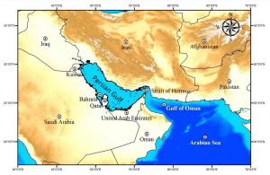
Figure 1: Geography of the Persian Gulf (NOAA 2006).
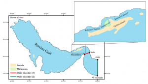
The PG’s natural period of waves is calculated as 22.6 and 21.7 hours based on the Japanese and Chrystal methods, respectively (Defant, 1961). The field measurements are mostly selected from the monitoring and modeling studies in the northern coastline of the PG (PMO, 2015). Tide Gauges (TGs) and AWACs (Acoustic Wave and Current), which are Nortek ADCPs (Acoustic Doppler Current Profiler), were employed in these studies. Taking the advantage of the simple echo sounder principle, a vertically 95 oriented transducer in the center of the AWAC was used to directly measure the distance to the sea surface.
Summary and conclusion
A 2D hydrodynamic model with a relatively high grid resolution, forced by thirteen tidal constituents at its open boundary, was set up to study the tidal wave propagation in the PG. Comparisons of the simulated water levels and tidal currents with measured data at the stations around the PG showed good model performance. The derived constituents from the model results were comparable with the observations of the UK Hydrographic Office (Admiralty) and shallow water constituents were similar to the extracted constituents out of measurements. The co-tidal and co-range charts of four principal tidal constituents
420 were also comparable with the corresponding Admiralty charts.
The results revealed that dominant tide in the PG is mixed mainly semidiurnal with the maximum tidal amplitude of about 2 m in the Khuran Channel and Khowre-Musa .
Considering the data of all northern stations, the largest contributions are semidiurnal, followed by diurnal, long-term, and shallow-water constituents, respectively. Series of numerical tests were carried out to study the effects of the governing factors, i.e., geometry and bathymetry, Coriolis force, and bed roughness on tidal wave propagation in the PG. It was found that the Coriolis force, combined with constraint of the geometry, result in the
rotation of Kelvin waves about the nodal point (AP) and developing the amphidromic system. The second test showed that a transverse step in bathymetry leads to different wavelengths of the incoming and reflected Kelvin waves, resulting in the increased amplitudes in shallow areas, which leads to the shift of diurnal APs toward the deeper part of the PG. The third numerical test demonstrated that bottom friction in a gulf results in the exponential decay of the incoming and reflected Kelvin 430 waves, moving the AP from the centerline.
Read more here: https://doi.org/10.5194/os-2021-98