

 Explore the importance of ship navigation charts in maritime operations. Learn their history, regulations, challenges, and the future of paper vs digital charts.
For centuries, seafarers have relied on charts as their window to the oceans. Before satellites and digital systems, the only way to safely cross the seas was to carefully trace a course on a chart, measure distances, and use bearings from compasses and celestial bodies. Today, even as ships sail with ECDIS (Electronic Chart Display and Information System) and advanced satellite navigation, navigation charts remain legally required under the International Maritime Organization (IMO) and SOLAS conventions.
But why are charts still so important when GPS exists? The answer lies in safety, redundancy, and accountability. Ship navigation charts — whether paper or digital — are the backbone of global maritime trade, guiding the 50,000+ merchant ships that transport around 80–90% of world trade by volume (UNCTAD, 2023).
This article explores the history, function, regulation, challenges, and future of ship navigation charts, combining real-world cases, modern data, and maritime training insights.
–
Why Navigation Charts Matter in Maritime Operations
Navigation charts are more than maps. They are legal documents, safety tools, and decision-making guides. Every chart is produced by a national hydrographic office (e.g., UKHO, NOAA, or China MSA) and carries authority.
-
Safety of Navigation
Charts show depths, shoals, shipping lanes, restricted zones, and navigational aids like lighthouses and buoys. Without them, ships risk groundings, as seen in the Ever Given incident in the Suez Canal (2021), which disrupted global trade. -
Legal Compliance
According to SOLAS Chapter V, Regulation 27, all ships must carry up-to-date charts and publications. Failure to comply may result in detention by Port State Control (Paris MoU, Tokyo MoU). -
Training and Competence
Under the STCW Convention, cadets must demonstrate chartwork skills. Even officers sailing with full ECDIS setups are trained to use paper charts in case of digital failure. -
Evidence in Investigations
A properly filled paper chart can be used in maritime accident investigations by bodies like the Marine Accident Investigation Branch (MAIB) or EMSA to reconstruct a voyage.
–
Types of Ship Navigation Charts
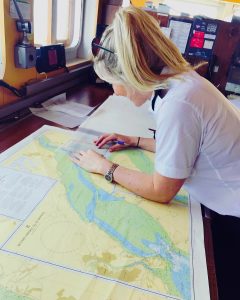
Paper Navigation Charts
Paper charts are the traditional, physical foundation of maritime navigation. Printed on large sheets by national hydrographic offices, they provide a detailed and static visual representation of water depths, hazards, coastlines, and aids to navigation. Their use is entirely manual; mariners plot courses and positions using tools like parallel rulers, dividers, and pencils. Their principal advantage is their complete reliability as they require no power or external systems, making them the ultimate backup. Their main disadvantages are the labor-intensive process of manual plotting and the cumbersome, error-prone method of updating them via weekly Notices to Mariners.
Electronic Navigation Charts (ENCs)
ENCs are intelligent, data-rich vector charts approved for primary use in Electronic Chart Display and Information Systems (ECDIS). Unlike a simple image, every feature on an ENC is an object with attributes that can be queried. They are highly interactive and form the core of modern integrated navigation by automatically overlaying real-time data from GPS, radar, and AIS. Their key advantages are enhanced situational awareness, automated safety alarms for hazards, and efficient digital updates. Their primary disadvantage is system dependency, creating a risk of over-reliance and potential failure if power or signals are lost.
Raster Navigation Charts (RNCs)
RNCs are digital facsimiles of paper charts, created by scanning the paper original into a raster image format. They are used within a Raster Chart Display System (RCDS), often as a mode within ECDIS. Their main advantage is providing a familiar, digitally accurate copy of the official paper chart, serving as an excellent secondary digital backup. Their significant limitations are a lack of intelligent features; they cannot be interrogated for object data, lack automated safety alarms, and must be updated manually. They are legally considered a secondary system to ENCs.
–
Key Developments and Innovations
Digital Transition (ECDIS)
Since 2018, all SOLAS vessels above 10,000 GT must carry ECDIS. This was a milestone in the IMO’s push for digitalization. ECDIS integrates ENCs with position data, alarms for shallow water, and route planning tools.
e-Navigation Strategy
The IMO, in cooperation with IALA (International Association of Marine Aids to Navigation and Lighthouse Authorities), promotes e-navigation: a harmonized digital environment where charts, sensors, and communication systems converge.
Online Updating Systems
The UK Hydrographic Office (UKHO) and NOAA now provide weekly digital updates to charts, reducing human error in manual corrections — a common weak point with paper charts.
Autonomous Ships and Smart Ports
Future autonomous vessels will depend on fully digital charts integrated with AI and real-time hydrographic data (Lloyd’s Register, 2023). Yet, regulators still insist on redundancy.
–
Challenges and Practical Solutions
Maintaining Chart Updates
A significant challenge is the maintenance of chart updates, particularly for paper charts which require manual weekly corrections via “Notices to Mariners.” Any missed updates can render a chart legally invalid and dangerously outdated. As a practical solution, many shipping companies now outsource this critical task to certified correction services to ensure accuracy. For vessels using ECDIS, this process is resolved through seamless digital updates that are automated and applied directly to the Electronic Navigation Charts.
Human Error in Chartwork
The risk of human error in traditional chartwork remains a persistent problem, where simple mistakes like incorrect plotting or selecting the wrong chart scale can lead to serious accidents. To mitigate this, the industry is addressing the issue through enhanced STCW training standards and the widespread use of simulator-based practice at maritime academies, such as the Massachusetts Maritime Academy, to build muscle memory and reinforce proper procedures.
Cybersecurity in ENCs
With the reliance on digital systems, a modern challenge involves cybersecurity for Electronic Navigation Charts. ENCs and the ECDIS that run them are vulnerable to threats like hacking and GPS spoofing, which could compromise navigation safety. In response, the International Maritime Organization (IMO) has mandated that cybersecurity risk management be incorporated into all Safety Management Systems under Resolution MSC.428(98), which came into effect in 2021.
The Debate Over Paper vs Digital
A fundamental industry debate continues between paper and digital navigation. This was highlighted in 2022 when the UK Hydrographic Office (UKHO) announced its intention to withdraw from producing paper charts by 2030, a plan that was later extended after significant industry pushback. A core argument from many mariners is that paper charts provide a level of resilience and independence from technical failure that digital systems cannot yet match.
Case Studies and Real-World Applications
Case 1: The Costa Concordia Disaster (2012)
Investigations revealed failures in voyage planning and inadequate use of charts. This reinforced IMO’s push for stricter ECDIS adoption and proper passage planning.
Case 2: GPS Jamming in the Black Sea (2017)
Over 20 ships reported false GPS positions. Those relying solely on ECDIS faced serious risk, while vessels cross-checking with paper charts and compass bearings avoided incidents.
Case 3: Training Voyages on Tall Ships
Sail-training vessels like STS Pogoria (Poland) or USCGC Eagle (USA) still train cadets with sextants, compasses, and paper charts. This proves traditional navigation is alive, not just historical.
–
Future Outlook and Trends
The future of navigation charts sits at the crossroads of digital transformation and traditional seamanship.
-
Full Digitalization by 2030?
Many hydrographic offices aim to phase out paper charts. Yet, resistance from seafarers and safety experts means a hybrid system may last longer. -
AI and Predictive Navigation
Companies like Wärtsilä are experimenting with AI-assisted route optimization using ENC data and real-time oceanographic models. -
Integration with Smart Ports
As ports digitize (e.g., Singapore, Rotterdam), ship charts will integrate with port traffic management, offering predictive ETA and berth allocation. -
Environmental Considerations
Updated charts will include Marine Protected Areas (MPAs) and emission control zones, aligning with IMO’s GHG reduction strategy.
–
Frequently Asked Questions
1. Why do ships still need paper charts if they have ECDIS?
Because IMO requires redundancy. Paper ensures safety if electronic systems fail.
2. Who produces navigation charts?
National hydrographic offices, coordinated by the International Hydrographic Organization (IHO).
3. Are electronic charts safer than paper charts?
Not inherently. They reduce human error but introduce cybersecurity risks. Best practice is to use both.
4. How often must charts be updated?
Weekly, through Notices to Mariners or automatic ENC updates.
5. Can small vessels use ENCs?
Yes, but non-SOLAS vessels often rely on paper or commercial apps (Navionics, C-MAP).
6. What is the legal status of a navigation chart?
It is an official document. Failure to carry or update charts can lead to detention under Port State Control.
–
Conclusion
Ship navigation charts are the silent guardians of the seas. From the parchment charts of Magellan’s voyages to today’s interactive ENCs, they remain central to maritime safety and trade. Despite the rise of digital technology, the compass and paper chart continue to represent a line of defense against overreliance on electronics.
The future may see AI-driven smart charts, but the principle will remain the same: safe navigation depends on accurate, updated charts and competent mariners. For maritime students and professionals, mastering both paper and electronic chart navigation is not just tradition — it’s a necessity that keeps global trade afloat.
References
-
International Maritime Organization (IMO). SOLAS Chapter V: Safety of Navigation
-
International Hydrographic Organization (IHO). Standards and Charting
-
UNCTAD (2023). Review of Maritime Transport 2023. UNCTAD Report
-
UK Hydrographic Office (2023). Future of Paper Charts
-
Lloyd’s Register (2023). The Future of Navigation and Cyber Risk.
-
Marine Accident Investigation Branch (MAIB). Investigation Reports
-
Bowditch, N. The American Practical Navigator. NOAA.
-
EMSA (2023). Annual Overview of Marine Casualties and Incidents.
-
Massachusetts Maritime Academy. Navigation Training Programs
Thx