

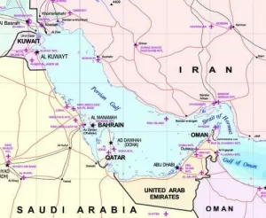
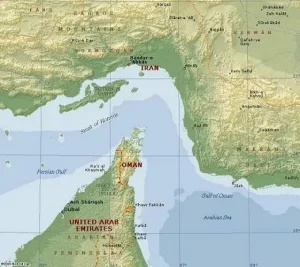
The Persian Gulf is the body of water bordering Iran, Iraq, Kuwait, Saudi Arabia, Bahrain, Qatar, United Arab Emirates, and Oman. The Persian Gulf covers area of approximately 87,000 square miles, with a maximum depth of about 330 feet and an average depth of about 115 feet.The only maritime outlet from the Persian Gulf into the Gulf of Oman, the Indian Ocean, and the rest of the world is through a narrow chokepoint, the Strait of Hormuz.
The Persian Gulf region produces nearly one third of the world’s oil and holds over half of the world’s crude oil reserves as well as a significant portion of the world’s natural gas reserves. Oil and natural gas from the Persian Gulf are exported to consumers everywhere, especially to Asia, Western Europe, and the United States.
The Strait of Hormuz is a narrow waterway that connects the Persian Gulf and the Gulf of Oman – the only passage from the oil-rich gulf to the Indian Ocean for maritime traffic. The Strait is among the world’s most important oil chokepoints. Oil tankers carry approximately 17 million barrels of oil each day through the Strait, or 20 to 30 percent of the world’s total consumption. Other outlets for oil exports from the region, such as pipelines, are limited. As such, approximately 88 percent of all oil leaving the Persian Gulf goes via the Strait of Hormuz.
The Strait itself is about 30 miles wide at the narrowest point. In order to regulate the movement of large ships in these constrained waters, the UN’s International Maritime Organization has recognized a Traffic Separation Scheme (TSS). The TSS consists of two, two-mile wide shipping lanes: one for incoming traffic and one for outgoing traffic. These two shipping lanes are separated by a two-mile buffer zone. Overall, the narrow confines of the TSS offer oil tankers and other large commercial (and military) ships very little room for maneuver and very little capability to avoid obstructions within the TSS.
However, much more of the Strait than the TSS is deep enough for even the very largest of oil tankers. As a result, for a barrier to ship traffic to disrupt the flow of oil, it would have to cross the width of the Strait not just the narrow band of the TSS.
The Strait of Hormuz is geo-strategically important to the United States, as the health of the world economy depends on the flow of oil. Many pundits and analysts, often cited by politicians and the media, fear that an Iranian attempt to close the Strait would threaten the global economy. Their implicit assumption is that Iran could stop the transit of a substantial amount of oil through the Strait for a prolonged period of time. However, as the information on this website illustrates, creating a major disruption in the Strait would be extremely difficult due to various economic, political and military forces present in the region today.
Area Unsafe for Tankers
Caption: Map that shows bathymetry of the Strait (Note: “Unsafe” for tankers indicates that the depth of the water in that area is less than 25 meters – a fully laden supertanker will have draft, or the height of the vessel below the ocean surface, of 20-25 meters). The graphic to the right shows a high-level view of the different depths of the Strait. Note that, if necessary, fully laden VLCCs could safely navigate through most of the Strait – not just the TSS.
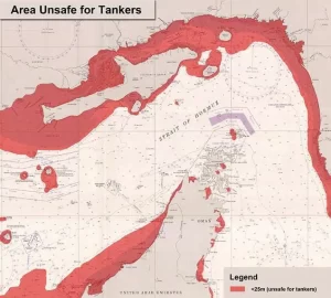
Source: Original map taken from the University of Texas, PCL Collection
–
Frequently Asked Questions
1. Why is the Strait of Hormuz considered the world’s most dangerous oil chokepoint?
Because nearly all of the Persian Gulf’s oil must pass through it – and it’s incredibly narrow.
-
Only 30 miles wide at its narrowest point
-
Two 2‑mile shipping lanes (one inbound, one outbound) separated by a 2‑mile buffer
-
Very little room to maneuver – huge oil tankers (VLCCs) need 20–25 meters of depth, and the safe lanes are tight
If something blocks those lanes – a shipwreck, a mine, or military action – global oil supplies could be disrupted for days or weeks.
2. How much oil actually flows through the Strait of Hormuz every day?
Approximately 17 million barrels per day – that’s 20–30% of the world’s total oil consumption.
Even more striking:
-
The Persian Gulf region produces nearly one‑third of the world’s oil
-
It holds over half of global crude oil reserves and huge natural gas reserves
-
88% of all oil leaving the Persian Gulf goes via the Strait of Hormuz
Pipelines exist, but their capacity is limited – so the Strait is essentially irreplaceable.
3. Could Iran actually close the Strait of Hormuz?
Many pundits and politicians fear that Iran could shut it down, threatening the global economy. But the article argues: creating a major, prolonged disruption is extremely difficult.
Why?
-
Depth matters – most of the Strait is deep enough for supertankers (not just the narrow TSS lanes)
-
Military and political forces – the US and other navies are present and would likely intervene
-
Economic self‑harm – Iran also relies on the Gulf for its own oil exports
The implicit assumption that Iran could stop a substantial amount of oil for a long time is probably wrong – but even a short disruption would spike prices.
4. What is the Traffic Separation Scheme (TSS) and why does it matter?
The TSS is the UN’s regulated shipping lane system through the Strait of Hormuz.
-
Two 2‑mile wide lanes – one for incoming tankers, one for outgoing
-
A 2‑mile buffer zone between them
Inside the TSS, ships have very little room to avoid obstacles – a single grounded tanker could block one lane. But here’s the key: most of the Strait is deeper than the TSS. A blockade would have to span the entire 30‑mile width, not just the narrow TSS, to truly stop all traffic.
5. What happens to gas prices if the Strait is blocked – even temporarily?
Even a short disruption would trigger:
-
Supply delays – tankers can’t reach refineries in Asia, Europe, and the US
-
Higher shipping costs – rerouting around Africa adds weeks and millions of dollars
-
World energy price spikes – because 17 million barrels/day don’t just vanish from the market
The article notes that the Strait is geo‑strategically important to the US because the health of the world economy depends on that oil flow.
6. Which countries are most dependent on the Strait of Hormuz?
Asia, Western Europe, and the United States are the biggest consumers of Persian Gulf oil.
-
China, India, Japan, South Korea – massive importers via the Strait
-
US – still imports oil from Gulf countries, though less than in past decades
Without the Strait, these countries would face immediate energy shortages and would have to tap strategic reserves or pay emergency prices.
7. Are there any alternative routes for Persian Gulf oil?
Yes – but very limited.
-
Saudi Arabia has a pipeline to the Red Sea
-
UAE has a pipeline to Fujairah Port, bypassing Hormuz
However, the article states clearly: “Other outlets for oil exports from the region, such as pipelines, are limited.” The vast majority – 88% – still must go through the Strait of Hormuz.
8. How deep is the Strait of Hormuz – can supertankers go outside the marked lanes?
The average depth of the Persian Gulf is only about 115 feet, but the Strait itself has deeper channels.
-
Fully laden VLCCs (Very Large Crude Carriers) have a draft of 20–25 meters (65–82 feet)
-
The article’s map shows that most of the Strait is deeper than 25 meters – marked as “unsafe for tankers” only in shallow patches
That means: a blockade would have to cover the entire 30‑mile width of the Strait, not just the narrow TSS lanes, to stop all traffic. That’s much harder to achieve.
9. What’s the single biggest myth about the Strait of Hormuz?
The myth: “Iran could easily close the Strait and cripple the global economy.”
The reality, based on this article:
-
Physical difficulty – the Strait is wide enough and deep enough that a full closure would require blocking a massive area
-
Military countermeasures – the US Navy and allies would almost certainly clear any blockade
-
Economic cost to Iran – they also need the Strait for their own exports
That doesn’t mean the Strait is safe – just that a prolonged, total shutdown is extremely unlikely. But even a short disruption would cause panic and price spikes.