
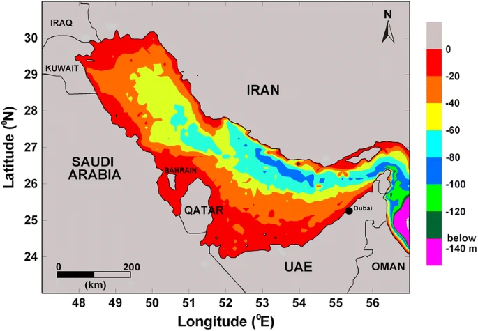
The Persian Gulf is a marginal and semi-enclosed sea situated in the subtropical region of the Middle East between latitudes 24o and 30o N and longitudes 48o and 57o E . The Persian Gulf constitutes part of the Arabian Sea Ecoregion, and represents a realm of the tropical Indo-Pacific Ocean It is a shallow sedimentary basin with an average depth of 35 m and a total area of approximately 240,000 km2.
Due to the high-latitude geographical position, the relative shallowness and the high evaporation rates, the Persian Gulf is characterized by extreme environmental conditions. Sea temperatures are markedly fluctuated between winter and summer seasons (15 – 36°C). Salinity can exceed 43 psu and may reach 70-80 psu in tidal pools and lagoons. Therefore, marine organisms in the Persian Gulf are living close to the limits of their environmental tolerance.
Despite these harsh environmental conditions, the Persian Gulf supports a range of coastal and marine ecosystems such as mangrove swamps, seagrass beds, coral reefs, and mud and sand flats. These ecosystems contribute to the maintenance of genetic and biological diversity in the marine environment and provide valuable ecological and economic functions as they form feeding and nursery grounds for a variety of commercially important marine organisms.
However, these ecosystems are under ever-increasing pressure from anthropogenic activities that are associated with the rapid economic, social and industrial developments in the Persian Gulf countries. The Persian Gulf is considered among the highest anthropogenically impacted regions in the world . The coasts of the Persian Gulf are witnessing rapid industrialization and urbanization that contribute to the degradation of naturally stressed marine ecosystems. Coastal and marine environments are affected by intensive dredging and reclamation activities, and several sources of pollution, including industrial waste, brine waste waters, ports and refiners, oil spills, and domestic sewage. These threats warrant the designation of the Arabian Sea Ecoregion, including the Persian Gulf as ‘critically endangered by the International Union for the Conservation of Nature (IUCN) and the World Wildlife Fund (WWF) (http://wwf.panda.org).
Due to its unique environmental setting, the Persian Gulf is increasingly receiving international scientific interest in studying the effects of environmental extremes on marine organisms and to investigate the potential impacts of future climate change on the ecological integrity of marine ecosystems.
The Growing Need for Sustainable Ecological Management of Marine Communities of the Persian Gulf
The Persian Gulf is a semi-enclosed marginal sea, connected to the Gulf of Oman through the 56 km wide Strait of Hormuz (Fig. 1). It is a major shipping route for ports in the Middle East and South Asia, and for the global oil transport industry, and its eight bordering countries include several that are experiencing a rapid and very extensive coastal development, chiefly for up-scale residential communities. The Persian Gulf’s geography, climate, and pattern of use put it at risk for various types of environmental degradation, and the current capacity for environmental management is inadequate. This article builds upon several recent reviews of the state of the Persian Gulf (, and makes recommendations for suitable steps to improve environmental management in the face of growing anthropogenic pressures.

The Persian Gulf, 239,000 km2 in area, is a semi-enclosed marginal sea, has an average water depth of 36 m, a maximum internal depth of 94 m, a shallow broad southern margin along the coast of U.A.E., and a relatively narrow and deep north-eastern margin along the coast of Iran
Part 1: Physical and Biological Description
The marine environment of the Persian Gulf is characterized by extreme environmental conditions, which are attributed to its location and bathymetry. The Gulf experiences high rates of evaporation, which exceed the combined levels of rainfall and river discharge. As a result, an inverse estuarine and counterclockwise circulation pattern prevails in the Gulf. The northern part of the Strait of Hormuz serves as the entry point for surface water that penetrates deep into the Gulf along the Iranian coast. This wedge of less saline water increases in salinity and exits at depth through the Strait of Hormuz. During summer, the average surface water temperature in the Persian Gulf is 33°C, with the highest recorded temperature being 37.7°C. In contrast, the average winter SST ranges from 22°C near the Strait to 16°C near the head of the Gulf. The lowest recorded SST was 11.5°C. In winter, salinity levels as high as 43 have been observed toward the head of the Gulf.
Physical Environment
nterspersed with occasional outcrops of coral-dominated limestone habitats. Subtidal sediments consist of thin layers of relatively pure carbonate sands or mud over consolidated conglomerates. In areas with weaker currents, sand and shell gravel accumulate, providing habitat for infaunal and epibenthic organisms. Mudflats are the dominant intertidal habitats along the coastline of the western Gulf, where water movements are less turbulent. Due to the discharge of silt from the Tigris and Euphrates Rivers, 57% of the Kuwait coastline is characterized by gently sloping mudflats. These mudflats are often covered by dense, highly productive microbial mats, which form an essential habitat and food source for intertidal macrofauna.
Sabkhas are coastal flats at or just above the level of normal high tide, characterized by unconsolidated carbonate or siliciclastic sediments, diagenetic evaporite minerals, aeolian deposits, and a variable association of sedimentary structures. These areas are typically devoid of vegetation, or sparsely covered with dwarf shrubs and tussock grasses.
True coral reefs do not exist within the Persian Gulf, and corals generally form a veneer on areas of exposed limestone cap-rock. Owing to the friable nature of this substratum and repeated mass mortality of corals due to environmental extremes in the area, corals generally do not build true reef framework. Approximately 60 species of scleractinian coral have been described for the Persian Gulf, representing approximately one tenth of corals known for the Indo-Pacific and 15% of those in the Indian Ocean. The coral communities of the Gulf are depauperate, owing almost certainly to its environmental extremes, and are therefore quite distinct from those in the major biogeographic regions surrounding the Arabian Peninsula.
Ecology and Biogeography
T
The topics discussed in this passage have been previously covered by various authors. The typical coastal communities found in the Indian Ocean are present in the Persian Gulf, but are often represented in low numbers due to isolation and harsh environmental conditions. The naturally occurring mangroves in the Gulf are primarily of the Avicennia marina species and are found in lagoons and on leeward sides of spits, islands, and shoals along the Iranian coast as well as in Saudi Arabia, Bahrain, Oman, Qatar, and the U.A.E. However, they are absent in Iraq and Kuwait. The high salinity in the area leads to stunted growth and poor development of mangrove trees.
The seagrass communities of the Persian Gulf consist of three euryhaline species, Halodule univervis, Halophila ovalis, and Halophila stipulacea, and are prevalent along southern and western shores. These communities are important habitats for fishery species, including nursery habitats for many fish, and commercially important species such as Penaeus semisulcatus and Pinctada radiata. The seagrass beds also support the green turtle, Chelonia mydas, and the world’s second largest population of the endangered dugong, Dugong dugong.
Macroalgal beds are also present, often mixed in with seagrasses, and are vital settlement sites and nurseries for various fishes, shrimp post-larvae, and oyster spat. However, the extreme summer conditions in the area only allow for seasonal presence. Phytoplankton productivity is favored by high nutrient levels, but there is considerable disparity among studies characterizing the plankton communities of the Gulf.
The Gulf is occupied by various marine species such as dolphins, whales, and the Whaleshark Rhyncodon typus. The fish fauna is Indian Ocean derived, but species diversity is lower than that of the Gulf of Oman, and there are few endemic species. Deeper waters in the northern and eastern Gulf have higher species richness than the southern region, and there is significant seasonality in recruitment and adult movement of coastal fish communities.
The crustacea, mollusca, and echinodermata are the best-known invertebrate groups in the Persian Gulf and are important as food species throughout the region. However, these groups are less diverse compared to the Gulf of Oman, and the paucity of research available may exaggerate these trends. Polychaete species diversity and endemicity are higher in the Persian Gulf than in either the Arabian Sea or the Gulf of Oman.
Part 2: Human Impacts on the Persian Gulf Ecosystem
Fisheries and Conservation
Fishing in the Persian Gulf is largely artisanal, with a focus on demersal species in the south and west, and shrimp and pelagic fish in the north. The Gulf has significant fishery resources, estimated at 550,000 tonnes annually by the UN Food and Agriculture Organization, making it the most important renewable natural resource and second only to oil in importance. Despite regulations on fishing effort, many species have been heavily exploited, and fishing effort is already too high for most demersal species. Stock status data is limited and regulations are weak, inconsistently enforced, or inconsistent across jurisdictions.
Around 20 marine protected areas have been designated for conservation protection, covering 12,000 km2 in total. Commercial fishing is typically prohibited in these areas, as are activities such as construction or shore-based development. Similar restrictions apply to oil leases, with some success in policing, although enforcement is generally weak. Effective management of marine protected areas could help to lower rates of exploitation of fishery species and protect other valued species. Improving the enforcement of existing regulations could help Gulf nations to better manage and conserve their marine resources.
Hydrocarbon Pollution
The Persian Gulf region holds the world’s largest hydrocarbon reserve, with over 76 × 109 tonnes of recoverable oil and 32.4 × 10¹² m3 of gas reserves. The area is home to approximately 800 offshore oil and gas platforms and 25 major oil terminals. The Strait of Hormuz sees about 25,000 tankers annually, carrying roughly 60% of all the oil transported by ships worldwide.
Oil exploration, production, and transport, as well as military activities, are the primary sources of pollution in the Persian Gulf. The most significant long-term threat is the chronic contamination of coastal waters, resulting from the constant discharge of oil from harbors, ballast water, terminals, atmospheric fallout, and sewage-plant effluents. During the Gulf War, Iraqi troops intentionally spilled an estimated 10.8 million barrels of oil from abandoned tankers and coastal terminals. This event affected over 700 km of coastline from southern Kuwait to northern Saudi Arabia, but the coastal benthic habitats have since made a remarkable recovery.
The high hydrocarbon content in the Persian Gulf has favored bacterial assemblages capable of mineralizing crude oils, aided by the warm and nutrient-rich waters of the region. Although hydrocarbon pollution levels are persistently high throughout the waters of the Persian Gulf, especially along the Iranian coast, the associated toxic compounds related to combustion of crude oils and metal contamination related to oil spills are not exceptionally high compared to impacted sites in northern Europe and North America.
Wastewater
The Persian Gulf is home to several major manufacturing industries such as fertilizer, chemical, petrochemical, mineral, and plastic production, as well as an expanding agricultural sector due to the availability of capital and demand for fresh produce. Unfortunately, these activities have led to the discharge of various chemicals, including heavy metals, oil and petroleum-based compounds, nutrients, and halogenated organics into the coastal marine sediments via wastewater. Despite high standards for wastewater treatment in the Gulf region, significant amounts of domestic and industrial wastewater still enter the local waters. While most sewage undergoes secondary or tertiary treatment before discharge, large amounts of nutrients and other pollutants also enter the Gulf from inland sources, such as rivers in southern Iran and southeastern Iraq, which are estimated to carry 300,000-500,000 m3 days-1 of wastewater to the Gulf. Agricultural runoff containing organic pollutants also enters through river systems, leading to localized eutrophication and reduced oxygen levels in coastal waters.
Desalination, A Growing and Urbanized Population
The Persian Gulf region is home to major manufacturing industries producing fertilizers, chemicals, petrochemicals, minerals, and plastics. These industries, along with agricultural development, have led to the discharge of a variety of chemicals including heavy metals, oil and petroleum-based compounds, nutrients, and halogenated organics into coastal marine sediments via wastewater.
Despite high standards for wastewater treatment throughout the Gulf region, significant amounts of domestic and industrial wastewater still enter local waters, including large quantities of nutrients and other pollutants from further inland. Agricultural runoff carrying organic pollutants also enters through river systems, causing localized eutrophication and lowered oxygen levels in coastal waters.
Desalination is the principal source of potable water in the region due to the shortage of freshwater resources, supplying from 66% to 90% of the water used. However, waste brine and pre- and post-treatment chemicals from desalination plants may pose a serious threat to the marine environment, with few studies examining the potential effects on Gulf marine fauna.
The countries bordering the Persian Gulf have experienced high rates of economic and population growth, leading to significant changes to large areas of ecologically productive coastal habitats throughout the Gulf. Coastal dredging and development for industrial, commercial, and residential use have altered intertidal flats, mangrove forests, fringing coral reefs, seagrass beds, and sandy embayments. There is a lack of capacity in environmental regulatory agencies to help guide this growth, resulting in negative environmental impacts.
Development in Dubai: Marine Ecosystems damaged by the Nakheel Marine Development Projects
Coastal development projects in the Persian Gulf, particularly in Bahrain, Qatar, and the U.A.E., are expected to have significant and long-lasting impacts on the region’s health. Although major developments are already in place or under construction, little information is available on their short- and long-term environmental effects. The scale of development can be seen in the growth of Dubai, where the government-owned developer Nakheel has constructed a series of large-scale, entirely man-made island-lagoon complexes along the coast since 2002, increasing Dubai’s coastline from about 70 to 1500 km. The effects of these developments on marine communities in Dubai may serve as an indication of what is to come in the region.

This image displays the coastline of Dubai and showcases the offshore developments of Palm Jebel Ali, Palm Jumeirah, and The World (from left to right). The outer crescent of Palm Jumeirah has a diameter of approximately 5 km, and the water depth is around 10 m at the outer limits of Palm Jumeirah and Palm Jebel Ali. The World is slightly deeper. All these developments are a mix of residential, retail, and tourism properties. The image is courtesy of the Image Science & Analysis Laboratory at NASA Johnson Space Center and was captured from the International Space Station (Expedition 18). It is part of the “Astronaut Photography of Earth—Display Record” collection.

The Atlantis Dubai Hotel in final stages of construction. The 1500-roomed hotel, aquarium, and theme park occupies a 45 ha site at the tip of the surrounding crescent directly seaward of the tip of Palm Jumeirah. It is 6 km seaward of the original coastline. Photo: K. Drouillard
In 2006, a collaboration between Nakheel and the United Nations University–Institute for Water, Environment and Health (UNU–INWEH) was established to develop an environmental management program for the marine ecosystems affected by the constructed island-lagoon complexes. As little information was available on the potential impacts on marine ecosystems, an environmental monitoring program was initiated, along with a suite of ecological studies to better understand the marine ecosystems present.
The results of the study demonstrate that the prevailing dredge and fill procedures generate sediment plumes that are both widespread and long-lasting, which is of particular concern as Nakheel plans further construction in Dubai waters. Additionally, the constructed islands permanently modify coastal water movement and sediment transport, with the extent and nature of the modification varying based on island shape and orientation. These modifications have significant long-term effects on the composition of infauna, which is influenced by the sediment type.
While the constructed islands provide new habitats for a variety of species adapted to rocky shores, reefs, or shallow, sandy lagoons, there are substantial and long-term (decadal) effects on the composition of fauna associated with the constructed islands and breakwaters. These effects are due to successional processes, as well as complex seasonal variation resulting from patterns of faunal migration and recruitment. The findings of this study are expected to be useful for evaluating the potential impacts of coastal development throughout the Persian Gulf.

The snapper, Lutjanus ehrenbergii, sea urchins, and oysters living on the Nakheel breakwater at The World. Photo: Nakheel, with permission
The type of material used to construct breakwaters can affect some components of the benthic community, including corals, so that similar construction, but the use of different materials can lead to quite different environmental outcomes; and
Specific design aspects of an island development can introduce significant local, physical, and chemical changes that degrade habitat quality and favor undesirable species, or prevent colonization of the site by desired species of aquatic organism.
The benthic footprint of Palm Jumeirah was found to extend over 800 m beyond the outer crescent breakwater. The sediment composition within 800 m of the breakwater was dominated by silt and finer particles (<63 μm), unlike surface sediments typically found on the inner shelf along the Dubai coastline (≥125 μm). As a result, infaunal communities were dominated by polychaetes <800 m from the crescent, while small crustacea (Amphipoda, Isopoda, etc.) dominated further away. These fine sediments were prone to resuspension under moderate sea conditions, leading to high sedimentation rates on some parts of the rocky breakwaters. No studies have been carried out to determine the impacts of this increased sedimentation on native biota.
The construction of Palm Jebel Ali and other Nakheel constructions in close proximity resulted in the burial or heavy impact of most of the dense coral habitat in Dubai, with coastal development responsible for much of the loss and degradation of coral habitat.
Breakwater orientation had a significant impact on the benthic community that developed due to patterns of sediment deposition associated with differences in water movement and wave exposure. Windward breakwater communities had low levels of sediment deposition and were dominated by coral species, while leeward breakwater communities held higher levels of fine sediment and were dominated by algal turfs and oysters.
The presence of Palm Jumeirah had a substantial effect on the surrounding mid-water communities, with significantly higher abundances of phytoplankton on the east side of Palm Jumeirah than on the west. Plankton community composition differed substantially, with the eastern lee dominated by diatoms, while waters west of the development were dominated by a range of dinoflagellate species.
There was a significant difference in the flushing rates observed between the western and eastern halves of the large annular lagoon, which was not predicted by modeling before construction. Breakwaters <5.5 years old were dominated by algae and oysters, while corals became the dominant member of the benthic community on breakwaters >25 years, with abundances that exceeded those on natural reefs in the area.
Seasonality affects benthic and fish communities substantially, with recruitment of corals highly seasonal, occurring in late spring and early summer. Differences among species in the timing of recruitment may lead to different assemblages developing on breakwaters constructed at different times of the year. Higher densities of reef-associated fish are associated with breakwaters than natural reefs during the warmer summer and autumn seasons.
Cast concrete in various configurations and quarried gabbro, sandstone, and limestone have been used in the construction of breakwaters in the Gulf, and these materials differentially impact recruitment of corals in areas where coral recruitment is high. However, such effects are local, and site-specific differences in larval supply appear to be more important in structuring the wider benthic community on breakwaters in this area.
The construction of the majority of coastal developments in the Gulf has relied solely on locally dredged marine sediments for material, with quantities being enormous. The effects of these extensive dredging activities on local marine communities are not well understood. The construction of Palm Jumeirah also resulted in trench-like borrow pits encircling the project, filled with flocculent, suspended fine sediment that is sometimes anoxic. The organisms present were predominantly species typical of very fine sediments (e.g., Polychaetae).
Harmful Algal Blooms Within the Persian Gulf
Harmful algal blooms (HABs) occur when certain species of phytoplankton produce toxins or reach high levels of biomass that can lead to reduced light penetration or anoxia, which can affect the natural community and food chain. Over the past 30 years, HABs have become more frequent and widespread worldwide.
Enclosed, shallow inland seas that are increasingly affected by human activity are more susceptible to the invasion and establishment of these harmful algal populations. Ballast-laden ships can transfer HAB cells from source areas to new environments, as demonstrated by Hamza (2006) in the Gulf. The new cells must survive in the new environment and outcompete the existing phytoplankton communities to make the most of available resources.
The Gulf is prone to HAB invasions and outbreaks due to its physical geography and global shipping traffic, although the frequency of outbreaks has historically been low and their duration limited. For example, a bloom of Gymnodinium sp. in Kuwait Bay in 1999 resulted in a fish kill, but the ecological damage was limited due to predatory ciliates that consumed the cells. However, the nutrient conditions that initiated the bloom persisted.
In August-September 2001, Kuwait Bay experienced another fish kill due to a bloom of the fish-killing diatom Ceratium furca, which was facilitated by a stable water column, warm waters, and elevated nutrient levels. This bloom depressed oxygen levels and led to a secondary HAB event involving putative toxin-producing dinoflagellates, which contaminated the food chain with several marine biotoxins.
In 2008-2009, a large and prolonged HAB event occurred in the southern Gulf, starting in the Gulf of Oman and expanding north along the Musandam coast and into the Gulf as far as the shores of Dubai. The dominant species was Cochlodinium polykrikoides, a fish-killing species common in other parts of the world. This bloom also damaged other marine fauna, particularly the hard coral communities and associated fish fauna. Through rRNA gene sequence analysis, it was confirmed that the outbreak was due to a strain of C. polykrikoides commonly found in American and Malaysian waters, indicating the global expansion of this invasive species, probably through ballast water discharge. The demise of the bloom may indicate that the physical environment was unsuitable for the HAB species, or that the natural cycle of the bloom sequence had ended, leaving cells present for future bloom opportunities. The arrival of this invasive species in Gulf waters is a cause for concern.

Progression of the 2008–2009 harmful algal bloom in the Persian Gulf. Distribution of chlorophyll a concentration is shown for dates in October and November 2008, and January 2009. Initially present along the eastern coast of Oman, it developed not only west of the Strait of Hormuz, particularly along the Iranian coast, but also down the coast of the United Arab Emirates
–
Frequently Asked Questions
1. Why is the Persian Gulf called one of the world’s most extreme marine environments?
Because of its brutal temperature swings and extreme salinity.
-
Water temperature fluctuates between 15°C (winter) and 36°C (summer) – with a recorded high of 37.7°C.
-
Salinity normally exceeds 43 psu, but in tidal pools and lagoons it can reach a staggering 70–80 psu.
That means marine life here lives right at the edge of survival – making any additional stress (like pollution) potentially catastrophic.
2. What are the biggest threats to marine life in the Persian Gulf right now?
The Gulf is one of the most anthropogenically impacted regions on Earth. Top threats include:
-
Rapid industrialization & urbanization – dredging, reclamation, and coastal construction
-
Multiple pollution sources – industrial waste, brine from desalination plants, oil spills, domestic sewage, and port operations
-
Habitat loss – mangroves, seagrass beds, and coral communities are being buried or degraded
The IUCN and WWF have classified the Arabian Sea Ecoregion (including the Persian Gulf) as “critically endangered.”
3. How have Dubai’s man‑made islands (Palm Jumeirah, Palm Jebel Ali, The World) damaged the Gulf ecosystem?
The damage has been severe and long-lasting. Scientific studies from the Nakheel–UNU partnership found:
-
Sediment plumes spread over 800 meters beyond the outer breakwater, smothering natural habitats.
-
Most of Dubai’s dense coral habitat was buried or heavily impacted – coastal development is the main cause.
-
Water flow and sediment transport were permanently altered, changing which animals can live there (e.g., polychaete worms replaced crustaceans).
-
Borrow pits (trenches dug for fill) became filled with anoxic, fine sediment – lifeless zones.
Even breakwaters built from different materials led to dramatically different outcomes – but overall, natural biodiversity has dropped significantly.
4. Are there real coral reefs in the Persian Gulf?
No true coral reefs exist in the Persian Gulf.
Instead, corals form a thin veneer on exposed limestone cap‑rock. Repeated mass die‑offs from extreme temperatures and salinity prevent them from building proper reef frameworks. About 60 species of stony coral have been found – only 10% of Indo‑Pacific coral diversity.
5. What is a harmful algal bloom (HAB), and why is the Gulf at risk?
HABs are explosive growths of toxic or oxygen‑killing algae. The Persian Gulf is highly vulnerable because:
-
It’s shallow, warm, and nutrient‑rich from wastewater.
-
Ballast water from global ships introduces invasive HAB species.
Example: In 2008‑2009, a massive bloom of Cochlodinium polykrikoides (a fish‑killing species) spread from the Gulf of Oman to Dubai’s shores. It damaged coral communities, fish populations, and other marine fauna. Genetic analysis traced that strain to American and Malaysian waters – proof of global spread via shipping.
6. How does desalination harm the Persian Gulf’s marine life?
The Gulf is one of the most desalination‑dependent regions in the world – supplying 66% to 90% of drinking water. But the process discharges:
-
Hyper‑saline brine (much saltier than Gulf water)
-
Pre‑ and post‑treatment chemicals (anti‑scalants, chlorine, etc.)
Few studies have been done, but scientists warn that brine and chemical plumes are a serious, understudied threat to fish, corals, and bottom‑dwelling organisms.
7. Is it safe to eat seafood from the Persian Gulf?
The Gulf has significant fishery resources (estimated 550,000 tonnes annually) – but there are concerns:
-
Many demersal species are overexploited – fishing effort is already too high.
-
Hydrocarbon pollution is persistent throughout the waters, especially along the Iranian coast.
-
However, toxic compounds from oil combustion and metal contamination are not exceptionally high compared to polluted sites in Europe or North America.
Regulations exist but are weak, inconsistently enforced, and vary by country. If you eat Gulf seafood, source it from areas with active management – but the article suggests management capacity is currently inadequate.
8. What is being done to protect the Persian Gulf’s marine environment?
Around 20 marine protected areas (MPAs) have been designated, covering 12,000 km². Commercial fishing, construction, and shore development are typically banned inside them. Oil leases also face restrictions, with some policing success.
The reality: Enforcement across the region is generally weak. The article’s key recommendation is that Gulf nations must urgently build environmental regulatory capacity to match the pace of coastal development – otherwise, the “critically endangered” status will only worsen.
I have read your article carefully and I agree with you very much. This has provided a great help for my thesis writing, and I will seriously improve it. However, I don’t know much about a certain place. Can you help me?
Thank you for your sharing. I am worried that I lack creative ideas. It is your article that makes me full of hope. Thank you. But, I have a question, can you help me?
I may need your help. I tried many ways but couldn’t solve it, but after reading your article, I think you have a way to help me. I’m looking forward for your reply. Thanks.
Thanks for sharing. I read many of your blog posts, cool, your blog is very good.