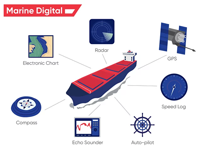
The evolution of maritime technology has profoundly transformed the way ships navigate and communicate, with modern vessels relying heavily on advanced Electronic Navigation Systems and Communications to ensure safe and efficient operations. For ship officers, understanding these systems is essential, as they form the backbone of maritime navigation and distress communication in today’s shipping industry. At maritime academies and universities, cadets receive thorough training in these systems, preparing them to manage a variety of scenarios at sea with precision and confidence.

Credit: Marine Digital
Key Electronic Navigation Systems
Electronic navigation systems have largely replaced traditional methods of navigation, offering ship officers precise, real-time data to aid in the safe navigation of vessels. Some of the most widely used electronic navigation systems include:
- Global Maritime Distress and Safety System (GMDSS)
The Global Maritime Distress and Safety System (GMDSS) is an internationally agreed-upon system for communication and ensuring safety at sea. GMDSS integrates various types of communication equipment, such as VHF (Very High Frequency), MF/HF (Medium/High Frequency), and satellite communications, to provide real-time distress alerts, ship-to-ship communication, and ship-to-shore communications. Every officer is trained to use GMDSS to manage distress situations and ensure compliance with international safety regulations.GMDSS can automatically send distress signals when a vessel is in danger, ensuring that search and rescue operations can be initiated promptly, even in extreme weather or emergencies.
- Electronic Chart Display and Information System (ECDIS)
One of the most revolutionary advancements in maritime navigation, ECDIS integrates electronic navigational charts with real-time position data from the ship’s GPS, providing an accurate and detailed view of the ship’s position relative to the coastline, hazards, and other vessels. ECDIS allows officers to plan and monitor voyages, reducing the need for traditional paper charts.Officers trained in ECDIS are adept at using the system for route planning, monitoring the ship’s progress, and avoiding hazards such as shallow waters or restricted areas. ECDIS also generates alarms when the ship deviates from its planned route or approaches a danger zone, enhancing safety.
- Automatic Radar Plotting Aids (ARPA)
ARPA is a vital component of radar navigation that helps officers automatically track and plot the movement of surrounding vessels. This system calculates critical information such as a vessel’s course, speed, and Closest Point of Approach (CPA) to determine the risk of collision. ARPA enables officers to take appropriate action in time to avoid collisions in busy shipping lanes or poor visibility conditions.ARPA is integrated with radar systems, giving officers the ability to track multiple targets simultaneously, making it particularly useful in congested waters.
- Automatic Identification System (AIS)
AIS is a tracking system that provides real-time information on nearby vessels, including their identity, position, speed, and course. It broadcasts this information automatically to surrounding vessels and shore stations, enabling officers to have a clear picture of the maritime traffic in their vicinity.AIS is critical for preventing collisions, especially in crowded waterways, and plays a key role in maintaining safe distances between ships. Officers are trained to interpret AIS data, cross-checking it with other navigational systems to make informed decisions.
- Global Positioning System (GPS)
GPS is a satellite-based navigation system that provides accurate data on the ship’s position, speed, and direction. GPS is integrated into many other navigational systems, including ECDIS, AIS, and ARPA, offering officers real-time information to guide their decisions during navigation.Officers are trained not only to use GPS but also to understand its limitations, such as signal interference or outages, and to rely on backup navigation methods if necessary.
Radar Plotting and Interpretation
Radar systems are indispensable for ship navigation, especially in low visibility conditions such as fog, storms, or nighttime. Radar emits radio waves that reflect off objects, enabling officers to detect nearby ships, landmasses, or obstacles and determine their distance, direction, and speed.
Officers must be skilled in radar plotting, which involves manually or automatically plotting the positions of other vessels on a radar screen to predict their future positions and assess collision risks. This skill is particularly valuable in busy shipping lanes or restricted waters, where quick decision-making is essential.
Radar interpretation also plays a vital role in determining weather patterns, allowing officers to track storm systems and plan routes accordingly to avoid dangerous conditions.
Communication Systems: Essential Tools for Safety and Coordination
Effective communication is vital for coordinating ship operations and ensuring safety. Modern ships are equipped with advanced communication systems that allow ship-to-ship and ship-to-shore communication over vast distances.
- VHF/MF/HF Radio Systems
VHF (Very High Frequency) radios are widely used for short-range communication, typically within 20 to 30 nautical miles. They are essential for communicating with other vessels, port authorities, and coastal stations. Officers use VHF radios for exchanging navigational information, such as traffic movement or docking instructions, and for sending and receiving distress signals.MF/HF (Medium/High Frequency) radios are used for long-range communication, often over hundreds or thousands of nautical miles. These systems are essential for communicating with shore stations or other vessels when sailing on the open ocean. Officers must be proficient in operating these systems and understanding radio frequencies to maintain reliable communication across different distances.
- Satellite Communication (SATCOM)
SATCOM provides global coverage for ship communication, enabling vessels to stay in contact with shore-based operations centers and other ships regardless of their location. Satellite communication is indispensable for long voyages, particularly in remote areas where traditional radio signals may not reach.Officers are trained to use satellite communication systems to manage routine operational communications and handle emergencies. SATCOM is also integrated into the GMDSS, ensuring that distress signals are relayed to the appropriate authorities no matter where the ship is located.
- Search and Rescue Transponders (SART)
SART is a key piece of equipment used in emergency situations to locate ships or lifeboats in distress. When activated, SART emits a signal that is detected by nearby radar systems, allowing rescue teams to pinpoint the ship or life raft’s exact location.Officers must be familiar with how to activate and operate SART in case of emergencies, ensuring quick and effective search and rescue operations.
Training and Certification
To ensure the safe and effective use of electronic navigation and communication systems, maritime academies and universities provide comprehensive training in these technologies. Officers undergo theoretical and practical training in the operation, interpretation, and limitations of each system, learning how to integrate them into daily navigational tasks. Certification in systems such as ECDIS, GMDSS, and ARPA is often mandatory for officers on merchant ships, ensuring that they have the skills and knowledge to manage modern navigational challenges and emergencies effectively.
Integration and Redundancy
One of the strengths of modern electronic navigation systems is their integration with one another. For example, ECDIS can receive data from GPS, radar, and AIS, providing a consolidated and real-time view of the vessel’s position, surroundings, and traffic conditions. This integration enables officers to cross-check information and make more informed decisions, enhancing overall safety. However, officers are also trained to recognize the limitations and potential failures of electronic systems. Redundancy is built into navigation operations to ensure that if one system fails (such as GPS signal loss), other systems like radar or traditional celestial navigation methods can still be used to safely navigate the vessel.
Conclusion
Electronic navigation and communication systems are at the heart of modern maritime operations, providing ship officers with the tools they need to navigate safely, communicate effectively, and respond to emergencies. From advanced systems like ECDIS and ARPA to communication tools such as GMDSS and SATCOM, these technologies enable precise navigation and enhance the safety of vessels at sea. Through rigorous training and certification programs, maritime officers are equipped to manage these systems and integrate them into their daily navigational responsibilities. As technology continues to evolve, electronic navigation and communication systems will remain an essential aspect of maritime education, ensuring that ship officers are prepared to face the challenges of modern shipping with confidence and competence.

