
Explore the critical comparison between ECDIS and paper charts. This 3,800-word guide covers operational pros/cons, SOLAS compliance, and hybrid best practices for safe, modern navigation.

For centuries, the navigator’s world was defined by the rustle of paper, the smell of ink, and the precise art of plotting a position by hand on a traditional paper chart. This tactile practice, honed over generations, represented not just a method but a philosophy of navigation—deliberate, physical, and deeply human. Today, that world is illuminated by the soft glow of digital screens. The Electronic Chart Display and Information System (ECDIS) has moved from a novel aid to the primary means of navigation for most large commercial vessels, mandated by the International Maritime Organization (IMO). This shift is more than technological; it represents a fundamental change in how mariners perceive and interact with their environment. Yet, the transition is not a simple replacement. It creates a complex operational landscape where understanding the strengths, limitations, and compliance requirements of both systems is not academic—it is a critical component of maritime safety. This article delves into the core of this evolution, providing navigation officers and maritime professionals with a clear-eyed comparison to inform safer practice and smarter decision-making on the bridge.
Why the ECDIS vs. Paper Charts Debate Still Matters
The question is often framed as “old versus new,” but in reality, it is about integrating legacy wisdom with modern capability. While ECDIS carriage is now standard under the International Convention for the Safety of Life at Sea (SOLAS), paper charts have not vanished. Regulations still permit, and in some cases require, backup paper charts. More importantly, the skills and mindset cultivated through paper chart navigation remain vital. They form a critical foundation for detecting ECDIS errors, managing system failures, and maintaining true situational awareness. Incidents investigated by bodies like the UK Marine Accident Investigation Branch (MAIB) and the US Coast Guard (USCG) frequently cite over-reliance on ECDIS or a fundamental misunderstanding of its settings as contributing factors. Conversely, a total rejection of digital tools ignores their immense power to prevent accidents. Therefore, for today’s maritime professional, this comparison is essential. It is about building a robust, layered approach to navigation where the officer can harness the efficiency of digital while retaining the resilient, fundamental skills of the analog world. This balanced understanding is key to navigating not just waters, but also the human factors and regulatory complexities of modern seafaring.
The Foundational Shift: From Static Plot to Dynamic System
To understand the comparison, one must first appreciate the philosophical difference between the two mediums. A traditional paper chart is a static, authoritative snapshot. It is a printed representation of a geographic area at a specific point in time, based on surveys that may be years or even decades old. The navigator manually adds dynamic information—the ship’s position, courses, and fixes—using tools like parallel rulers, dividers, and pencil. This process is slow, deliberate, and inherently spatial, requiring constant mental calculation and visualization.
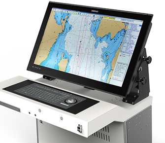
In stark contrast, ECDIS is a dynamic, integrated system. It is a computer-based navigation tool that synthesizes real-time data from the Global Navigation Satellite System (GNSS), gyrocompass, speed log, and radar. It displays this information over an Electronic Navigational Chart (ENC), which is a vector database of chart features. The system can perform automatic calculations, trigger alarms, and continuously update the vessel’s position. The transition, therefore, is from an active plotting process to a monitoring and management process. This shift changes the cognitive load on the officer, emphasizing system management and alarm response over manual dexterity and continuous plotting.
Operational Comparison: A Detailed Look at Pros and Cons
Advantages of ECDIS: The Digital Edge
The operational benefits of a properly functioning and expertly operated ECDIS are transformative, offering leaps in efficiency and proactive safety.
Enhanced Situational Awareness and Safety: The core advantage of ECDIS is its ability to create a real-time, integrated picture. The vessel’s precise position is continuously displayed on the chart. Key safety parameters, such as the safety contour and safety depth, can be set by the user. The system then monitors these automatically, providing visual warnings and audible alarms if the vessel is approaching shallow water, an isolated danger, or a designated area. This provides a proactive safety net that is impossible with paper, where the officer must mentally calculate all clearances. The integration of Automatic Identification System (AIS) targets directly onto the chart display further enriches this picture, clarifying traffic situations.
Unmatched Efficiency in Voyage Planning and Execution: Planning a complex voyage across multiple paper charts is a time-consuming physical task. With ECDIS, the entire route can be constructed, adjusted, and stored digitally. The system can automatically check the planned route against a database of charted features, highlighting potential conflicts. During the voyage, functions like automatic track-keeping and real-time Estimated Time of Arrival (ETA) calculations reduce routine workload. Updates to the ENC cells are applied via weekly digital files, eliminating the laborious and error-prone process of hand-correcting paper charts.
Advanced Functionality and Data Integration: ECDIS unlocks functionalities that are simply not possible on paper. The mariner can instantly adjust the display, turning layers of information (like lights, depth sounds, or specific navigational marks) on or off to reduce clutter. The ability to overlay and integrate data from radar images and other sensors creates a unified navigational view. Furthermore, the system records the entire voyage for playback and analysis—a invaluable tool for training and accident investigation.
Advantages of Traditional Paper Charts: Enduring Strengths
Despite the digital advance, paper charts possess inherent qualities that ensure their continued relevance, particularly as a robust backup and a tool for cultivating fundamental skills.
Tangibility, Reliability, and Independence: A paper chart requires no electricity, software, or GPS signal. It is a physically resilient and independent information source. In the event of a total power failure, network malfunction, or GNSS outage (including spoofing or jamming incidents), a paper chart, a magnetic compass, and a sextant provide a fail-safe means of navigation. This independence is a cornerstone of maritime safety philosophy. The chart’s information is permanently visible and cannot be obscured by screen clutter, improper settings, or a malfunctioning display.
Cultivation of Core Navigational Skills: The manual process of plotting on paper develops an intuitive, spatial understanding of navigation. Officers learn to visualize scale, distance, and relative movement in a fundamental way. This ingrained knowledge is crucial for quickly identifying gross errors in electronic systems—such as an incorrect geodetic datum setting or a faulty position feed—that might otherwise go unnoticed by someone reliant solely on a digital display. The act of physically drawing a line and writing a position reinforces a deeper cognitive engagement with the voyage’s geography.
Unambiguous Display and Simplicity: A paper chart presents all its information simultaneously, without menus, layers, or zoom levels that can hide critical details. There is no risk of an “overscale” or “underscale” warning; the mariner always sees the chart at its printed scale. This simplicity eliminates a category of user-error specific to ECDIS, where a dangerous feature might be missed because the display was not zoomed in to an appropriate level during planning or monitoring.
Limitations and Risks: The Flip Side of Each System
An honest appraisal must also confront the weaknesses and inherent risks associated with both methods.
ECDIS Limitations: The sophistication of ECDIS introduces new and complex risks. Over-reliance and complacency are the most significant human factor dangers. Officers may develop a “watch the screen” mentality, neglecting visual lookout and radar observation, in violation of the International Regulations for Preventing Collisions at Sea (COLREGs). The system’s safety is also entirely dependent on correct data and configuration. An improperly set safety contour or an outdated ENC cell can provide a deadly false sense of security. Alarm fatigue is another serious issue; poorly managed systems can generate numerous nuisance alarms, leading watchkeepers to silence or ignore critical warnings. Finally, ECDIS represents a cybersecurity target, as its digital nature makes it potentially vulnerable to malware or malicious interference.
Paper Chart Limitations: The drawbacks of paper are well-documented but remain relevant. The information is static and potentially outdated from the moment it is printed, relying on the diligence of manual corrections. The process is inherently slower for both planning and real-time navigation, which can be a disadvantage in high-traffic or dynamic situations. Human error in manual plotting—a misread bearing, a miscalculated distance—is a persistent risk. Furthermore, storing and handling a full portfolio of corrected charts for a global voyage is a significant physical and administrative burden.

The Compliance Landscape: SOLAS, Carriage Requirements, and the “Backup” Debate
The regulatory framework governing the use of ECDIS and paper charts is established by the IMO under SOLAS Chapter V, Regulation 19. This regulation mandates the carriage of ECDIS for most large commercial vessels on international voyages (typically cargo ships over 10,000 GT and all passenger ships). When a vessel is fitted with a type-approved ECDIS using official, up-to-date ENCs, it may be granted a waiver from carrying paper charts for the areas covered by the ENCs, provided a functional backup arrangement is in place.
This “backup” is a central point of operational practice and debate. The regulations allow for two primary backup options:
-
A second, independent ECDIS unit.
-
A full folio of updated paper charts for the intended voyage.
The choice between these backups is not trivial. A second ECDIS, while technologically elegant, may share common-mode failure points with the primary system (e.g., power supply, central GNSS receiver). Paper charts, while independent, require rigorous manual updating and crew proficiency. The International Chamber of Shipping (ICS) and classification societies like DNV and Lloyd’s Register provide guidelines emphasizing that the backup must be ready for immediate use. This means that if paper charts are the backup, they must be out, corrected, and plotted with the vessel’s current position at all times—a standard that is operationally challenging to maintain. Many companies now opt for the dual-ECDIS configuration for its consistency and to avoid the dual-task burden on watchkeepers.
Furthermore, the Standards of Training, Certification and Watchkeeping (STCW) Code mandates specific training for officers in charge of a navigational watch using ECDIS. This includes both generic and type-specific model courses, underscoring that proficiency cannot be assumed.
Case Study: The Grounding That Highlighted the Hybrid Imperative
A real-world incident underscores the critical need to understand both systems. In one well-documented grounding, a bulk carrier was approaching a port in challenging tidal conditions. The officers were reliant on the ECDIS display. However, a series of compounding factors led to the accident:
-
The safety contour was set incorrectly, providing no alarm as the vessel moved into shallow water.
-
The watchkeeper was primarily monitoring the ECDIS display, which was at a scale that did not clearly show the narrowing channel and turning point.
-
The paper chart for the area was available in the portfolio but was not being used as a parallel reference. It was stored away, not updated, and crucially, not consulted.
The subsequent investigation by the flag state and the European Maritime Safety Agency (EMSA) found that if the paper chart had been actively used in parallel—as a “sanity check” against the digital display—the officers might have recognized the developing discrepancy between the planned track on ECDIS and the more detailed, tangible geography visible on the paper chart. The accident was not caused by ECDIS failure, but by over-reliance on a single source of information and the failure to employ a layered, hybrid approach to navigation. This case powerfully argues that paper charts, even on a fully digital bridge, should not be seen as mere historical artifacts but as active, independent tools for verification.
Future Outlook: The S-100 Revolution and the Evolving Role of the Navigator
The digital transition is far from complete. The maritime industry is on the cusp of the next major leap: the shift from the current S-57 ENC standard to the new S-100 Universal Hydrographic Data Model. This will enable what is often termed “ECDIS 2.0.”
S-100 supports a richer, more interoperable environment. Future ECDIS will be able to seamlessly integrate various data products:
-
S-101: The next-generation ENC, with improved symbology and intelligent display.
-
S-102: High-density bathymetry, allowing for a 3D view of the seabed.
-
S-111: Surface currents, integrating real-time oceanographic data.
-
S-124: Navigational warnings in a machine-readable format.
This evolution will further expand the capabilities of ECDIS, making it an even more powerful hub for situational awareness. However, it will also increase system complexity and the potential for information overload. In this future, the role of the navigation officer will evolve further from a plotter to a data manager and systems analyst. The foundational skills of critical thinking, spatial reasoning, and risk assessment—skills honed by both paper and basic ECDIS practice—will become more valuable than ever. The officer will need to intelligently filter and interpret multiple data streams to make informed decisions.
Concurrently, the concept of the “backup” will also evolve. It may involve resilient digital systems, cloud-based chart services, or advanced integrated bridge designs that eliminate single points of failure. Yet, the philosophical principle of maintaining an independent means of position-fixing and navigation will remain a cornerstone of safety, even if its technological form changes.
FAQ: ECDIS and Paper Charts in Practice
1. Is my vessel allowed to sail without any paper charts on board?
Yes, but only under specific conditions. SOLAS permits a paper chart waiver if the vessel is fitted with a fully compliant, type-approved ECDIS using official, updated ENCs, and has an approved backup arrangement. This backup must be functional and ready for immediate use, which is often a second ECDIS. The final decision rests with the vessel’s flag state administration.
2. What are the biggest mistakes officers make when switching from paper to ECDIS?
The most common and dangerous mistakes are complacency (watching the screen instead of keeping a visual lookout), improper configuration of safety parameters (like safety contour and depth), and failure to perform basic system checks (verifying position source, ENC edition, and update status). Relying solely on ECDIS without cross-checking is a critical error.
3. How should paper charts be used on a bridge with a fully functional ECDIS?
Paper charts should be used as an active parallel tool, not a passive backup in a drawer. For critical phases of navigation (coastal passages, pilotage waters), the relevant paper chart should be out, updated, and used to independently verify the ECDIS route and the vessel’s position. This practice provides a crucial layer of validation.
4. What happens if the ECDIS fails during a voyage?
The vessel must immediately switch to its approved backup system. If that is a second ECDIS, operations continue. If the backup is paper charts, the watch team must transition to traditional navigation using those charts, which is why it is essential that they are already plotted and the crew is proficient in their use. The incident must be logged and reported.
5. Are the skills for paper chart navigation still relevant for new cadets?
Absolutely. Training on paper charts is foundational. It builds an irreplaceable geospatial understanding, reinforces the basics of chart symbols and geodesy, and cultivates the meticulousness required for safe navigation. These skills enable an officer to understand what the ECDIS is calculating and to detect when it might be wrong.
6. Who is responsible for ensuring ENC updates are applied to the ECDIS?
The Master is ultimately responsible for the vessel’s navigational safety. However, the task of procuring and applying the weekly ENC updates is typically assigned to a designated navigation officer. The process must be documented in the vessel’s logs. Using uncorrected ENCs invalidates the system’s compliance with SOLAS.
7. With the rise of “ECDIS 2.0” and more automation, will the navigator’s role become obsolete?
No. Automation will handle routine tasks and data synthesis, but the need for human judgment, management, and ultimate responsibility will increase. The future navigator will be a systems manager, a risk analyst, and a decision-maker, especially in high-stakes, complex, or emergency situations where predefined algorithms may fail.
Conclusion: Embracing a Synergistic Mindset for Safer Seas
The journey from the chart table to the digital workstation is irreversible, but the destination is not a world where one tool completely eradicates the value of the other. The most effective modern navigation strategy is synergistic, not exclusive. ECDIS offers unprecedented power for efficiency and proactive risk management. Traditional paper charts provide timeless resilience, independence, and a foundation for core seafaring skills.
For the professional navigation officer, the goal is not to choose a side in a historical debate, but to achieve mastery of both domains. This means leveraging the digital capabilities of ECDIS to their fullest while actively maintaining the disciplined practices of traditional navigation. It means using the paper chart as a vital cross-check, not a forgotten relic. It means understanding that compliance is the minimum standard, but true safety is built on layered verification, continuous learning, and a humble respect for the sea’s dangers. As we sail into an era of increasing digital integration with S-100 and beyond, let the lessons from both paper and pixel guide us toward safer, smarter, and more confident navigation.
References
-
International Maritime Organization (IMO). (2024). SOLAS Chapter V: Safety of Navigation. https://www.imo.org/en/OurWork/Safety/Pages/SOLAS-Chapters.aspx
-
International Hydrographic Organization (IHO). (2023). *S-100: The Universal Hydrographic Data Model*. https://iho.int/en/s-100-universal-hydrographic-data-model
-
UK Marine Accident Investigation Branch (MAIB). (2021). Report on the investigation of the grounding of MV XXX. https://www.gov.uk/maib-reports
-
International Chamber of Shipping (ICS). (2022). Bridge Procedures Guide, 6th Edition. https://www.ics-shipping.org/publication/bridge-procedures-guide-6th-edition-2022/
-
DNV. (2023). Maritime Navigator: ECDIS Backup Requirements. https://www.dnv.com/expert-story/maritime-impact/
-
European Maritime Safety Agency (EMSA). (2022). Annual Overview of Marine Casualties and Incidents. https://www.emsa.europa.eu/accident-investigation-publications.html
-
The Nautical Institute. (2020). The Human Element in ECDIS. Alert! Bulletin. https://www.nautinst.org/resource-library/alert-bulletins.html