
Meta Description: Learn ARPA vs AIS for traffic awareness: how radar tracking and AIS data complement each other, their limitations, and best watchkeeping practices.
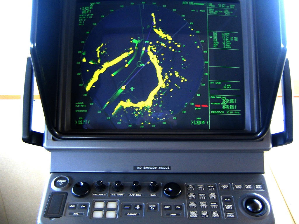
Imagine you are the officer of the watch on a container ship approaching a coastal traffic separation scheme at 02:30. It is a clear night, but the sea is busy: fast ferries, fishing vessels, and deep-sea traffic all share the same water. On the bridge, the radar picture is alive with echoes. Some are strong and stable. Some are weak and “jumping” as sea clutter changes. At the same time, the AIS overlay shows ship names, call signs, courses, and speeds—clean, readable, and confident.
This is where many watchkeepers meet a tempting trap: “AIS looks clear, so AIS must be right.” In reality, safe navigation depends on understanding that ARPA and AIS are different technologies with different strengths, failure modes, and legal implications. ARPA is built on what your radar actually detects in the real world. AIS is built on what other vessels (or shore networks) report digitally. Used together, they create a strong traffic awareness picture. Used incorrectly, they can create blind spots and misplaced confidence.
This article explains ARPA vs AIS in a practical, bridge-focused way. You will learn how each system works, why they sometimes disagree, and how competent watchkeepers combine them under COLREGs and STCW expectations.
Why This Topic Matters for Maritime Operations
Traffic awareness is a direct safety driver. Collision investigations and safety bulletins repeatedly show that accidents can occur even on well-equipped ships because the bridge team either over-relied on one sensor, did not cross-check information, or did not use ARPA tracking effectively when radar targets were visible. Recent safety reporting continues to highlight cases where a target was visible on radar but not acquired on ARPA, or where electronic navigation aids were not optimally monitored during a developing close-quarters situation. For example, a UK MAIB report on a collision notes that a target was visible on both radars but had not been acquired by ARPA, alongside other poor monitoring practices (a pattern seen across multiple investigations) (MAIB report page).
ARPA and AIS in One Sentence Each
ARPA (Automatic Radar Plotting Aid) is radar-based target tracking that calculates relative motion, vectors, CPA, and TCPA from measured radar echoes.
AIS (Automatic Identification System) is VHF digital reporting that broadcasts vessel identity and navigation data such as position, course, and speed for display on ships and at shore services.
Both can show you “traffic.” But the traffic picture is built from different foundations—measurement versus reporting—and that difference explains nearly everything that matters on watch.
How ARPA Works
ARPA is “Measured Reality” from Radar
Your radar sends pulses and receives echoes. ARPA takes those echoes and applies tracking algorithms to follow a target across successive scans. When a target is acquired, ARPA estimates the target’s relative course and speed compared to your own ship. From there it predicts CPA and TCPA.
A helpful analogy is to think of radar as a camera that takes a picture every few seconds, and ARPA as software that tracks moving cars in those images. If the camera image is noisy (rain clutter, sea clutter, interference), the tracking becomes unstable. ARPA does not magically “know” the ship; it learns movement from repeated observation.
What ARPA Typically Provides to the Watchkeeper
On most modern ARPA radars (meeting IMO performance standards), you can expect the system to provide target vectors, CPA/TCPA, and tracking status, plus alarms. ARPA is specifically intended to support collision avoidance decision-making, but it is still a decision-support tool—your judgement remains central.
Why Good Radar Tuning Matters More Than Most People Think
ARPA depends on radar detection quality. If gain is too low, weak targets will not be detected consistently. If sea clutter suppression is too high, small boats close to the ship may be suppressed. If rain clutter filtering is excessive, targets behind heavy rain can disappear or become intermittent.
In other words: a “clean” radar screen is not always a “good” radar screen. Sometimes a screen looks clean because the operator filtered out real targets.
ARPA’s Strengths
ARPA’s biggest advantage is that it can track non-cooperative targets. A vessel does not need to transmit anything for radar to detect it. If it reflects radar energy, it can appear—ships, small craft, rain squalls, land, offshore structures, even floating objects under the right conditions.
ARPA also remains useful when a vessel transmits incorrect AIS data or turns AIS off (where legally permitted in exceptional security circumstances). ARPA can still show a physically present target.
ARPA’s Weaknesses
ARPA’s weaknesses appear when detection is difficult or tracking is unstable. Small wooden boats, low-freeboard craft, targets masked by sea clutter, targets close to land, and targets in heavy rain can be challenging. ARPA also needs time to stabilise after acquisition; CPA/TCPA values can “dance” early in the track.
Finally, ARPA only knows what the radar sees—so if radar horizon, shadow sectors, interference, or wrong settings hide a target, ARPA cannot compensate.
How AIS Works
AIS is “Reported Reality” via Digital Messages
AIS uses VHF data links to transmit ship information automatically. The IMO describes AIS as a system that transmits and receives vessel information and is required for certain ship categories under SOLAS carriage requirements (e.g., passenger ships, and cargo ships above tonnage thresholds), with global implementation completed by the end of 2004 (IMO AIS overview).
AIS messages typically include:
- Static data (e.g., ship name, MMSI, IMO number)
- Dynamic data (e.g., position, course over ground, speed over ground, heading)
- Voyage-related data (e.g., draught, destination, ETA) depending on equipment and updates
A simple analogy: AIS is like a driver broadcasting their license plate, car type, and GPS position to everyone nearby. It is powerful for identification and coordination, but it is only as accurate as the GPS and the data entered or configured.
Why AIS Feels “Cleaner” Than Radar
AIS information is text and symbols generated from digital messages. It is not affected by sea clutter or rain in the same way as radar. That clarity can be psychologically persuasive. When a watchkeeper sees a stable AIS vector, it can feel more trustworthy than a noisy radar echo—even though the radar echo is the direct measurement of a real object.
AIS Strengths
AIS excels at identification and communication. You can immediately know which vessel is which, often including call sign and destination. AIS also supports shore services and Vessel Traffic Services (VTS). IALA guidance describes AIS use cases including display of traffic on ECDIS/radar and provision of information to VTS for monitoring routes and risk analysis (IALA AIS overview guideline, via USCG Navcen).
AIS is also helpful for targets that are difficult to see on radar (for example, a ship behind rain clutter or a small target with a weak radar cross-section), assuming it is transmitting accurate AIS.
AIS Weaknesses
AIS is cooperative and data-dependent.
First, AIS only shows vessels (or aids to navigation) that transmit AIS. Not all small craft carry AIS, and fishing vessels may have varying compliance depending on region, vessel size, and local regulation.
Second, AIS information can be wrong. Position can be offset if the GPS antenna position is entered incorrectly. Heading can differ from course over ground in strong current. Data such as draught and destination may be outdated or manually entered incorrectly.
Third, AIS can be intentionally misconfigured or turned off in some security contexts, although SOLAS ships are generally expected to keep AIS in operation except where international agreements, rules, or standards provide for the protection of navigational information (IMO AIS overview).
Finally, AIS can be subject to VHF channel congestion in high-density areas, resulting in delayed updates or missed messages.
ARPA vs AIS: The Practical Differences that Matter on Watch
1) Detection vs Identification
ARPA answers: “Is there a target physically present, and what is its relative movement?”
AIS answers: “Who is the target (if it is transmitting), and what does it report about itself?”
This is why radar/ARPA is often the first tool for collision avoidance risk assessment, while AIS supports identification and coordination.
2) Independent Sensing vs Dependent Data
ARPA depends on your radar and sensors. AIS depends on other ships’ transmitters, GPS inputs, and correct configuration.
When ARPA and AIS disagree, the watchkeeper’s job is not to choose the “prettier” display. The job is to investigate why the disagreement exists.
3) Relative Motion vs Reported Motion
ARPA calculates motion relative to your own ship (unless set to true motion modes). AIS typically reports true motion data (COG/SOG) from the target’s GNSS. In current, wind, or manoeuvring, the difference between heading, course, and rate of turn becomes significant.
A classic example is a ship crabbing across a strong tidal stream. AIS may show course over ground consistent with the stream, while radar shows the ship’s actual heading and relative motion. If you do not understand the difference, you can misunderstand passing distance and encounter geometry.
4) Update Behaviour and “Latency”
Radar scans update the picture regularly (depending on scan rate and range). AIS update intervals depend on message type and vessel dynamics, and may be less frequent for slow-moving targets. In busy VHF environments, AIS messages can be delayed.
This matters in close quarters: a delayed AIS position can make a target appear slightly “behind” its true position, while radar shows it in real-time (subject to radar resolution).
5) Failure Modes: What Can Go Wrong
ARPA failure modes: poor radar tuning, clutter, shadow sectors, target swap in close proximity, loss of tracking, sensor input errors.
AIS failure modes: wrong manual data, GNSS antenna offset errors, delayed messages, spoofed or incorrect identity, switched off transmitter, not fitted.
A competent watchkeeper expects failure modes and builds a habit of cross-checking.
Complementary Use: How Skilled Watchkeepers Combine ARPA and AIS
The “Two-Source Rule” for Critical Decisions
A good mental model is the two-source rule: for collision avoidance decisions, confirm critical information using at least two independent sources whenever possible.
For example, if AIS shows a vessel with a small CPA, confirm the radar echo and acquire the target on ARPA. If radar shows a target but AIS does not, investigate: is it a non-AIS vessel, an AIS failure, or a radar artefact?
A Practical Bridge Workflow
On many bridges, the most effective workflow is:
- Detect with radar and acquire on ARPA (build tracking confidence).
- Identify with AIS (ship name, type, intention clues from destination/route).
- Cross-check vectors and CPA/TCPA (do they align in both systems?).
- Validate with visual lookout (when possible) and with ECDIS context.
- Communicate early (bridge team, VHF if appropriate, VTS).
This is not a rigid checklist. It is a living process that adapts to visibility, traffic density, and navigational constraints.
Using AIS Carefully for VHF Calling
AIS makes it easy to call a ship by name, which can support collision avoidance coordination, especially in restricted visibility. But professional practice avoids “informal VHF agreements” that conflict with COLREGs.
A safe approach is to use AIS mainly for identification, while keeping manoeuvring decisions grounded in COLREGs and verified sensor information.
AIS Overlays on Radar: Helpful but Dangerous if Misunderstood
Many modern radars can overlay AIS symbols on the radar picture. This is useful for quick correlation, but it can create a subtle risk: an AIS symbol may appear exactly on top of a radar echo even when it is slightly offset due to time delay or GPS antenna configuration.
If you treat the overlay as “perfect truth,” you may miss a separate radar-only target nearby or fail to notice that the AIS symbol does not perfectly match the radar echo shape and movement.
A simple bridge habit helps: periodically turn the AIS overlay off for a few minutes and look at the raw radar picture. This resets your perception and ensures you are not navigating only through labels.
Key Developments and Modern Context
Integrated Bridge Systems and Sensor Fusion
Modern ships increasingly use integrated bridge systems where radar/ARPA, AIS, ECDIS, and conning displays share data. This is powerful, but integration can hide the independence of sources. If AIS is fed into multiple displays, the same wrong AIS data can look “confirmed” across the bridge, when it is actually a single-source error.
Good bridge teams remember which data comes from where. They also recognise that a sensor fusion display is not the same as independent verification.
e-Navigation and VDES
The maritime sector is evolving beyond classical AIS to broader digital exchange concepts. IALA work on the VHF Data Exchange System (VDES) describes an expanded approach to protect AIS and support e-Navigation and other digital communications in the VHF maritime band (IALA VDES overview).
For watchkeepers, the practical message is simple: digital data traffic will grow, but it will not remove the need for radar-based detection and tracking. More data can improve awareness, yet it can also increase the risk of information overload and over-trust.
Challenges and Practical Solutions
ARPA vs AIS is not mainly a technical debate; it is a watchkeeping discipline issue. The first challenge is complacency. AIS can feel like a complete traffic picture, especially when it draws neat vectors and labels. The solution is professional scepticism: assume any single sensor can be wrong, and prove its reliability through cross-checking.
A second challenge is misinterpretation of motion. AIS shows COG/SOG; ARPA often shows relative vectors. New officers sometimes compare these numbers directly and become confused. The solution is to understand the reference frame. If needed, switch the ARPA display mode (relative/true) and confirm that the bridge team agrees on what they are looking at.
A third challenge is target management in dense traffic. In high density, ARPA can lose tracks or swap targets if echoes merge. The practical solution is to manually acquire targets of concern, maintain appropriate range scales, and avoid over-filtering radar returns. Do not allow the ARPA list to become a “numbers exercise.” Instead, focus on the few targets that define the risk picture.
Finally, there is the challenge of bridge resource management under fatigue. Fatigue encourages shortcut thinking: “The AIS looks fine.” Strong teams counter this with standard verbal calls: “Target acquired on ARPA,” “CPA trending down,” “AIS and radar correlated,” and “Cross-check with ECDIS.” These phrases are simple, but they keep the team aligned.
Case Studies and Real-World Applications
A recurring theme in accident reporting is not that equipment failed, but that equipment was not used optimally. In a recent MAIB report, the investigators recorded that a target was visible on both radars, yet it had not been acquired by ARPA, alongside other weaknesses in monitoring electronic navigation aids (MAIB report page).
This kind of case is valuable because it shows how errors can look “small” on the bridge. An officer may see a target on the screen and assume that is enough. But without ARPA acquisition, you lose stable CPA/TCPA trend monitoring and alarms. If you then rely on AIS for risk assessment, you may miss a non-transmitting vessel or misinterpret a target whose AIS data is delayed or wrong.
In contrast, strong watchkeeping cases often show the opposite pattern. The officer uses radar to detect and confirm the target, acquires it on ARPA early, and then uses AIS to identify the vessel and understand its route. When the systems disagree, the officer investigates rather than choosing one blindly. This investigative habit is one of the best markers of professional competence.
Future Outlook and Maritime Trends
Traffic awareness is moving toward richer digital ecosystems. AIS data is now widely used ashore for safety analytics, routeing measures, and environmental monitoring. Digital communication upgrades such as VDES are intended to support e-Navigation and reduce pressure on existing AIS channels (IALA VDES overview).
At the same time, radar technology continues to improve through better signal processing and target discrimination. The future bridge will likely present more fused information, with stronger decision-support layers.
But one trend is unlikely to change: collision avoidance remains governed by COLREGs, and those rules assume that navigators use all available means to assess risk. That means using both measurement-based awareness (radar/ARPA) and reported-data awareness (AIS), verifying each against the other, and maintaining human judgement at the centre.
FAQ
Is AIS more accurate than ARPA for target position?
AIS position is typically GNSS-based and can be very precise, but it depends on correct antenna offsets and reliable transmissions. ARPA position is radar-measured and reflects what is physically detected. In practice, the most reliable approach is to correlate both and investigate any mismatch.
Can I use AIS alone for collision avoidance?
No. AIS supports collision avoidance, but it does not replace radar/ARPA and visual lookout. Some vessels may not transmit AIS, and AIS data can be wrong or delayed. Use AIS as an aid, not a primary “single source.”
Why does AIS show a different course than ARPA?
AIS often shows course over ground (COG), while ARPA may show relative motion vectors or true vectors depending on settings. In current, wind, or manoeuvring, heading, COG, and relative motion can diverge.
What should I do if a radar target has no AIS?
Treat it as a real contact until proven otherwise. Acquire the target on ARPA, monitor CPA/TCPA trends, and use additional tools (visual lookout, ECDIS context, VHF safety calls if appropriate) to clarify the situation.
Why do ARPA CPA/TCPA values change after I acquire a target?
ARPA needs time and multiple scans to stabilise tracking. Early values may fluctuate. Continue monitoring and confirm trends rather than reacting to a single early reading.
Does AIS always transmit the ship’s heading?
Not always. AIS may transmit heading if connected to a heading sensor, but it can be unavailable or inaccurate if sensors are misconfigured. Many AIS displays show both heading and COG/SOG; watchkeepers should understand what each means.
Are AIS overlays on radar safe to rely on?
They are useful but should be treated as an aid. Overlays can hide mismatches and encourage over-trust. Regularly review the raw radar picture and confirm correlation.
Conclusion and Take-away
ARPA vs AIS is not a competition. It is a partnership.
ARPA gives you a measured picture of the real world: echoes, motion, and collision prediction from radar tracking. AIS gives you identity and reported navigation data: names, positions, and digital context for communication and planning. When used together—actively, sceptically, and with professional judgement—they create a strong traffic awareness system that supports safe, compliant navigation.
If you are training cadets or building bridge team culture, the simplest best practice is this: never trust one screen alone. Correlate radar and AIS. Acquire targets early on ARPA. Watch the trend, not just the number. And keep the human navigator—alert, curious, and disciplined—at the centre of the system.
References
International Maritime Organization. (n.d.). AIS transponders. https://www.imo.org/en/ourwork/safety/pages/ais.aspx
International Association of Marine Aids to Navigation and Lighthouse Authorities. (2016). IALA Guideline 1082: An overview of AIS (Ed. 2.0). https://www.navcen.uscg.gov/sites/default/files/pdf/IALA_Guideline_1082_An_Overview_of_AIS.pdf
International Association of Marine Aids to Navigation and Lighthouse Authorities. (2023/2025). VHF Data Exchange System (VDES) Overview (Guidance). https://events.iala.int/content/uploads/2025/02/G1117-Ed3.0-VHF-Data-Exchange-System-VDES-Overview.pdf
Marine Accident Investigation Branch. (2024). Collision between general cargo vessel Scot Explorer and gas carrier Happy Falcon. https://www.gov.uk/maib-reports/collision-between-general-cargo-vessel-scot-explorer-and-gas-carrier-happy-falcon
International Maritime Organization. (2004). Revised performance standards for radar equipment (MSC.192(79)) (Resolution). https://wwwcdn.imo.org/localresources/en/KnowledgeCentre/IndexofIMOResolutions/MSCResolutions/MSC.192%2879%29.pdf
United States Coast Guard Navigation Center. (n.d.). SOLAS Chapter V, Regulation 19.2 – carriage requirements (AIS and navigation equipment references). https://www.navcen.uscg.gov/sites/default/files/pdf/AIS/SOLAS.V.19.2.1-5.pdf