

Master essential ECDIS operations, safety settings, and the upcoming S-101 standard. This 3,300+ word guide for navigation officers balances professional depth with globally accessible English. Stay safe and compliant.
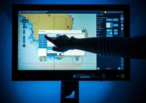
In the dim light of the bridge, the soft glow of a digital screen has replaced the rustle of paper charts. This transition from centuries-old navigation methods to the Electronic Chart Display and Information System (ECDIS) represents one of the most profound shifts in seafaring history. For the modern navigation officer, ECDIS is far more than a simple digital map; it is the integrated command center for voyage planning, execution, and safety monitoring. Its mandatory carriage on most large commercial vessels underscores its critical role, yet its complexity demands more than basic familiarity. True mastery requires a deep understanding of its principles, a disciplined approach to its settings, and a vigilant awareness of its limitations. As the industry stands on the brink of a new era with the S-100 data framework and “ECDIS 2.0,” a solid grasp of the basics is the essential foundation upon which future skills must be built. This guide unpacks the core knowledge every deck officer needs to operate ECDIS safely, efficiently, and with professional confidence.
Why ECDIS Mastery is Non-Negotiable for Modern Navigation
The implementation of ECDIS as a primary means of navigation was a milestone aimed at significantly enhancing maritime safety. By integrating the vessel’s real-time position with an electronic navigational chart (ENC), it provides a continuously updated situational picture that paper charts cannot match. It automates tasks like position fixing and warning alarms, potentially reducing human error. However, this advanced capability introduces a new risk: complacency and over-reliance. The system is only as good as the officer using it. A series of grounding incidents investigated by authorities like the UK’s Marine Accident Investigation Branch (MAIB) consistently highlight improper ECDIS use as a causal factor. These accidents often stem not from system failure, but from a fundamental misunderstanding of safety settings, poor voyage planning procedures, or a failure to maintain a proper lookout separate from the screen. Therefore, for the navigation officer, proficiency with ECDIS is not just a regulatory checkbox under the Standards of Training, Certification and Watchkeeping (STCW) Code; it is a core professional competency that directly safeguards the vessel, its crew, and the environment. It transforms the officer from a passive plotter to an active manager of navigational intelligence.
Core Concepts and Components: Understanding the System
Before engaging with the menus and settings, it is crucial to understand what ECDIS is and what it comprises. At its heart, ECDIS is a computer-based navigation system that complies with International Maritime Organization (IMO) performance standards. It must be type-approved by a recognized authority (like a classification society) to be used as the primary means of navigation, allowing for the legal waiver of paper charts.
The system’s functionality rests on three pillars: hardware, software, and data. The hardware includes the main display unit, typically one or more ruggedized computers or workstations on the bridge, and critical sensors like the Global Navigation Satellite System (GNSS) receiver for position, and inputs from the gyrocompass, speed log, and Automatic Identification System (AIS). The software is the proprietary ECDIS application that processes this data. However, the most critical component is the data: the Electronic Navigational Chart (ENC).
ENCs are vector charts issued by official hydrographic offices (like the UKHO or NOAA). Unlike simple raster scans of paper charts, ENCs contain “intelligent” geospatial data where every point, line, and area (like a buoy, coastline, or depth area) is an object with attributes stored in a database. This allows ECDIS to perform intelligent functions, like triggering an alarm if the vessel’s safety contour is breached. Understanding that you are working with a dynamic database, not a static picture, is key to using ECDIS effectively. The market for these integrated systems is growing robustly, with a projected compound annual growth rate (CAGR) of 8.5% from 2026 to 2033, driven by increased maritime trade and technological advancement.
The Evolution to S-100 and ECDIS 2.0: What’s Next?
The ECDIS you use today is largely based on the S-57 data format for ENCs, a standard developed in the 1990s. The maritime world is now transitioning to a new, more powerful framework: S-100. This is not just an update to the chart format; it is a universal hydrographic data model designed to support a wide range of marine information products beyond the traditional ENC.
The next-generation ENC under this framework is known as S-101. For the navigation officer, S-101 ENCs will offer tangible improvements aimed at reducing cognitive load and enhancing safety:
-
Intelligent Text Placement: Text on charts will be automatically positioned to avoid clutter and overlap, allowing you to keep more information displayed without a messy screen.
-
Improved Buoyage Symbology: Buoys will be shown with color-coded symbols, matching what you see visually out the window, for faster recognition.
-
Reduced Alarm Fatigue: Features will be encoded more intelligently to minimize false or unnecessary alarms, a common complaint that can lead to warnings being ignored.
-
Enhanced Cyber Resilience: The data pipeline from shore to ship will have improved security and authentication.
Furthermore, S-100 enables the seamless layering of additional data sets, such as S-102 (high-density bathymetry for a 3D view of the seafloor) and S-111 (surface currents). This integration paves the way for what is being termed “ECDIS 2.0,” a more immersive and information-rich navigation workstation.
The transition is already underway. IMO’s new performance standard will allow for the fitting of S-100-enabled ECDIS from 2026, with all new installations required to be S-100 compatible from 2029. For today’s navigation officer, this means that a firm grasp of current ECDIS basics is the essential foundation for adapting to this next-generation technology.
Practical ECDIS Operations: From Planning to Watchkeeping
Voyage Planning
A comprehensive and careful voyage plan is the bedrock of safe navigation, and in the ECDIS era, this process is both empowered and demanding. The plan must be constructed in the ECDIS itself, not on paper and then transferred. Key steps include:
-
Route Creation: Plotting waypoints with sufficient sea room. Each leg must be checked against the safety settings.
-
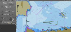
Setting Safety Parameters: This is the most critical step. The safety contour must be set appropriately for the vessel’s draught, accounting for squat and under-keel clearance. The safety depth and deep/shallow contours should be configured to give a clear visual picture of the seabed. Zones like the cross-track limit (XTL) and guard zones must be set to provide meaningful warnings.
-
Visual and Data Inspection: The officer must visually scan the entire route at a large scale (“zooming in”) to check for obstructions, isolated dangers, or changes in charted data that might fall between waypoints. The system’s “Check Route” function is a tool, not a replacement for this detailed human review.
Voyage Monitoring and Watchkeeping
During the watch, ECDIS becomes the primary situation display. The officer must:
-
Maintain Situational Awareness: Use the ECDIS in conjunction with radar and visual lookout. The tendency to fixate on the screen is a known risk. The display orientation (North-up or Course-up) and motion mode (True or Relative motion) should be selected based on the navigational situation.
-
Interpret the Display Correctly: Understand what each color, symbol, and line style represents. Recognize the difference between a “dangerous” symbol that triggers an alarm and an “informational” symbol.
-
Respond to Alarms Judiciously: Every alarm must be acknowledged, understood, and acted upon appropriately. Silencing an alarm without addressing its cause is a direct path to an incident. The case of the bulk carrier grounding in the narrow strait, where an audible alarm was disconnected and a visual alarm went unnoticed, is a stark lesson in alarm management failure.
System Setup and Data Management
The integrity of the system depends on proper setup and maintenance:
-
Position Integrity: Verify that the correct position source (e.g., primary GPS) is selected and that the built-in Receiver Autonomous Integrity Monitoring (RAIM) or similar checks are active.
-
Chart Management: Ensure all ENCs for the voyage are loaded and updated with the latest weekly updates. The system must show that it is operating on “official” data to be used as the primary system. A chart folio should be created and managed systematically.
-
Backup Arrangements: Regulations require a functional backup for the primary ECDIS. This could be a second independent unit, or a fully updated paper chart portfolio. Officers must be proficient in using the backup system.
Critical Safety Settings and Common Pitfalls
Misconfigured safety settings are a root cause of many ECDIS-related groundings. Two of the most critical and commonly misunderstood settings are the Safety Contour and the Safety Depth.
The Safety Contour is a user-selected depth contour (e.g., 10m, 20m) from the ENC database. ECDIS highlights this contour and will trigger an alarm if the vessel is predicted to cross it based on its course and speed. A fatal error is setting the safety contour to a depth less than the vessel’s draught. For example, in one grounding incident, the vessel had a sailing draught of 10.63 meters but the safety contour was set to 10 meters. This meant the vessel would strike the seabed at 10.13 meters before ever crossing the safety contour and triggering an alarm. The safety contour must always be set to a depth greater than the vessel’s maximum draught, with an added safety margin for squat and sea state.
The Safety Depth is a different, but related, setting. It is a single depth value you enter. ECDIS will then shade all areas shallower than this safety depth in a distinctive color (often blue or gray). This provides an immediate, at-a-glance visual reference of unsafe waters. It should be set with a similar conservative margin.
Other pitfalls include:
-
Over-reliance on the “Look-Ahead” or Anti-Grounding Function: This function only scans along the vessel’s planned route. If the vessel deviates from the planned route, as in the case where an officer altered course early to avoid traffic, the look-ahead sector may no longer be scanning the area into which the vessel is actually heading.
-
Improper Scaling: Not zooming in sufficiently during route planning or monitoring can cause you to miss small but critical charted features like isolated rocks or wrecks.
-
Ignoring the “Awareness” Indicators: ECDIS has states like “NO SHOW” or “OVERSALE” that warn when information is missing or the display is too zoomed-out for safe navigation. Disregarding these states is negligent.
The Indispensable Human Factor: ECDIS as a Tool, Not a Pilot
Technology can create a dangerous illusion of infallibility. The most sophisticated ECDIS is a decision-support tool, not an autonomous pilot. The human officer remains the final authority and is responsible for safe navigation. This demands:
-
Continuous Professional Judgment: Cross-checking the ECDIS position with other methods (radar fixes, visual bearings) is a fundamental discipline that must not be lost.
-
Effective Bridge Resource Management (BRM): The Master and OOW must communicate clearly about ECDIS settings, route modifications, and alarm responses. The Master in the grounding case failed in this duty by being distracted with administrative tasks at a critical moment.
-
Type-Specific Training: Generic ECDIS training is a start, but it is insufficient. Officers must receive familiarization on the specific make and model of ECDIS installed on their vessel, as menus, functions, and alarms can vary significantly between manufacturers.
-
Maintaining a Proper Lookout: Rule 5 of the COLREGs is not suspended by ECDIS. The view outside the window, radar observation, and listening for sound signals remain paramount. Background noise, like loud music on the bridge, can mask both audible alarms and external sounds, degrading the lookout.
Preparing for the Future: Skills for the Next Decade
The role of the navigation officer is evolving alongside the technology. To stay relevant and effective, officers should focus on developing these forward-looking competencies:
-
Data Integration Skills: Future ECDIS will be a hub for multiple S-100 data layers. Officers will need to know how to interpret and use overlays like real-time high-density bathymetry or dynamic surface current predictions to optimize routes and enhance safety.
-
Cybersecurity Awareness: As navigation systems become more connected for chart updates and data streaming, they become potential cyber targets. Officers must understand basic cyber hygiene principles, such as the importance of “air-gapped” systems separating navigation networks from crew welfare internet access.
-
Adaptability to Connectivity: The proliferation of Low Earth Orbit (LEO) satellite constellations like Starlink is providing high-bandwidth, low-latency connectivity at sea. This enables real-time data exchange between ship and shore, potentially involving shoreside teams in monitoring and decision support. Officers must be comfortable operating in this connected environment.
-
Understanding the Autonomous Pathway: While fully autonomous ships are not imminent, the technology is being developed. S-100 data is explicitly designed to be machine-readable for Maritime Autonomous Surface Ships (MASS). Today’s navigation officers who deeply understand ECDIS and the data that drives it will be the essential experts shaping and overseeing those future systems.
–
FAQ: ECDIS Basics for Navigation Officers
1. I am certified on one type of ECDIS. Am I qualified to use any system?
No. While generic training provides foundational knowledge, type-specific familiarization is legally and operationally required. Controls, menu structures, and alarm management can differ greatly between manufacturers (e.g., Transas vs. Furuno vs. JRC). You must receive training on the specific equipment fitted on your vessel.
2. How often should I update my ENCs, and what happens if I don’t?
ENCs must be updated with the latest weekly corrections issued by the hydrographic office. If updates are not applied, the ECDIS is no longer operating on “official” data and cannot be used as the primary means of navigation. Using outdated charts is a severe safety risk and a clear violation of SOLAS regulations.
3. What is the single most important ECDIS safety setting to check before a voyage?
The Safety Contour. An incorrectly set safety contour provides a false sense of security and disables a primary anti-grounding alarm. Always verify it is set to a depth greater than your vessel’s maximum draught plus a safety margin.
4. My ECDIS shows an alarm, but I visually see no danger. What should I do?
Never ignore or blindly silence an alarm. First, acknowledge it to stop the audible signal. Then, investigate meticulously: Zoom in on the alarm location on the display, check the object’s attributes, verify your vessel’s position with a second method (e.g., radar range), and assess the situation visually and on radar. Only after confirming it is a false or non-critical alarm should you silence it, and remain vigilant.
5. What is the biggest human error associated with ECDIS use?
Complacency and over-reliance. The most common error is trusting the system so completely that officers stop cross-checking information, fail to maintain a proper lookout outside the window, or neglect basic navigational principles. ECDIS is a tool to aid a skilled navigator, not a replacement for one.
6. When will I need to start using the new S-101 ENCs?
The transition is phased. S-100-enabled ECDIS units can be fitted from 2026, and all new ECDIS installations must be S-100 compatible from 2029. Existing S-57 ENCs will be supported for many years, but you should seek training on S-100 features as they become available on your vessels.
7. Does ECDIS reduce the workload on the bridge team?
It can, by automating tasks like position plotting. However, it also changes the nature of the workload, demanding higher-level system management, data analysis, and alarm response skills. It is not a tool for reducing qualified crew numbers but for enhancing the quality of navigational decision-making.
Conclusion: The Officer in the Loop
The journey to ECDIS proficiency is continuous. From mastering today’s fundamentals of safety contours and voyage planning to adapting tomorrow to the integrated, data-rich environment of S-100, the navigation officer’s role is more vital than ever. Remember, every alarm ignored, every safety setting guessed, and every cross-check skipped is a step toward an incident. Use this system with respect for its power and awareness of its limits. Commit to lifelong learning, engage deeply with your type-specific equipment, and never let the digital display dim your professional judgment and watchkeeping instincts. The safe and efficient voyage depends, now as always, on you.
References
-
UK Hydrographic Office (UKHO). (2025, February 25). *S-101: The next generation of Electronic Navigational Charts (ENCs)*. Admiralty. https://www.admiralty.co.uk/news/s-101-next-generation-electronic-navigational-charts-encs
-
Marine Insight. (n.d.). Real Life Accident: Improper Bridge Procedures And ECDIS Use Causes Grounding of Ship. Retrieved February 2, 2026. https://www.marineinsight.com/case-studies/mproper-bridge-procedures-ecdis-use-caused-grounding/
-
Wingrove, M. (2025, December 31). 2026 in maritime optimisation and communications: key digitalisation technologies to transform shipping. Riviera Maritime Media. https://www.rivieramm.com/opinion/opinion/2026-in-maritime-optimisation-amp-communications-key-digitalisation-technologies-transforming-shipping-87061
-
Oihta Marine. (n.d.). AI, IoT, and Maritime Technology Trends for 2026. Retrieved February 2, 2026. https://oithamarine.com/the-digitalization-of-the-seas-ai-iot-and-maritime-technology-trends-for-2026/
-
Britannia P&I Club. (2023, February 2). BSAFE INCIDENT CASE STUDY 18: IMPROPER ELECTRONIC CHART DISPLAY AND INFORMATION SYSTEM (ECDIS) SETUP LEADS TO GROUNDING. https://britanniapandi.com/2023/02/bsafe-incident-case-study-18-improper-use-of-ecdis-leads-to-grounding/
-
Consilient MR. (n.d.). The Commercial ECDIS System Market Analysis Report Forecasts Market Trends from 2026 to 2033 with a Projected CAGR of 8.5%. LinkedIn. https://www.linkedin.com/pulse/commercial-ecdis-system-market-analysis-report-forecasts-n7izf
-
Cognitive Market Research. (n.d.). ECDIS Market Analysis 2026. https://www.cognitivemarketresearch.com/ecdis-market-report
-
Riviera Maritime Media. (2009, November 26). Owners stress the practical challenges of moving to ecdis. https://www.rivieramm.com/news-content-hub/news-content-hub/owners-stress-the-practical-challenges-of-moving-to-ecdis-46558
-
Ideagen. (n.d.). *Maritime digital transformation trends for 2026 and real-time monitoring ROI*. https://www.ideagen.com/thought-leadership/blog/maritime-digital-transformation-trends-for-2026-and-real-time-monitoring-roi