

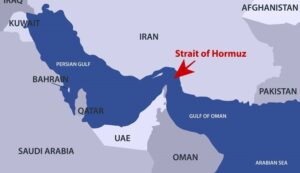
The Strait of Hormuz is one of the world’s most strategically significant maritime passages. Located between the Iran to the north and Oman and the United Arab Emirates to the south, this narrow waterway forms the only sea connection between the Persian Gulf and the open ocean through the Gulf of Oman(Mokran) and the Arabian Sea.
Despite its relatively limited width, the Strait of Hormuz has an outsized influence on global geopolitics, maritime transportation, energy security, naval operations, and regional economics. Roughly one-fifth of the world’s traded crude oil and a significant share of liquefied natural gas (LNG) pass through this route every day. For this reason, it is often described as the world’s most critical maritime chokepoint.
The strait is not only an energy corridor but also a complex maritime environment shaped by unique geography, sensitive ecosystems, intense commercial shipping, military presence, fisheries, offshore oil activities, and environmental pressures. Navigating through the area requires careful voyage planning, compliance with traffic separation schemes, awareness of regional security risks, and understanding of meteorological and oceanographic conditions.
This article provides a comprehensive overview of the Strait of Hormuz, including its geographical profile, hydrography, shipping routes, territorial jurisdiction, environmental conditions, navigational hazards, historical background, and strategic maritime significance.
Geographic Location and Regional Setting
The Strait of Hormuz is situated in the Middle East at the southeastern entrance of the Persian Gulf. It connects the Persian Gulf with the Gulf of Oman and ultimately the Indian Ocean.
Geographically, the strait lies approximately between latitudes 26°N and 27°N and longitudes 55°E and 57°E.
Bordering Countries
The strait is bordered by:
- Iran on the northern side
- Oman on the southern side through the Musandam Peninsula
- United Arab Emirates nearby on the southwestern approaches
The Musandam Peninsula, an exclave of Oman separated from mainland Oman by UAE territory, dominates the southern side of the strait and creates steep mountainous coastlines overlooking the shipping lanes.
Origin and Meaning of the Name “Hormuz”
The name “Hormuz” is believed to derive from the ancient Persian word “Hormoz” or “Ormuz,” linked to Ahura Mazda (Hormazd), the supreme deity in Zoroastrianism. Historically, the region was associated with the prosperous Kingdom of Hormuz, which controlled maritime trade routes in the Gulf during medieval times.
The ancient trading port of Hormuz Island became one of the wealthiest commercial centers in the region due to its strategic location on East-West maritime trade routes.
European navigators during the Portuguese expansion of the 16th century referred to the waterway as the “Strait of Ormuz.”
Physical Characteristics of the Strait
Width
The Strait of Hormuz is relatively narrow:
- Approximately 167 km wide at its broadest point
- About 39 km wide at its narrowest navigable section
However, the actual shipping lanes used by large commercial vessels are much narrower.
Traffic Separation Scheme (TSS)
To reduce collision risks, the strait uses internationally recognized traffic separation schemes:
- One inbound lane
- One outbound lane
- Separation zone between them
Each navigational lane is only about 2 nautical miles wide, with an additional buffer separation zone of around 2 nautical miles.
This means that massive crude oil tankers, LNG carriers, container vessels, naval vessels, and bulk carriers often operate in relatively constrained waters.
Bathymetry and Water Depth
The Strait of Hormuz has varying depths depending on location.
General Depth Profile
Typical depths range between:
- 30 meters in shallower coastal areas
- More than 100 meters in deeper channels
The navigable channels used by deep-draft vessels are sufficiently deep for:
- Ultra Large Crude Carriers (ULCCs)
- Very Large Crude Carriers (VLCCs)
- LNG carriers
- Large container ships
However, draft limitations still require careful passage planning for heavily loaded vessels.
Seabed Composition
The seabed consists mainly of:
- Sand
- Silt
- Carbonate sediments
- Coral fragments
- Mud deposits in certain sheltered zones
The seabed topography can change gradually due to sediment transport and coastal hydrodynamic processes.
Water Currents and Oceanography
The hydrodynamics of the Strait of Hormuz are complex because it acts as the exchange channel between the Persian Gulf and the Indian Ocean.
Surface Current Patterns
Generally:
- Surface waters flow inward from the Gulf of Oman into the Persian Gulf
- Denser, saltier subsurface waters flow outward from the Persian Gulf toward the Indian Ocean
This creates a two-layer exchange circulation.
Current Speed
Typical current speeds range between:
- 0.5 knots
- 2 knots
However, stronger localized currents may occur due to:
- Tidal exchanges
- Seasonal winds
- Narrow channel effects
- Coastal bathymetry
These currents can affect:
- Ship maneuverability
- Pilotage operations
- Anchoring safety
- Oil spill movement
Tides in the Strait of Hormuz
The tidal regime is mixed and semi-diurnal.
Tidal Range
Typical tidal ranges are:
- Around 1–2 meters in most areas
- Occasionally higher under meteorological influences
Strong tidal streams may develop in narrow sections and around islands.
Tidal effects become operationally important for:
- Deep-draft tankers
- Tug operations
- Offshore terminals
- Small craft navigation
Wind and Weather Conditions
The Strait of Hormuz experiences harsh climatic conditions typical of the Arabian Gulf region.
Prevailing Winds
Shamal Winds
The “Shamal” is the dominant regional wind.
Characteristics include:
- Northwesterly direction
- Dry and dusty conditions
- Strong seasonal intensity
- Reduced visibility due to sand and dust storms
Shamal winds are strongest during:
- Summer months
- Transitional seasonal periods
Other Wind Systems
Additional local wind effects include:
- Sea breezes
- Mountain winds near Musandam
- Winter storm systems
Temperature and Climate
The region experiences extreme temperatures.
Summer Conditions
Air temperatures can exceed:
- 45°C
Sea surface temperatures may surpass:
- 34°C
Winter Conditions
Winter is milder but still warm relative to many maritime regions.
Visibility and Navigation Challenges
Navigation through the strait may be affected by:
- Dust storms
- Heat haze
- Humidity
- Fog during seasonal transitions
- Smoke from industrial activities
Reduced visibility can significantly affect:
- Radar interpretation
- Visual navigation
- Pilot boarding operations
- Collision avoidance
Shipping Routes and Vessel Traffic
One of the Busiest Maritime Routes in the World
The Strait of Hormuz is among the world’s busiest shipping corridors.
Major vessel types include:
- Oil tankers
- LNG carriers
- Container ships
- Naval vessels
- Bulk carriers
- Offshore support vessels
- Chemical tankers
Energy Transportation Role
The strait is critically important for global energy flows.
Major oil-exporting states relying on the strait include:
- Saudi Arabia
- Iraq
- Kuwait
- Qatar
- United Arab Emirates
- Iran
Qatar’s LNG exports especially depend heavily on uninterrupted passage through Hormuz.
Traffic Separation Scheme and Navigational Control
The International Maritime Organization (IMO) recognizes the Traffic Separation Scheme in the strait.
Operational Characteristics
Ships are required to:
- Follow designated lanes
- Maintain safe separation
- Observe collision regulations (COLREGs)
- Report according to regional requirements
Heavy traffic density demands:
- Continuous bridge watchkeeping
- Enhanced situational awareness
- Strict adherence to voyage plans
Islands Near the Strait of Hormuz
Several strategically important islands are located near the strait.
Iranian Islands
Important Iranian islands include:
- Qeshm Island
- Hormuz Island
- Larak Island
- Abu Musa
Omani Territory
The Musandam Peninsula of Oman forms the southern side of the strait.
Nearby features include:
- Khasab
Territorial Waters and Maritime Jurisdiction
The Strait of Hormuz passes through territorial waters claimed by Iran and Oman.
Strategic and Geopolitical Importance
Global Energy Security
The Strait of Hormuz is central to global oil and gas supply chains.
Any disruption can immediately affect:
- Oil prices
- Shipping insurance
- Freight rates
- Global energy markets
Because of this, the strait has enormous geopolitical sensitivity.
Military Significance
The region hosts heavy naval presence from:
- Iran
- United States
- Gulf Cooperation Council states
- Allied naval coalitions
Naval operations often include:
- Escort missions
- Surveillance
- Mine countermeasure operations
- Maritime security patrols
Economic Importance
The economies of many Gulf countries depend heavily on exports moving through the strait.
Major Gulf ports connected through Hormuz include:
- Port of Ras Tanura
- Port of Fujairah
- Port of Jebel Ali
- Port of Mina Al Ahmadi
Environmental and Ecological Characteristics
The Strait of Hormuz forms part of the broader Persian Gulf marine ecosystem.
Biodiversity
Marine life includes:
- Coral reefs
- Mangroves
- Dolphins
- Sea turtles
- Fish populations
- Plankton ecosystems
Despite harsh salinity and temperature conditions, the Gulf supports important biological diversity.
Salinity Levels
The Persian Gulf has extremely high salinity levels because:
- Evaporation exceeds freshwater input
- Limited river inflow
- Restricted water exchange
Salinity commonly exceeds:
- 40 PSU (Practical Salinity Units)
This affects marine ecosystems and water density circulation.
Coral Reef Stress
Regional coral reefs experience stress from:
- Rising sea temperatures
- Coastal development
- Sedimentation
- Oil pollution
Some coral species in the Gulf demonstrate unusual heat tolerance, making them scientifically important for climate resilience research.
Pollution in the Strait of Hormuz
Oil Pollution
The region is highly vulnerable to hydrocarbon contamination because of:
- Intensive tanker traffic
- Offshore oil infrastructure
- Refinery activities
- Operational discharges
- Accidental spills
Even minor spills can severely affect marine habitats.
Industrial Pollution
Sources include:
- Desalination plants
- Petrochemical industries
- Coastal urbanization
- Wastewater discharge
Air Pollution
Heavy marine fuel combustion contributes to:
- Sulfur oxides (SOx)
- Nitrogen oxides (NOx)
- Particulate matter
- Greenhouse gas emissions
Ballast Water and Invasive Species
High shipping density increases risks of:
- Invasive marine species
- Biological contamination
- Ecosystem imbalance
Ballast water management regulations are therefore operationally important in the region.
Maritime Hazards and Navigational Risks
Congested Traffic
The narrow shipping lanes create high collision risk.
Potential hazards include:
- Crossing traffic
- Fishing vessels
- High-speed military craft
- Dense tanker movement
Shallow Coastal Areas
Although main channels are deep, surrounding shallow areas increase grounding risks.
Security Threats
Regional geopolitical tensions occasionally create maritime security risks such as:
- Vessel seizures
- Drone threats
- Military confrontations
- Mining concerns
- Electronic interference
GPS and Electronic Interference
Ships have occasionally reported:
- GPS spoofing
- AIS anomalies
- Communication disruptions
These issues complicate navigation and situational awareness.
Major Maritime Incidents in the Strait of Hormuz
Tanker War (1980s)
During the Iran–Iraq War, commercial vessels in the Gulf became targets in the “Tanker War.”
Hundreds of merchant ships were attacked or damaged.
USS Vincennes Incident (1988)
In 1988, the USS Vincennes (CG-49) mistakenly shot down Iran Air Flight 655 over the Strait of Hormuz region, killing all onboard.
The incident remains one of the most controversial events in the region’s modern history.
Tanker Attacks and Sabotage Incidents
Several commercial vessels have experienced:
- Explosions
- Mine damage
- Drone-related threats
- Seizures
Such incidents significantly affect marine insurance and operational risk assessments.
Piracy and Armed Threats
Unlike regions such as the Gulf of Aden, classical piracy is less common in Hormuz.
However, security risks still exist from:
- Armed confrontations
- Political escalation
- Maritime interdictions
Offshore Oil and Gas Infrastructure
The surrounding Gulf region contains extensive offshore infrastructure.
Facilities Include
- Offshore platforms
- Single-point moorings
- Subsea pipelines
- Export terminals
This creates additional navigation complexity for passing vessels.
Fisheries and Local Maritime Communities
The strait supports traditional fishing communities in:
- Iran
- Oman
- UAE
Fishing vessels often operate near shipping routes, increasing navigational interaction with commercial traffic.
Role in Global Supply Chains
Any disruption in Hormuz affects:
- Oil prices
- LNG supply
- Shipping schedules
- Commodity markets
- Insurance premiums
Because modern economies depend heavily on uninterrupted energy transportation, the strait remains globally significant.
Alternative Energy Export Routes
Some Gulf countries have developed bypass pipelines to reduce dependence on Hormuz.
Examples include:
- Saudi East-West Pipeline
- UAE Abu Dhabi crude pipeline to Fujairah
However, these alternatives cannot fully replace the strait’s export capacity.
Maritime Regulations and Safety Measures
Shipping companies operating through Hormuz typically apply enhanced maritime security procedures.
Common Measures
- Increased bridge watch levels
- Citadel preparations
- BMP security guidance
- Naval coordination
- AIS monitoring policies
- Risk assessment protocols
Climate Change and Future Challenges
Climate change may intensify regional challenges through:
- Rising sea temperatures
- Coral reef degradation
- Stronger heatwaves
- Coastal vulnerability
- Water scarcity
Increased maritime activity may also worsen environmental pressures.
Technological Developments
Modern navigation through Hormuz increasingly relies on:
- ECDIS
- AIS
- Satellite navigation
- Real-time traffic monitoring
- Integrated bridge systems
- Maritime domain awareness systems
Naval and commercial operators both employ advanced surveillance technologies in the region.
The Strait of Hormuz in Maritime Strategy
For maritime strategists, the Strait of Hormuz represents:
- A critical chokepoint
- A geopolitical pressure point
- A global energy artery
- A naval operational zone
- A commercially indispensable sea route
Its strategic relevance continues to grow as global energy demand and regional tensions evolve.
Conclusion
The Strait of Hormuz is far more than a narrow maritime passage. It is one of the most important strategic waterways in modern history, serving as the primary gateway between the Persian Gulf and the wider world. Through this relatively confined corridor flows a substantial share of the world’s oil and LNG trade, making it central to global energy security and international commerce.
Its geographic characteristics — narrow navigation channels, variable depths, strong currents, extreme weather, and dense vessel traffic — create significant navigational and operational challenges. At the same time, its geopolitical environment introduces additional complexity through military activity, regional rivalries, and maritime security concerns.
Environmentally, the strait supports fragile marine ecosystems already under pressure from pollution, industrialization, offshore energy activities, and climate change. Balancing economic necessity with environmental sustainability remains one of the major challenges for the region.
From a maritime perspective, the Strait of Hormuz is a textbook example of how geography can shape international trade, naval strategy, marine environmental management, and global politics simultaneously. Its continued stability and safe navigability remain essential not only for Gulf states but for the functioning of the wider global economy.