
The Persian Gulf, a strategic and historically significant body of water, has long been a center of geopolitical interest due to its extensive oil reserves and prime location between the Arabian Peninsula and Iran. Covering an area of approximately 251,000 square kilometers (96,912 square miles), the gulf stretches about 990 kilometers (615 miles) from the Shatt al-Arab river delta in the northwest to the Strait of Hormuz in the southeast. In this article, we delve into the varying depths of the Persian Gulf, exploring its unique geography and its implications for regional and global maritime activities.
Credit: https://www.destinationiran.com/map-of-the-persian-gulf.htm
Geographical Overview
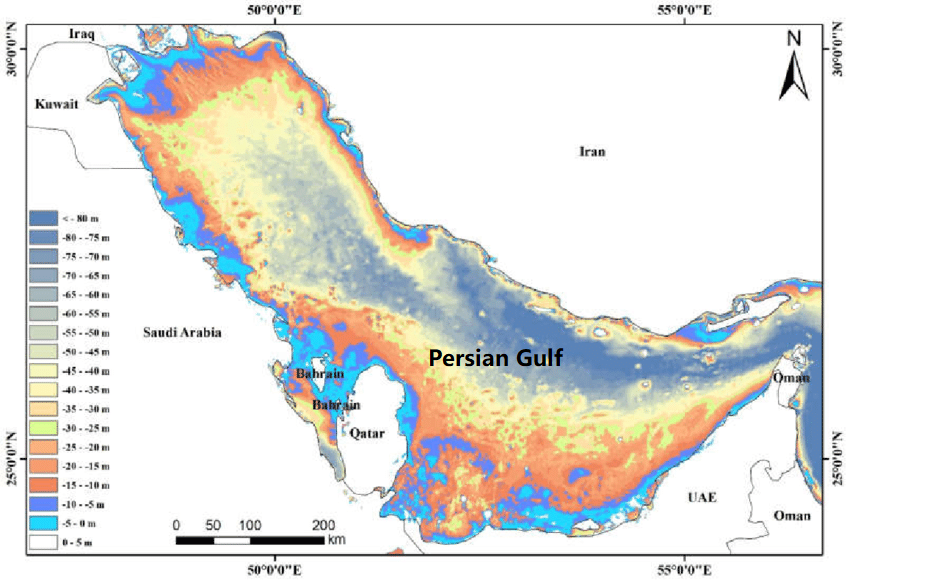
The Persian Gulf is a semi-enclosed, shallow, marginal sea, with an average depth of around 50 meters (164 feet) and a maximum depth of approximately 110 meters (361 feet) in its central basin. The gulf’s waters are generally shallow, with over 60% of the area being less than 30 meters (98 feet) deep. This shallow nature has significant consequences for navigation, marine life, and the extraction of resources such as oil and natural gas.
Depth Distribution in the Persian Gulf
The Persian Gulf’s depth varies significantly across its different regions, with notable differences between the Arabian and Iranian coasts. The following is a breakdown of the gulf’s depth in various areas:
Northwestern region (Shatt al-Arab delta): The gulf’s depth is at its shallowest near the Shatt al-Arab delta, with depths ranging from 2 meters (6.5 feet) to 10 meters (32.8 feet). This region is characterized by its extensive marshlands and riverine deposits from the Tigris and Euphrates rivers.
Arabian Coast: Along the Arabian coast, the gulf’s depth is relatively shallow, ranging from 10 meters (32.8 feet) to 40 meters (131 feet). The coastal waters are characterized by extensive sandbars, shoals, and coral reefs, which are home to diverse marine ecosystems. Major ports, such as Dammam in Saudi Arabia, have been dredged to accommodate large vessels.
Iranian Coast: The Iranian coast is generally deeper than the Arabian coast, with depths ranging from 30 meters (98 feet) to 70 meters (230 feet). This region is marked by a series of narrow coastal plains and the Zagros Mountain range, which influence the topography of the seabed.
Central Basin: The deepest part of the Persian Gulf lies in its central basin, with depths reaching up to 110 meters (361 feet). This area is of particular importance for the extraction of oil and natural gas resources, as well as for the development of artificial islands for drilling and production facilities.
Implications of Depth Variations
The varying depths of the Persian Gulf have several important implications for maritime activities, including shipping, fishing, and resource extraction:
- Shipping and navigation: The gulf’s shallow waters pose challenges for the navigation of large vessels, particularly oil tankers. Many ports have been dredged and deepened to accommodate these ships, and navigational aids such as buoys, beacons, and electronic charting systems are critical to ensure safe passage.
- Fishing and marine life: The shallow waters along the Arabian coast provide ideal habitats for diverse marine ecosystems, including coral reefs, seagrass beds, and mangroves. These areas are essential for the gulf’s fisheries, which are a vital source of food and income for the region’s coastal communities.
- Oil and natural gas extraction: The Persian Gulf is home to some of the world’s largest oil and gas reserves, and the depth of its waters plays a crucial role in the region.
Frequently Asked Questions (FAQ)
1. What is the average depth of the Persian Gulf?
The Persian Gulf has an average depth of around 50 meters (164 feet), with its deepest point reaching approximately 110 meters (361 feet) in the central basin. Over 60% of the gulf is less than 30 meters (98 feet) deep, making it a relatively shallow body of water.
📖 Learn more: Geographical Overview
2. Where is the deepest part of the Persian Gulf?
The deepest region of the Persian Gulf is the central basin, where depths reach up to 110 meters (361 feet). This area is crucial for oil and gas extraction and maritime navigation.
📖 Learn more: Depth Distribution in the Persian Gulf
3. How does the depth vary between the Arabian and Iranian coasts?
-
Arabian Coast: Shallow, ranging from 10 to 40 meters (32.8–131 feet), featuring sandbars, coral reefs, and major dredged ports.
-
Iranian Coast: Deeper, with depths between 30 to 70 meters (98–230 feet), influenced by the Zagros Mountains.
📖 Learn more: Depth Distribution in the Persian Gulf
4. Why is the Persian Gulf’s depth important for shipping and oil extraction?
-
Shipping: Shallow waters require dredging of ports and advanced navigational aids for large vessels.
-
Oil & Gas: The central basin’s depth allows for offshore drilling, while shallow coastal areas support nearshore rigs.
📖 Learn more: Implications of Depth Variations
5. What marine ecosystems thrive in the Persian Gulf’s shallow waters?
The Arabian coast’s shallow waters (10–40 meters deep) support coral reefs, seagrass beds, and mangroves, which are vital for fisheries and biodiversity.
📖 Learn more: Implications of Depth Variations
6. How does the depth affect navigation in the Persian Gulf?
Due to its shallow nature, large ships (especially oil tankers) rely on dredged channels, buoys, and electronic navigation systems to avoid sandbars and reefs.
📖 Learn more: Implications of Depth Variations
7. What is the shallowest part of the Persian Gulf?
The northwestern region near the Shatt al-Arab delta is the shallowest, with depths as low as 2 meters (6.5 feet), due to sediment deposits from the Tigris and Euphrates rivers.
📖 Learn more: Depth Distribution in the Persian Gulf
8. How does the Persian Gulf compare in depth to other major seas?
-
Persian Gulf: Avg. 50m (164 ft), Max. 110m (361 ft)
-
Red Sea: Avg. 490m (1,608 ft), Max. 3,040m (9,970 ft)
-
Mediterranean Sea: Avg. 1,500m (4,921 ft), Max. 5,267m (17,280 ft)
The Persian Gulf is much shallower than most major seas, impacting its maritime and ecological dynamics.
📖 Reference: Geographical Overview
–
References:
-
NOAA Ocean Depth Data (for comparative sea depths)