The Rise of BeiDou
China’s BeiDou Navigation Satellite System (BDS) has emerged as a formidable competitor to the U.S.-operated Global Positioning System (GPS), marking a pivotal shift in global navigation technology. With 140 countries now integrated into its network, BeiDou is no longer just a regional alternative but a strategic asset in China’s geopolitical and technological ambitions56.
Originally developed as a military project in the 1990s following a GPS blackout during the Taiwan Strait Crisis, BeiDou has evolved into a global navigation powerhouse, generating $79.9 billion in economic output in 2024—a 7.4% year-on-year increase6. Recognized by the United Nations as a global navigation provider, BeiDou now processes over one trillion location requests daily and guides four billion kilometers of navigation every day.

Source: https://www.youtube.com/watch?v=jqMAqS1Tqyk
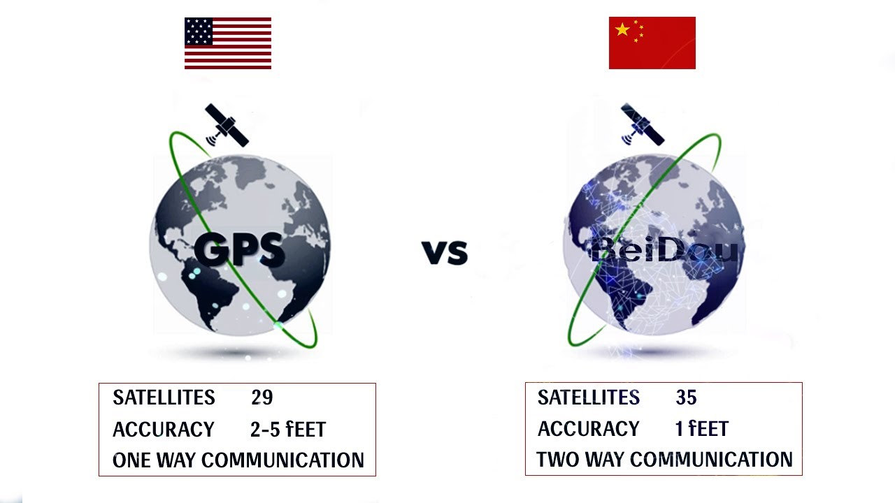
For nearly four decades, the U.S. dominated global satellite navigation through GPS, but a turning point came during the 1996 Taiwan crisis, when China claimed the U.S. disabled GPS signals, prompting it to develop an independent system. Today, China’s BeiDou Navigation Satellite System (BDS) rivals and, in some aspects, surpasses GPS, with a constellation of 35 satellites, enhanced accuracy, and unique services such as global short message communication and emergency rescue capabilities. BDS development serves China’s military ambitions—enabling autonomous missile guidance, precise targeting, and real-time command—and supports economic goals by boosting global technology adoption through the Belt and Road Initiative. By 2025, BDS is projected to be a $156 billion industry. Strategic partnerships, especially with Russia’s GLONASS, further enhance BDS resilience and global reach. The U.S. approved signal interoperability in 2017, acknowledging BDS’s growing importance. As China integrates BDS with 5G, AI, and smart infrastructure, it strengthens its position in global geopolitics, challenging the U.S.-centric world order and advancing its vision of a China-centered, interconnected future.
–
From Military Project to Global Navigation Leader
Origins and Development
-
1990s: Conceived as a military necessity after China realized its vulnerability to U.S. GPS denial during the Taiwan Strait Crisis4.
-
2000–2012: Launched BeiDou-1 (regional coverage) and BeiDou-2 (Asia-Pacific coverage)4.
-
2020: BeiDou-3 achieved global coverage, completing China’s three-step strategy4.
Key Achievements in 2024
-
288 million Chinese smartphones now integrate BeiDou, surpassing GPS in domestic adoption6.
-
99% coverage across China’s urban and rural roads with lane-level precision, outperforming standard GPS accuracy6.
-
56 satellites in orbit (nearly double GPS’s 31), enhancing signal strength and reliability13.
-
10 cm precision for military use, compared to GPS’s 3-meter civilian accuracy13.
–
Global Expansion: A Strategic Complement to GPS
While GPS remains the dominant global standard, BeiDou has gained traction in regions where U.S. coverage is weaker, particularly in the Global South.
Regional Adoption Highlights
-
Africa: Over 30 nations use BeiDou for precision agriculture, water management, and meteorology5.
-
Latin America: Major ports like Chancay (Peru) integrate BeiDou for smart navigation and logistics5.
-
Asia & Middle East: BeiDou supports transportation and maritime operations in areas where GPS signals are unreliable5.
China’s strategy is not to replace GPS outright but to offer a high-precision alternative, reducing reliance on U.S. technology while expanding its influence9.
Technological Independence and Diplomatic Leverage
BeiDou is more than a navigation system—it’s a tool of soft power and economic diplomacy.
Military and Strategic Advantages
-
Guaranteed access: BeiDou ensures China’s military operations are immune to U.S. GPS shutdowns9.
-
Precision-guided munitions: BeiDou’s 10 cm encrypted accuracy enhances missile and drone targeting13.
-
Surveillance capabilities: The two-way messaging feature allows real-time tracking, raising concerns about data security and espionage13.
Economic and Diplomatic Influence
-
Belt and Road Initiative (BRI): BeiDou is a key component of China’s “Digital Silk Road”, embedding its technology in partner nations’ infrastructure9.
-
Free global services: By offering BeiDou as a “public good”, China wins favor in developing nations, fostering technological dependency6.
–
The Future: Beyond Navigation
China is not stopping at BeiDou—it’s part of a broader push into AI, 5G, and green energy, reinforcing its vision of a China-led technological ecosystem.
Next-Generation BeiDou (2035 Plan)
-
Centimeter-level real-time positioning for deep-sea and high-altitude navigation6.
-
Enhanced global monitoring stations, further improving accuracy in the Southern Hemisphere11.
-
Integration with autonomous vehicles, drones, and smart cities6.
Challenges Ahead
-
Trust issues: Many nations remain wary of BeiDou’s dual-use (civilian-military) nature10.
-
GPS resilience: Despite BeiDou’s advancements, GPS retains global brand recognition and deep integration with Western tech.
–
Conclusion: A New Geopolitical Frontier in Navigation
BeiDou’s rise signifies a strategic shift in global tech dominance. By offering a viable alternative to GPS, China has:
-
Secured its technological independence from U.S. systems.
-
Expanded its geopolitical influence through infrastructure and diplomacy.
-
Positioned itself as a leader in next-generation PNT (Positioning, Navigation, and Timing) technologies.
The question now is not whether BeiDou will surpass GPS, but how the two systems will coexist in a multi-GNSS world. For now, one thing is clear: China’s era of satellite navigation leadership has arrived513.
Sources:

