
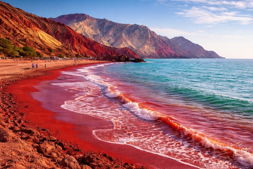

In December 2025, the shores of Iran’s strategic Hormuz Island in the Persian Gulf witnessed a startling transformation. Following seasonal rainfall, sections of its coastline turned a deep, vivid red, as if the sea itself was bleeding. This dramatic natural event, captured in viral satellite and drone imagery, sent ripples far beyond geological curiosity. For the maritime community, the reddening of Hormuz Island’s beach was not merely a spectacle; it was a vivid environmental signal, a case study in coastal dynamics, and a potent reminder of the intricate relationship between geology, climate, and safe navigation in the world’s most critical oil transit chokepoint. This article delves beyond the headlines to analyze the scientific causes of this phenomenon, unravel its direct and indirect implications for shipping, and explore what it teaches us about monitoring and adapting to environmental change in sensitive maritime regions.
Why the Hormuz Island Red Beach Phenomenon Matters for Maritime Operations
At first glance, a temporarily red beach might seem irrelevant to a tanker captain or a port manager. However, in the context of the hyper-strategic Strait of Hormuz, every environmental change carries operational significance. This event matters profoundly for several key maritime reasons. First, it is a stark visual indicator of extreme erosion and sediment mobilization. The processes that deposit red sediments on the beach also move vast amounts of material into the nearshore zone. This can lead to unexpected shoaling, altering bathymetry in areas that may not be surveyed frequently. For vessels navigating constrained waters, especially deep-draft crude carriers, even minor changes in seabed topography can pose grounding risks.
Second, the phenomenon highlights the intensifying impact of climatic volatility in a region known for its harsh environment. The Persian Gulf is experiencing changes in precipitation patterns, with projections from institutions like the World Bank indicating a trend towards more intense, sporadic rainfall events. These events trigger surface runoff and erosion, affecting water quality and clarity. Suspended sediments reduce underwater visibility, complicating underwater inspections, salvage operations, and increasing the risk of submerged object collisions. Furthermore, large influxes of freshwater and sediment can create localized water density gradients, affecting vessel handling and sensor accuracy, particularly for echo sounders.
Finally, such events trigger heightened scrutiny from environmental regulators and port state control. A sudden, visible change in coastal waters can lead to investigations to rule out pollution incidents, such as illegal discharge or algal blooms linked to ballast water transfer. Mariners must be prepared to report accurately on such conditions, distinguishing between natural phenomena and potential MARPOL Annex VI violations or hazardous situations. Understanding the cause is essential for accurate communication with Vessel Traffic Services (VTS) and coastal authorities, ensuring that operational decisions are based on fact, not alarm.
The Science Behind the Crimson Shore: Unpacking a Natural Phenomenon
The dramatic red hue that coated Hormuz Island’s beach is not a sign of pollution or a supernatural event, but a spectacular display of the island’s unique geology. Hormuz Island is famed for its otherworldly, multicolored landscapes, rich in mineral deposits. The key to the red beach lies in its soil and rock composition.
The island is home to a significant deposit of hematite, an iron oxide mineral that is the primary ore of iron. Hematite, with its characteristic red-brown to black color, is abundant in the island’s famous “Rainbow Mountains” and soil layers. In its natural, dry state, this iron-rich soil appears as reddish earth. However, the trigger for the December 2025 event was unseasonal or intense rainfall. When rain falls on these arid, sparsely vegetated slopes, it does not soak in easily. Instead, it becomes runoff, gathering force as it moves down gradients.
This runoff acts as a natural slurry pump. It erodes the surface soil, suspending and transporting the fine particles of red hematite and other colored clays. These sediment-laden streams then flow directly onto the beach and into the nearshore waters of the Persian Gulf. As the flow reaches the flatter coastline and meets the sea, its energy dissipates. The suspended particles, now heavier in the saltwater, settle out. The result is a deposition of a dense, red layer of iron oxide sediments across the sandy beach, creating the dramatic “red beach” effect. Once the rain stops and the sun returns, the water evaporates, leaving the stained sands behind until normal wave action slowly redistributes or disperses them.
This process is a classic example of accelerated erosion due to weather events. It is natural but can be exacerbated by human activity that removes stabilizing vegetation. Peer-reviewed studies in journals like Geomorphology and Marine Geology have documented similar sediment mobilization events in arid coastal zones worldwide, linking them to climate patterns. For maritime professionals, the core takeaway is this: the red beach is a visible symptom of a larger process—the rapid movement of land-based sediments into the marine environment.
Maritime Implications: From Navigation to Environmental Compliance
The transfer of terrestrial sediment into the marine domain has tangible consequences for shipping and offshore activities in the vicinity of Hormuz Island and similar geologies.
Navigational Safety and Hydrographic Concerns: The most immediate concern is the potential for alteration of seabed contours. The runoff and sedimentation event can create small, temporary deltas or fan deposits at the mouths of wadis (dry riverbeds). While major shipping lanes are farther offshore, support vessels, pilot boats, and smaller craft operating close to shore must be vigilant. Sediment plumes in the water column can also affect the performance of echo sounders. Acoustic signals can be scattered or absorbed by high concentrations of suspended particles, potentially giving false depth readings or obscuring submerged hazards. This underscores the importance of relying on updated Electronic Navigational Charts (ENCs) and using LIDAR or multibeam surveys where available, though these too can be impacted by water turbidity. The International Maritime Organization (IMO) emphasizes the use of all available means for safe navigation, and in such conditions, this includes increased visual lookout and caution when transiting recently affected areas.
Environmental Monitoring and Regulatory Reporting: From a bridge or a drone, a large red plume entering the sea can be mistaken for a chemical spill or a harmful algal bloom (HAB). It is crucial for the Officer of the Watch (OOW) to make a careful assessment. Distinguishing between a natural sediment plume (often linked directly to a rain event and a shoreline) and a potential pollution incident is a professional skill. Mariners have a duty under MARPOL and general practice to report any observed pollution incidents. However, accurate reporting is key. Misidentifying a natural geological event as an oil spill could trigger an unnecessary and costly emergency response from regional authorities like the ROPME Sea Area (RSA) emergency response center.
Conversely, assuming a red plume is only sediment when it might be a mix of sediment and contaminants from land-based sources is also a risk. The event highlights the need for robust environmental observation protocols on ships. Training, as outlined in IMO Model Courses, should include recognition of common natural phenomena in different regions. Furthermore, coastal states are likely to increase environmental surveillance after such visible events. Vessels may face more detailed questioning from Port State Control (PSC) officers under the Riyadh MoU regarding any ballast water or bilge discharges logged around that time, as authorities work to rule out anthropogenic causes for water discoloration.
Impact on Port and Coastal Infrastructure: For port authorities in the Persian Gulf, events like this are a reminder of watershed management. Sediment runoff can accumulate in dredged channels and basin berths, increasing maintenance dredging costs and frequency. It can also affect seawater intake systems for cooling or desalination plants at port facilities. Understanding local geology and rainfall patterns is part of long-term port resilience planning, a topic increasingly addressed by organizations like the International Association of Ports and Harbors (IAPH) and classification societies such as DNV, which offer guidelines for climate adaptation.
Challenges and Practical Solutions for the Maritime Industry
The Hormuz Island event encapsulates several broader challenges facing maritime operations in environmentally dynamic regions.
Challenge 1: The Data Gap Between Hydrographic Surveys and Rapid Environmental Change. Official nautical charts are incredibly accurate but are not updated in real-time. A significant weather event can change coastal bathymetry before the next survey cycle. This creates a period of uncertainty for navigators.
-
Practical Solutions: The industry is moving towards crowdsourced bathymetry and real-time data sharing. Initiatives supported by the International Hydrographic Organization (IHO) encourage vessels to contribute depth data from their standard echo sounders during transits. In sensitive areas, coastal VTS could issue temporary notices based on visual or satellite monitoring of sediment plumes, advising caution in specific near-shore zones. Increased use of autonomous surface vehicles (ASVs) for rapid post-event surveys is also a growing trend.
Challenge 2: Differentiating Natural Phenomena from Pollution Events. As seen, the visual signature of a sediment plume can be similar to certain types of pollution. Incorrect identification wastes resources or risks missing a real incident.
-
Practical Solutions: Enhanced training is fundamental. STCW competency requirements for “Maintaining a Safe Navigational Watch” include making a “proper appraisal” of the situation. This should be interpreted to include environmental observation. Onboard, the use of simple tools like a secchi disk to measure turbidity, or even collecting a small water sample in a clean jar for visual inspection, can provide clues. Collaboration with academic institutions can provide mariners with region-specific guides—”Is this a red tide or red clay?”—empowering them to make more informed reports.
Challenge 3: Integrating Climate Volatility into Risk Assessments. Traditional voyage planning uses historical climate data, but the increasing frequency of extreme weather events requires a more dynamic approach.
-
Practical Solutions: Shipping companies and ICS guidelines are increasingly advocating for passage planning that includes environmental risk overlays. This means considering not just storms, but also the secondary effects of heavy rainfall near sensitive coastlines, such as debris flow or sediment discharge. Weather routing services are now beginning to incorporate coastal erosion and runoff risk models into their advice, especially for vessels operating in sensitive or shallow areas.
Case Study: The 2025 Hormuz Event as a Real-World Application of ECDIS and Situational Awareness
Let us construct a hypothetical but realistic scenario to illustrate the application of maritime principles to this event. Imagine a product tanker on a routine passage from the UAE to Iraq, passing within visual range of Hormuz Island a day after the heavy rainfall.
The Scenario: The OOW observes a distinct, large reddish-brown plume extending from the island’s shoreline several cables out to sea. The plume is in an area not directly on the vessel’s track but close enough to warrant attention.
The Application of Maritime Systems & Training:
-
Initial Assessment: The OOW consults the Electronic Chart Display and Information System (ECDIS). They confirm there are no charted underwater pipelines or cables in the immediate area of the plume. They check the latest Navigational Warnings (NAVAREAs/NAVWARNS) broadcast for the Persian Gulf, finding no reports of pipeline leaks or pollution in that location.
-
Environmental Observation: Recalling training, the OOW notes the meteorological context: heavy rainfall was reported in the region 24 hours prior. They observe that the plume originates from specific drainage points on the island’s coast, not from a single point suggestive of a vessel or platform discharge. They log the observation in the ship’s deck logbook with details: position, extent, color, and their assessment: “Observed extensive sediment plume, likely terrestrial runoff from recent rainfall, consistent with island’s red soil geology.”
-
Risk Mitigation & Communication: As a precaution, the OOW adjusts course slightly to give the plume a wider berth, mitigating any risk of encountering abruptly shallower water or debris. They inform the master and ensure an additional lookout is posted if the plume is near the track. They do not issue a distress or urgency signal, as the situation does not pose an immediate threat to the vessel. However, they may choose to send a routine safety message to the regional UK Maritime Trade Operations (UKMTO) or the VTS Strait of Hormuz, reporting the observation for the awareness of other mariners and authorities.
-
Post-Voyage Reporting: The company’s safety management system (SMS) may have a procedure for reporting unusual environmental observations. The OOW’s detailed log entry provides valuable ground-truth data that could be shared with hydrographic offices or environmental agencies, contributing to the collective understanding of the area.
This case study demonstrates how standard maritime tools, training, and procedures enable professional mariners to respond calmly and correctly to a striking natural event, ensuring safety without unnecessary alarm.
Future Outlook: Climate, Monitoring, and Resilient Maritime Operations
The red beach of Hormuz Island in 2025 is a snapshot of the future. Climate models project an increase in the intensity of rainfall events in arid regions, even if total precipitation does not rise significantly. This means similar sediment mobilization events may become more frequent not only around Hormuz but in other geologically similar arid coasts worldwide.
The maritime response will hinge on technological integration and proactive planning. We can anticipate several trends:
-
Enhanced Earth Observation Integration: Satellite data from agencies like NASA and ESA, which clearly captured this event, will become more seamlessly integrated into maritime awareness platforms. Near-real-time turbidity and chlorophyll-a maps could become standard overlays in ECDIS or fleet operation centers, helping distinguish sediment from algal blooms.
-
AI-Powered Risk Prediction: Machine learning models, fed with historical weather, geological, and incident data, could provide predictive alerts for areas at high risk of rapid coastal change after forecasted heavy rain, allowing for pre-emptive route adjustments.
-
Focus on Coastal Zone Management (CZM): The International Maritime Organization (IMO) and regional bodies like ROPME will likely place greater emphasis on Integrated Coastal Zone Management in their guidelines. This encourages coastal states to manage watersheds to reduce sediment runoff, which benefits both marine ecosystems and navigational safety.
-
Classification Society Guidelines: Leading classification societies like Lloyd’s Register and ABS are already developing climate resilience notations and guidelines for ships and infrastructure. These will increasingly include criteria for operating in regions prone to rapid environmental change and sedimentation.
The vessels and ports of the future will need to be as adaptable as the environment they operate in. The 2025 Hormuz event is not a crisis; it is a lesson written in red sand—a call for the industry to sharpen its observational skills, integrate new data streams, and always respect the powerful, dynamic interface between land and sea.
Frequently Asked Questions (FAQ)
Q1: Was the red beach on Hormuz Island in 2025 caused by an oil spill or pollution?
A1: No, scientific assessment confirmed it was a natural geological event. Heavy rainfall eroded and transported naturally occurring red iron oxide minerals (hematite) from the island’s soil to the beach, depositing them as a vivid red layer. This was not a pollution incident.
Q2: As a mariner passing by, should I report such a red plume to authorities?
A2: Yes, careful observation and reporting are good practice. Your report should be accurate and contextual. Note the position, size, color, weather conditions (e.g., recent rain), and your professional assessment. This helps authorities monitor the situation and rule out other causes. Use routine safety message channels, not distress signals, unless an immediate danger is present.
Q3: Can such sediment plumes pose a direct danger to my vessel?
A3: Yes, potentially. The main risks are: 1) Unexpected shoaling where sediments settle and accumulate, possibly altering charted depths. 2) Reduced water clarity affecting dive operations or submerged hazard spotting. 3) Clogging of seawater intake filters for engine cooling. It is prudent to give large, concentrated plumes a wide berth, especially in coastal waters.
Q4: How can I tell the difference between a sediment plume and an algal bloom or pollution?
A4: Consider the source and context. A sediment plume often originates directly from a shoreline, especially after rain, and appears muddier brown/red. An algal bloom (red tide) can be more widespread, patchy, and may have a greenish or neon hue. Pollution like oil forms distinct slicks with iridescence. Training materials from the IMO and marine biology references can help with visual identification.
Q5: Does this event affect ballast water management in the area?
A6: Potentially, yes. A high concentration of suspended sediments means taking on ballast water in the affected area could lead to excessive sediment uptake in your tanks. This can complicate ballast water treatment system operation and tank maintenance. The IMO Ballast Water Management Convention requires crews to consider such local conditions when managing ballast operations.
Q6: Are there other locations in the world where similar maritime-geological interactions occur?
A7: Absolutely. Similar phenomena can occur anywhere with erodible, colored soils and intense rainfall. Examples include laterite-rich coasts in parts of Africa and South America, or volcanic ash deposits on islands. The principle is the same: weather mobilizes land-based material, depositing it in the marine environment and creating temporary navigational and environmental considerations.
Q7: Where can I find official updates on such environmental conditions in the Persian Gulf?
A8: Mariners should monitor Navigational Warnings (NAVAREA IX) for official safety-related information. For broader environmental monitoring, resources from ROPME, regional METAREA forecasts, and increasingly, value-added services from maritime intelligence providers like Windward or MarineTraffic that integrate environmental data layers can be useful.
Conclusion
The December 2025 event that painted Hormuz Island’s beach red was a powerful natural demonstration. For the maritime industry, it served as a vivid reminder that the marine environment is an active, changing partner in every voyage, not a static backdrop. It reinforced the enduring importance of fundamental skills: vigilant observation, accurate reporting, and informed decision-making. As climate patterns shift, integrating an understanding of coastal geology and its response to weather will become an even more critical component of maritime professionalism. By learning from events like this, the global shipping community can enhance its resilience, ensuring safe and sustainable navigation through the ever-changing interface of land and sea, especially in vital waterways like the Persian Gulf. Let this red beach be a symbol not of alarm, but of our growing ability to read, understand, and adapt to the complex language of our planet’s coasts.
References
-
International Maritime Organization (IMO). (2023). International Convention for the Safety of Life at Sea (SOLAS), Chapter V – Safety of Navigation.
-
International Hydrographic Organization (IHO). (2022). Crowdsourced Bathymetry (CSB) Guidelines. https://iho.int
-
Regional Organization for the Protection of the Marine Environment (ROPME). (2023). State of the Marine Environment Report – ROPME Sea Area. http://www.ropme.org
-
World Bank Group. (2022). Climate Change Knowledge Portal – Middle East & North Africa. https://climateknowledgeportal.worldbank.org
-
NASA Earth Observatory. (2025, December). Sediment Plume from Hormuz Island, Iran. https://earthobservatory.nasa.gov
-
Marine Pollution Bulletin. (2024). A review of terrestrial sediment discharge into marine environments: Impacts and monitoring. https://www.sciencedirect.com/journal/marine-pollution-bulletin
-
DNV. (2024). *Maritime Forecast to 2050 – Climate Risk and Resilience*. https://www.dnv.com
-
International Chamber of Shipping (ICS). (2023). Bridge Procedures Guide, 6th Edition.
-
Bowditch, N. (2019). The American Practical Navigator. National Geospatial-Intelligence Agency.
-
UK Maritime Trade Operations (UKMTO). Reporting Procedures for the Middle East Region. https://www.ukmto.org