
Holocene sea-level changes in the Persian Gulf shaped coastlines, ports, and navigation—essential insight for maritime planning, archaeology, and climate resilience.
Long before modern ports, tankers, and traffic separation schemes, the Persian Gulf was a landscape in transition. During the early Holocene, rising seas slowly flooded river valleys, reshaped shorelines, and transformed dry plains into the shallow marine basin we know today. What appears now as a stable geographic feature is, in geological terms, remarkably young.
Understanding Holocene sea-level changes in the Persian Gulf is more than a historical curiosity. It provides a deep-time context for present-day coastal vulnerability, port development, dredging strategy, and even maritime archaeology. By tracing how coastlines migrated over the last 11,700 years, maritime professionals gain perspective on how sensitive this region is to relatively small changes in sea level—and why future planning must respect that sensitivity.
Why This Topic Matters for Maritime Operations
The Persian Gulf is shallow, low-gradient, and heavily engineered. These three characteristics make it exceptionally responsive to sea-level change. Even modest rises or falls in sea level can shift shorelines by kilometers, alter tidal prisms, and change sediment pathways that directly affect navigation channels and port approaches.
From a maritime operations perspective, Holocene sea-level history explains why thick sedimentary sequences underlie many modern ports, why ancient river channels still influence seabed morphology, and why certain coastal zones are prone to rapid erosion or accretion. It also helps contextualize modern sea-level rise within a longer record, allowing planners and regulators to distinguish between natural background variability and genuinely unprecedented trends.
Geological and Climatic Background of the Holocene
The Holocene began after the last major ice age, when global temperatures rose and continental ice sheets retreated. This warming released vast quantities of meltwater into the oceans, driving a global sea-level rise of more than 120 meters from the last glacial maximum to the mid-Holocene.
The Persian Gulf responded dramatically to this global signal. At the start of the Holocene, much of what is now the Gulf was dry land, crossed by rivers flowing toward the Gulf of Oman. As sea level rose, marine waters progressively inundated this low-lying basin, creating a classic example of a drowned continental shelf.
Unlike tectonically active regions, the Persian Gulf experienced relatively modest vertical land movements during this period. This makes it particularly valuable for reconstructing sea-level history, as changes recorded in sediments largely reflect eustatic (global) sea-level rise rather than strong local uplift or subsidence.
Early Holocene Transgression: From River Valley to Shallow Sea
A flooded landscape in slow motion
During the early Holocene, rising sea level advanced northward into the Persian Gulf basin. The process was gradual on human timescales but relentless over centuries. River valleys were drowned, estuaries expanded, and coastal plains disappeared beneath shallow marine waters.
An effective analogy is to imagine a very shallow bathtub being filled slowly. A small increase in water depth floods a disproportionately large area. This is precisely what happened in the Persian Gulf, where gentle slopes meant that each meter of sea-level rise translated into significant horizontal shoreline migration.
Formation of estuaries and early circulation patterns
As marine waters entered the basin, estuarine conditions dominated for thousands of years. Freshwater inflow from rivers mixed with saline seawater, establishing early circulation patterns that would later evolve into the modern inverse-estuary system. These conditions promoted fine-grained sediment deposition, laying the foundation for the muddy seabeds encountered today in many nearshore areas.
For maritime geology and dredging operations, this legacy matters. Holocene estuarine and shallow-marine sediments are often soft, compressible, and heterogeneous—characteristics that influence seabed stability, pile driving, and channel maintenance.
Mid-Holocene Highstand and Shoreline Stabilisation
Reaching the Holocene highstand
By the mid-Holocene, global sea-level rise slowed significantly as major ice sheets stabilized. In the Persian Gulf, this period marked the establishment of shorelines broadly similar to today’s configuration. Sea level reached a relative highstand that, in some locations, may have been slightly above present mean sea level.
This relative stability allowed coastal systems to mature. Tidal flats, lagoons, and barrier systems developed along the margins of the Gulf. Carbonate production increased in clearer waters, while fine siliciclastic sediments continued to accumulate in protected areas.
Implications for navigation and sedimentation
The mid-Holocene stabilization phase is critical for understanding why modern navigation hazards exist where they do. Many shoals, banks, and tidal flats that challenge ship routing today are inherited features from this period. They are not recent anomalies but long-lived geomorphological elements shaped under quasi-stable sea-level conditions.
Ports built on or near these features must contend with persistent sedimentation patterns that cannot be fully eliminated through engineering alone. Holocene history explains why dredging is a recurring requirement rather than a one-off solution.
Late Holocene Variability and Human Interaction
Small changes, large effects
Although late Holocene sea-level fluctuations were modest compared to earlier phases, their impact in the Persian Gulf remained significant. Minor variations in sea level, combined with climatic shifts affecting evaporation and river discharge, altered coastal dynamics and sediment transport pathways.
These changes occurred alongside the rise of human coastal settlements. Archaeological evidence indicates that communities adapted to shifting shorelines, relocating harbors and exploiting changing marine resources. From a maritime heritage perspective, this means that ancient ports and anchorages may now lie inland—or submerged offshore.
Submerged landscapes and maritime archaeology
One of the most intriguing implications of Holocene sea-level rise is the presence of submerged landscapes beneath the Persian Gulf. Former river channels, floodplains, and even potential habitation sites may now lie under shallow waters. These features are increasingly relevant for offshore surveys, cable routes, and pipeline planning.
For modern maritime projects, recognizing the possibility of buried cultural heritage is not only an academic concern but also a regulatory and ethical one. Holocene sea-level studies help identify zones where such remains are more likely to occur.

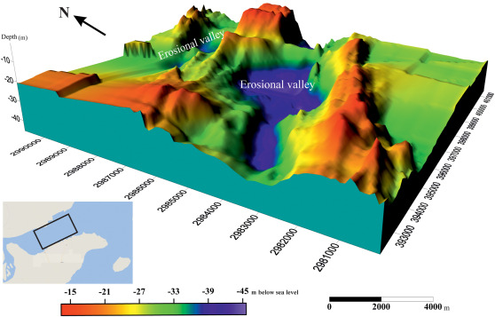
Isochore/time thickness maps (in milliseconds of TWT) over the seismic Unit 1 in the NQIW. Subsequent relative sea-level fall led to development of erosion surface and valley after deposition of seismic Unit 1. https://doi.org/10.1016/j.quaint.2020.11.051
Methods Used to Reconstruct Holocene Sea Levels
Sediment cores and stratigraphy
Much of what is known about Holocene sea-level change in the Persian Gulf comes from sediment cores. By analyzing grain size, fossil assemblages, and geochemical signatures, scientists reconstruct past environments and infer relative sea levels.
These methods provide vertical timelines that can be correlated across the basin, revealing coherent patterns of transgression, stabilization, and minor regression.
Geomorphological indicators
Ancient shorelines, beach ridges, and tidal-flat deposits preserved on land offer additional clues. When combined with subsurface data, these geomorphological markers help map the spatial extent of past coastlines.
For maritime engineers, such reconstructions explain why certain coastal stretches behave differently under wave and current forcing, reflecting inherited geomorphology rather than present-day conditions alone.
Challenges and Practical Solutions
A key challenge in applying Holocene sea-level knowledge to modern maritime planning is scale. Geological timescales can feel disconnected from operational timelines measured in years or decades. Yet ignoring this long-term context risks repeating mistakes, such as siting infrastructure in areas historically prone to rapid shoreline change.
A practical solution is to integrate geological baseline studies into early-stage port and offshore project planning. Understanding whether a site lies on stable mid-Holocene deposits or younger, more mobile sediments can inform foundation design, dredging expectations, and lifecycle costs.
Another challenge is uncertainty. Holocene reconstructions inevitably involve ranges rather than exact numbers. Instead of viewing this uncertainty as a weakness, maritime planners can treat it as a guide to risk envelopes, encouraging adaptive and flexible design strategies.
Case Studies and Real-World Applications
One clear application of Holocene sea-level research is in port expansion projects. Ports built on reclaimed land often overlie thick Holocene sediment sequences deposited during marine transgression. Knowledge of these sequences helps explain differential settlement and guides ground improvement techniques.
Another application lies in offshore routing. Submerged paleo-channels identified through seismic surveys can act as sediment traps or zones of variable seabed strength. Routing pipelines or cables with awareness of these features reduces long-term maintenance risks.
Finally, coastal management initiatives increasingly use Holocene shoreline data to contextualize modern erosion. Distinguishing between naturally mobile coasts and those destabilized by recent human intervention improves the credibility of mitigation measures.
Future Outlook and Maritime Trends
As concerns about modern sea-level rise intensify, Holocene analogues from the Persian Gulf provide valuable perspective. They show how sensitive shallow basins are to even small changes in sea level and how coastlines respond over centuries rather than years.
Future maritime planning in the region is likely to integrate geological history more explicitly, particularly in climate adaptation strategies. Digital seabed models, combined with paleo-reconstructions, are emerging as tools for scenario testing—helping ports and coastal authorities visualize how today’s infrastructure might interact with tomorrow’s seas.
FAQ Section
What is the Holocene?
The Holocene is the current geological epoch, beginning about 11,700 years ago after the last ice age.
Was the Persian Gulf always filled with water?
No. During the early Holocene and earlier, much of the Gulf basin was dry land crossed by rivers.
Why did small sea-level rises have such a big impact?
Because the Persian Gulf is very shallow, even minor vertical changes flooded large horizontal areas.
Did sea level ever stop rising completely?
Sea-level rise slowed significantly in the mid-Holocene, allowing shorelines to stabilize for several thousand years.
Why is this history relevant for modern ports?
Holocene sediments influence seabed stability, dredging needs, and long-term coastal behavior.
Are there submerged archaeological sites in the Persian Gulf?
Potentially yes. Former landscapes and settlements may now lie beneath shallow marine sediments.
Conclusion
Holocene sea-level changes transformed the Persian Gulf from a river-dominated lowland into the shallow marine basin that underpins one of the world’s most important maritime regions. This history explains modern sedimentation patterns, coastal sensitivity, and navigation challenges that continue to shape maritime operations today.
For maritime professionals, appreciating this deep-time perspective encourages smarter planning, more resilient infrastructure, and a clearer understanding of how past, present, and future sea levels are connected. As sea-level rise returns to the center of global concern, the Holocene story of the Persian Gulf offers both cautionary lessons and valuable guidance.
References
-
International Maritime Organization – Marine Environmental Protection and Navigation
-
UNCTAD – Review of Maritime Transport
-
Marine Policy; Marine Pollution Bulletin; Journal of Quaternary Science
-
World Bank – Coastal Zone Management Resources
-
Bowditch, The American Practical Navigator
-
Research institutions: WHOI, Scripps Institution of Oceanography, National Oceanography Centre